Seaway monitoring method based on electronic chart

A technology for electronic charts and routes, applied in the field of navigation and navigation, to achieve the effect of ensuring the safety of navigation

Active Publication Date: 2013-03-13
TIANJIN NAVIGATION INSTR RES INST
View PDF4 Cites 16 Cited by
  • Summary
  • Abstract
  • Description
  • Claims
  • Application Information

AI Technical Summary

Problems solved by technology

[0003] The purpose of the present invention is to overcome the deficiencies in the prior art and provide a route monitoring method based on electronic charts, which can automatically analyze the route a

Method used


Image

  • Seaway monitoring method based on electronic chart
  • Seaway monitoring method based on electronic chart
  • Seaway monitoring method based on electronic chart

Examples


Embodiment Construction

[0024] Embodiments of the present invention will be described in further detail below in conjunction with the accompanying drawings.

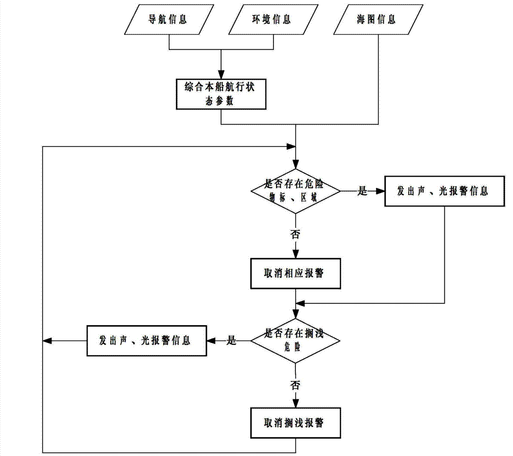
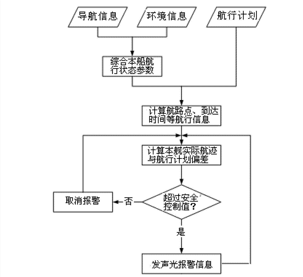
[0025] A route monitoring method based on electronic chart, such as figure 1 and figure 2 shown, including the following steps:

[0026] Step 1: Establish the planned route: edit the geographic coordinates of each waypoint, set the turning radius of each waypoint and the planned speed of each flight segment.

[0027] In this embodiment, the planned route Route1 is established: waypoint 1 (38°57.237'N, 117°53.631'E), waypoint 2 (38°57.145'N, 117°54.003'E), waypoint 3 (38° 57.049'N, 117°54.187'E), waypoint 4 (38°56.961'N, 117°54.294'E), waypoint 5 (38°56.806'N, 117°54.339'E), waypoint 6 (38 °56.694'N, 117°54.430'E), waypoint 7 (38°56.673'N, 117°54.608'E), the turning radius is 0.1nmile, and the planned speed is 15kn.

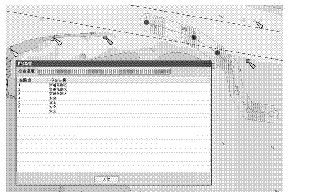
[0028] Step 2: Divide each route segment by waypoints, and build a route inspection buffer zone for each route segment accor...


PUM


Abstract

The invention relates to a seaway monitoring method based on an electronic chart, which comprises the following steps: 1, establishing a planned sea route; 2, establishing a sea route inspection buffer area; 3, inspecting whether an implicit factor which influences navigation safety exists in the sea route inspection buffer area or not, and marking; 4, travelling all seaway segments, and marking all dangerous seaway segments; 5, modifying the planned sea route according to a sea route inspection result, and storing the planned sea route to a sea route library; 6, carrying out dynamic sea route monitoring on the planned sea route as a main sea route, and establishing a dynamic navigation monitoring buffer area in the navigating process; 7, inspecting whether the implicit factor which influences the navigation safety exists in the dynamic navigation monitoring buffer area or not; 8, judging a current seaway segment, and predicting a next arrived seaway point, and sending alarm information when navigating to a certain predetermined distance from the next seaway point. The seaway monitoring method disclosed by the invention can be used for automatically analyzing the implicit dangerous factor in the navigating process along the planned sea route on the basis of the electronic chart by respectively adopting a static method and a dynamic method, thereby being conductive to ensuring the navigation safety of ships.

Description

technical field [0001] The invention belongs to the field of navigation and navigation, in particular to a route monitoring method based on an electronic chart. Background technique [0002] During the ship's voyage, there are some dangerous factors that affect the safety of navigation: stranding in dangerous areas, crossing safety contours, crossing restricted areas, crossing dangerous areas, crossing areas defined by navigators as forbidden navigation, approaching dangerous objects, ships Therefore, how to ensure the navigation safety of ships is an urgent problem to be solved at present. Although positioning, compass, sounding, radar and other equipment are generally installed on existing ships, these equipment work independently and do not make full use of electronic navigation charts (ENC) and other information related to navigation. Electronic chart information and display System (ElectronicChart Display and Information System), its navigation safety is mainly guarant...

Claims


Application Information

Patent Timeline
IPC IPC(8): G01C21/00
Inventor 张晶晶张瑞波赵燕周璐傅天爽
Owner TIANJIN NAVIGATION INSTR RES INST
Why Eureka
Try Eureka