Inland river intelligent navigation mark position monitoring method

A navigation mark and intelligent technology, applied in the direction of energy-saving control technology, lighting devices, lamp circuit layout, etc., can solve problems such as management errors, confusion, and large errors, and achieve the effect of avoiding false alarms and preventing omissions

Inactive Publication Date: 2017-01-18
DALIAN MARITIME UNIVERSITY
View PDF4 Cites 3 Cited by
  • Summary
  • Abstract
  • Description
  • Claims
  • Application Information

AI Technical Summary

Problems solved by technology

[0004] Due to the weak computing power of the microprocessor of the navigation mark intelligent terminal itself, this alarm mode does not use projection transformation when calculating the distance, but uses v

Method used


Image

  • Inland river intelligent navigation mark position monitoring method
  • Inland river intelligent navigation mark position monitoring method
  • Inland river intelligent navigation mark position monitoring method

Examples


Embodiment Construction

[0025] In order to make the purpose, technical solutions and advantages of the embodiments of the present invention clearer, the technical solutions in the embodiments of the present invention will be clearly and completely described below in conjunction with the drawings in the embodiments of the present invention. Obviously, the described embodiments It is a part of embodiments of the present invention, but not all embodiments. Based on the embodiments of the present invention, all other embodiments obtained by persons of ordinary skill in the art without creative efforts fall within the protection scope of the present invention.

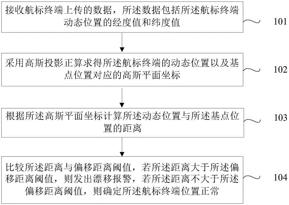
[0026] figure 1 It is a flow chart of the method for monitoring the position of the inland navigation mark of the present invention, as figure 1 As shown, the method of this embodiment includes:

[0027] Step 101, the data uploaded by the beacon terminal, the data includes the longitude value and latitude value of the dynamic position of the bea...


PUM


Abstract

The invention provides an inland river intelligent navigation mark position monitoring method. The method comprises steps that the data transmitted by a navigation mark terminal is received, and the data comprises longitude/latitude values of the dynamic position of the navigation mark terminal; gauss-kruger projection forward calculation is employed to solve the dynamic position of the navigation mark terminal and a gauss plane coordinate corresponding to the base point position; a distance between the dynamic position and the base point position is calculated according to the gauss plane coordinate; the distance is compared with an offset distance threshold, if the distance is greater than the offset distance threshold, drift alarm is carried out, if the distance is not greater than the offset distance threshold, the position of the navigation mark terminal is determined to be normal. Through the method, a problem of imprecise calculation of the navigation mark terminal is solved, accuracy and timeliness of drift alarm are improved, error alarm and missed alarm can be avoided, and guarantee is provided for ship navigation safety.

Description

technical field [0001] The embodiments of the present invention relate to the field of navigation mark monitoring, and in particular to a method for monitoring the position of an inland river intelligent navigation mark. Background technique [0002] The malfunction of the navigation mark refers to the loss of the navigation aid function of the navigation mark that should have been functioning, including buoy drift, sinking, light extinguishing, sign collapse and other serious damage. When the buoy management and maintenance personnel find that the buoy is abnormal, they should restore it in time, otherwise it will cause a great threat to the safety of the ship's navigation. Buoy drift is the most serious situation in the abnormal situation of buoys, which will bring great harm to the safety of ship navigation. In my country's inland rivers, ship collision and flood impact are the main reasons for buoy drift. After the navigation mark drifts, it is easy to cause the ship t...

Claims


Application Information

Patent Timeline
IPC IPC(8): H05B37/02
CPCH05B47/10Y02B20/40
Inventor 郝江凌郝雪凝潘明阳胡景峰
Owner DALIAN MARITIME UNIVERSITY
Why Eureka
Try Eureka