Supercharge Your Innovation With Domain-Expert AI Agents!

System and method for estimating indoor location using satellite signal generation device

A satellite signal and generating device technology, applied in satellite radio beacon positioning system, radio wave measurement system, measuring device, etc., can solve the problems of rising manufacturing and installation costs, difficulties, and failure to correctly adjust the radio frequency power of the transmitting antenna, etc. Achieve improved accuracy and cost savings

Active Publication Date: 2015-03-25
李雨燮 +2
View PDF2 Cites 0 Cited by
  • Summary
  • Abstract
  • Description
  • Claims
  • Application Information

AI Technical Summary

Problems solved by technology

[0006] First, even if the retransmission signal is received by the transmitting antenna (TX ANT), it is considered the coordinates of the receiving antenna (RX ANT), so there is a serious vertical error problem, and the interval between the installation of the receiving antenna becomes a horizontal error problem
In order to improve the horizontal error, multiple receiving antennas (RX ANT) are required, so it is difficult to increase the manufacturing and installation costs
[0007] Second, the location of the receiving antenna installed outdoors and the location of the corresponding indoor transmitting antenna (TX ANT) must be correctly matched. Due to the topography of the roof, it is actually very difficult to correctly install multiple receiving antennas on the roof
[0008] Third, if figure 1 The dotted lines shown have different loss rates according to the lead-in distance of each cable, so the electric field strength of each antenna terminal must be adjusted during installation
[0009] Fourth, depending on the installation position of the receiving antenna, there is a problem of receiving different coordinate values
This problem has a large impact on the vertical error rate
[0010] Fifth, the RF power (RF Power) between the transmitting antennas is not adjusted correctly, and the terminal continues to receive signals from the transmitting antenna with high RF power

Method used


Image

  • System and method for estimating indoor location using satellite signal generation device
  • System and method for estimating indoor location using satellite signal generation device
  • System and method for estimating indoor location using satellite signal generation device

Examples


Embodiment Construction

[0033] Hereinafter, preferred embodiments of the present invention will be described in detail with reference to the accompanying drawings.

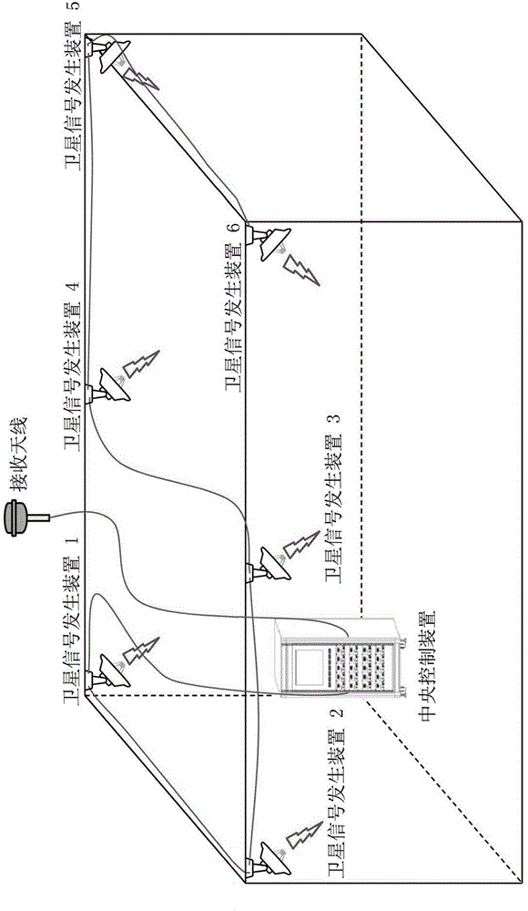
[0034] figure 2 is a configuration diagram of an indoor position measuring system according to the present invention.

[0035] according to figure 2 , the indoor position measurement system utilizing satellite signal generating device of the present invention, comprises: receiving antenna, it receives satellite signal; The received satellite signal extracts the satellite time and synchronizes it, based on the satellite time information, selects at least four satellite numbers that can measure the position among all the actual satellites; more than one satellite signal generation device, from the central control device Assigning a satellite number and generating a satellite signal corresponding to the satellite number assigned from said central control device;

[0036] The receiving antenna is an antenna installed outdoors for receiv...


PUM


Abstract

The present invention relates to a system and a method for estimating a location for freely providing location estimation service to a user owning a satellite signal receiving terminal, such as an existing mobile phone or a navigator, without having to change any hardware or software, even in shadow areas where satellite signals cannot reach easily, such as inside buildings, underground commercial quarters, tunnels, and subways. The system for estimating an indoor location of using a satellite signal generation device of the present invention comprises: a reception antenna for receiving satellite signals; a central control device for calculating and renewing real-time satellite information of all existing satellites, for extracting and synchronizing satellite time from the satellite signal which is received from the reception antenna, and selecting at least four satellite numbers that can be used for estimating the location from the all existing satellites, based on the satellite time information; and at least one satellite signal generation device for being allocated the satellite number from the central control device and generating the satellite signal which corresponds to the allocated satellite number, wherein an environment is provided for a user of an indoors satellite signal receiving terminal to estimate the location of oneself, based on the satellite signal that corresponds to the at least four satellite numbers, which are transmitted from the satellite signal generation device.

Description

technical field [0001] The present invention relates to an indoor position measurement system and its method using a satellite signal generating device, more specifically, to a shadow area where satellite signals are difficult to reach inside buildings, underground shopping malls, tunnels and subways, etc. A position measurement system and method thereof that can freely provide position measurement services to users who have satellite signal receiving terminals such as mobile phones or navigators without changing any hardware or software. Background technique [0002] Generally, the position measurement system measures the position of the receiving terminal by triangulation after receiving satellite signals from satellites 19,000 to 25,000 km above the ground. [0003] At the same time, the location measurement system has the limitation that it can only measure the location from the outdoors that directly receive satellite signals, and indoors such as buildings, underground ...

Claims


Application Information

Patent Timeline
Patent Type & Authority Patents(China)
IPC IPC(8): H04W4/02G01S19/24
CPCG01S19/24G01S19/11G01S19/256G01S19/20H04W64/00
Inventor 李雨燮申熙台郑宽默
Owner 李雨燮
Features
  • R&D
  • Intellectual Property
  • Life Sciences
  • Materials
  • Tech Scout
  • Unparalleled Data Quality
  • Higher Quality Content
  • 60% Fewer Hallucinations
Learn More