Copyright protection method and system for geospatial data products
A geospatial data and copyright protection technology, applied in the direction of program/content distribution protection, etc., can solve the problems of difficult accountability, high cost, and poor operability after the event, and achieve the effect of convenient tracking and mining
- Summary
- Abstract
- Description
- Claims
- Application Information
AI Technical Summary
Problems solved by technology
Method used
Image
Examples
Embodiment Construction
[0040] In order to make the above objects, features and advantages of the present invention more comprehensible, the present invention will be further described in detail below in conjunction with the accompanying drawings and specific embodiments.
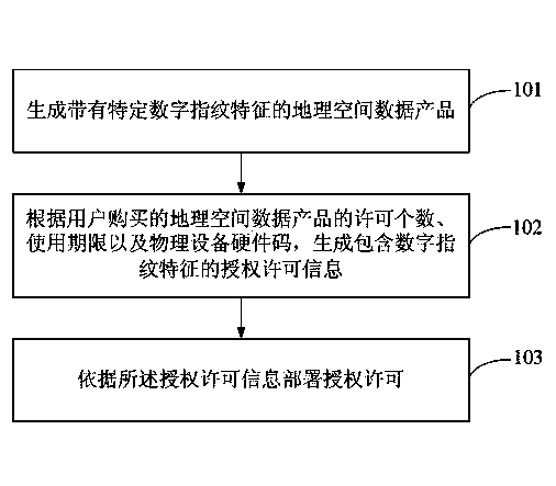
[0041] refer to figure 1 , which shows a schematic flow chart of the copyright protection method for geospatial data products of the present invention at the issuing stage, including the following steps:
[0042] Step 101. Generate geospatial data products with specific digital fingerprint features.
[0043] In this step 101, the transformed digital fingerprint information is implanted in the geospatial data content, and the digital fingerprint information includes information such as the copyright owner, release version, release time, and random code of the geospatial data product.
[0044] Step 102, according to the number of licenses of the geospatial data product purchased by the user, the period of use, and the hardware cod...
PUM
 Abstract
Description
Claims
Application Information
 - R&D
- Intellectual Property
- Life Sciences
- Materials
- Tech Scout
- Unparalleled Data Quality
- Higher Quality Content
- 60% Fewer Hallucinations
Browse by: Latest US Patents, China's latest patents, Technical Efficacy Thesaurus, Application Domain, Technology Topic, Popular Technical Reports.
© 2025 PatSnap. All rights reserved.Legal|Privacy policy|Modern Slavery Act Transparency Statement|Sitemap|About US| Contact US: help@patsnap.com


