On-line Interactive Mapping Method of Space Vector Data Based on Hierarchical Division Storage Structure

A space vector and data technology, applied in the field of interactive mapping of space vector data, can solve the problems of service quality degradation, loss of response, heavy server load, etc., to avoid hierarchical division processing calculations, reduce I/O time, and reduce computing costs. Effect

Active Publication Date: 2017-01-25
NAT UNIV OF DEFENSE TECH
View PDF3 Cites 0 Cited by
  • Summary
  • Abstract
  • Description
  • Claims
  • Application Information

AI Technical Summary

Problems solved by technology

Consumes a lot of server resources, resulting in slow system response and degraded service quality
Especially when users operate large-scale spatial vector data, intensive query operations will cause disk I / O to be in a high load state for a long time
Under high concurrency conditions, the server will be overloaded and even unresponsive

Method used


Image

  • On-line Interactive Mapping Method of Space Vector Data Based on Hierarchical Division Storage Structure
  • On-line Interactive Mapping Method of Space Vector Data Based on Hierarchical Division Storage Structure
  • On-line Interactive Mapping Method of Space Vector Data Based on Hierarchical Division Storage Structure

Examples


Embodiment Construction

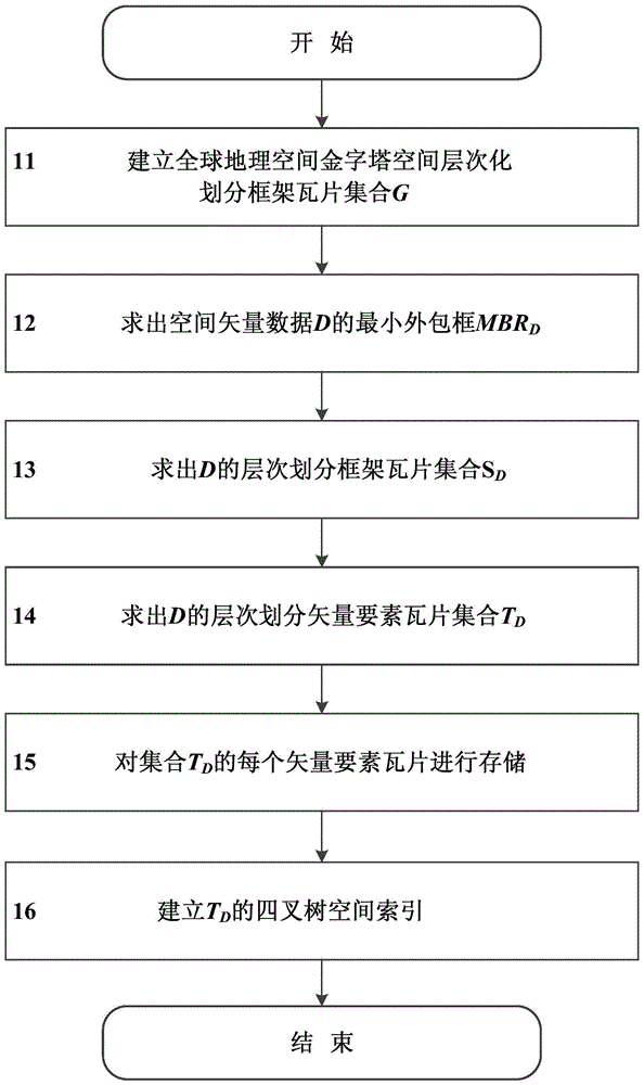
[0021] Assuming that the space vector data operated by the user for online interactive mapping is D, the method provided by the present invention will be described in detail below with reference to the accompanying drawings.

[0022] figure 1 It is a schematic flowchart of a large-scale space vector data hierarchical division storage structure generation method provided by the present invention, including six steps:

[0023] Step 11, based on the WGS 1984 Web Mercator global geographic space projection coordinate system, project the global geographic space onto a square surface, and establish a global geographic space pyramid hierarchically divided frame tile set G, G is a frame tile data structure covering the whole world (following A collection composed of tiles for short), described as:

[0024] G={g(l,r,c):0≤l≤N-1; 0≤r≤2 l -1; 0≤c≤2 l -1}

[0025] Among them, the element g(l,r,c) is a tile, which is positioned by three parameters, namely:

[0026] l: layer number. l ...


PUM


Abstract

The invention provides a spatial vector data online interactive mapping method based on a hierarchical-divided storage structure. According to the technical scheme, the method includes setting spatial vector data operated in user online interactive mapping as D, namely firstly establishing a hierarchical-divided storage structure TD of the spatial vector data D, and secondly, performing online interactive mapping of a hierarchical-divided vector element tile set TD based on D. The method includes: firstly, allowing a server to calculate and acquire a layer number L of mapping area in global geospatial pyramid hierarchical-divided framework tile set G; secondly, performing spatial topological intersection operation on geographical coordinate range R and TD in the Lth layer, and acquiring a vector element tile subset TD'; finally, allowing the server to perform mapping rendering on vector element data according to description of mapping style ST and form and return mapping results to the client. The online interactive mapping method is more rapid and efficient, and can be applied to most server geographic information system.

Description

technical field [0001] The invention relates to an interactive mapping method for space vector data in a geographic information system, in particular to an online interactive mapping method for large-scale spatial vector data in a server-based geographic information system. Background technique [0002] In the mobile Internet era, geographic information systems and geographic information applications have begun to be built using server architecture. The Web-based server architecture greatly enhances the sharing of geospatial data, reduces the burden on the client, and expands the scope of application. Compared with the traditional desktop architecture, the server architecture realizes the processing and management of large-scale spatial data sets, and promotes the development of large-scale geographic information applications. [0003] Interactive mapping, as one of the core functions of geographic information systems, must adapt to the impact of server architecture, mainly...

Claims


Application Information

Patent Timeline
Patent Type & Authority Patents(China)
IPC IPC(8): G06F17/30
CPCG06F16/29
Inventor 陈荦景宁刘露熊伟吴秋云孙璐
Owner NAT UNIV OF DEFENSE TECH
Why Eureka
Try Eureka