Coordinate point positioning method for matching two-dimensional map with three-dimensional map

A technology of two-dimensional maps and three-dimensional maps, which is applied in the directions of maps/plans/charts, educational tools, geographic information databases, etc., can solve problems such as the inability to re-match and locate two-dimensional coordinate points and three-dimensional coordinate points, so as to reduce workload and effect of complexity

Active Publication Date: 2014-05-21
HEFEI YITU NETWORK SCI & TECH CO LTD
View PDF6 Cites 32 Cited by
  • Summary
  • Abstract
  • Description
  • Claims
  • Application Information

AI Technical Summary

Problems solved by technology

[0005] The purpose of the present invention is to solve the defect that the two-dimensional coordinate point and the three-dimensional coordinate point cannot be re-matched and positioned after the three-dimensional map surface is rotated or tilted in the prior art, and to provide a coordinate point for matching the two-dimensional map and the three-dimensional map positioning method to solve the above problems

Method used


Image

  • Coordinate point positioning method for matching two-dimensional map with three-dimensional map

Examples


Embodiment Construction

[0030] In order to have a further understanding and understanding of the structural features of the present invention and the achieved effects, the preferred embodiments and accompanying drawings are used for a detailed description, as follows:

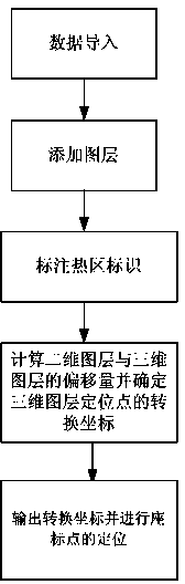
[0031] Such as figure 1 As shown, a coordinate point positioning method for matching a two-dimensional map and a three-dimensional map according to the present invention comprises the following steps:

[0032] The first step is data import, which is to import data from two-dimensional maps and three-dimensional maps. Through the data import of 2D map and 3D map, the display range and current layer information of 2D map and 3D map can be obtained, and the basic information of relevant data processing can be obtained, such as: coordinate point information and layer information of 2D map and 3D map , rotation angle, tilt angle, offset angle, tile call path, etc., for later use in data processing.

[0033] The second step is to add a l...


PUM


Abstract

The invention relates to a coordinate point positioning method for matching a two-dimensional map with a three-dimensional map. Compared with the prior art, the method overcomes the defect that a two-dimensional coordinate point and a three-dimensional coordinate point can not be matched or positioned again after the three-dimensional map rotates or inclines. The method includes the steps that data are imported; a map layer is added; hotspot marks are made; the offset of a two-dimensional map layer and the offset of a three-dimensional map layer are calculated, and the conversion coordinates of a positioning point of the three-dimensional map layer are determined; the conversion coordinates are output, and the coordinate points are positioned. By means of the method, the positioning points can be positioned again after the three-dimensional map rotates or inclines, and conversion between two-dimensional coordinates and three-dimensional coordinates can be achieved through calculation.

Description

[0001] technical field [0002] The invention relates to the technical field of coordinate point positioning, in particular to a coordinate point positioning method for matching a two-dimensional map with a three-dimensional map. [0003] Background technique [0004] Now 3D maps are being used more and more in daily life because of their intuitiveness. The images of 3D maps can be presented on the 3D surface, so that buildings, mountains, urban objects, urban management components and other things can be displayed in front of users more vividly. . However, if you want to achieve the best display effect on the 3D graphics, you generally need to rotate or tilt the 3D graphics on the original basis. After the 3D map is rotated or tilted, when it is necessary to match the 2D map with the 3D map, the 3D map cannot correspond to the coordinate position of the 2D map because of the rotation or tilt, and the existing 2D The three-dimensional and three-dimensional map matching me...

Claims


Application Information

Patent Timeline
Patent Type & Authority Applications(China)
IPC IPC(8): G06F17/30G09B29/10
CPCG06F16/29G09B29/10
Inventor 邵永培黄兴邱繁荣崔敏何鹏
Owner HEFEI YITU NETWORK SCI & TECH CO LTD
Why Eureka
Try Eureka