
Day and night separation vicarious calibration method for high-definition satellite wide-view filed imager

A technology for high-resolution satellites and imagers, which is applied to instruments, electromagnetic wave re-radiation, and utilization of re-radiation, etc. It can solve the problem of absolute radiation calibration method using conditions, calculation process and model accuracy, and the lack of real-time dark noise signals on the satellite. Monitoring functions and other issues to achieve the effect of taking into account system performance and algorithm feasibility, improving accuracy, and enhancing practicability

Active Publication Date: 2014-11-05
CHINA CENT FOR RESOURCES SATELLITE DATA & APPL
View PDF1 Cites 8 Cited by
  • Summary
  • Abstract
  • Description
  • Claims
  • Application Information

AI Technical Summary

Problems solved by technology

[0003] At present, there are many achievements in absolute radiometric calibration at home and abroad, but due to the various differences in the parameter settings, characteristics and on-board functions of satellite optical remote sensors, plus the conditions of use, calculation process and The accuracy of the model is also different, especially in the absence of real-time dark noise signal monitoring function on the satellite, it is difficult to directly apply an absolute radiometric calibration method to the on-orbit replacement calibration of the high-resolution satellite wide-field imager

Method used


Image

  • Day and night separation vicarious calibration method for high-definition satellite wide-view filed imager
  • Day and night separation vicarious calibration method for high-definition satellite wide-view filed imager
  • Day and night separation vicarious calibration method for high-definition satellite wide-view filed imager

Examples


Embodiment Construction

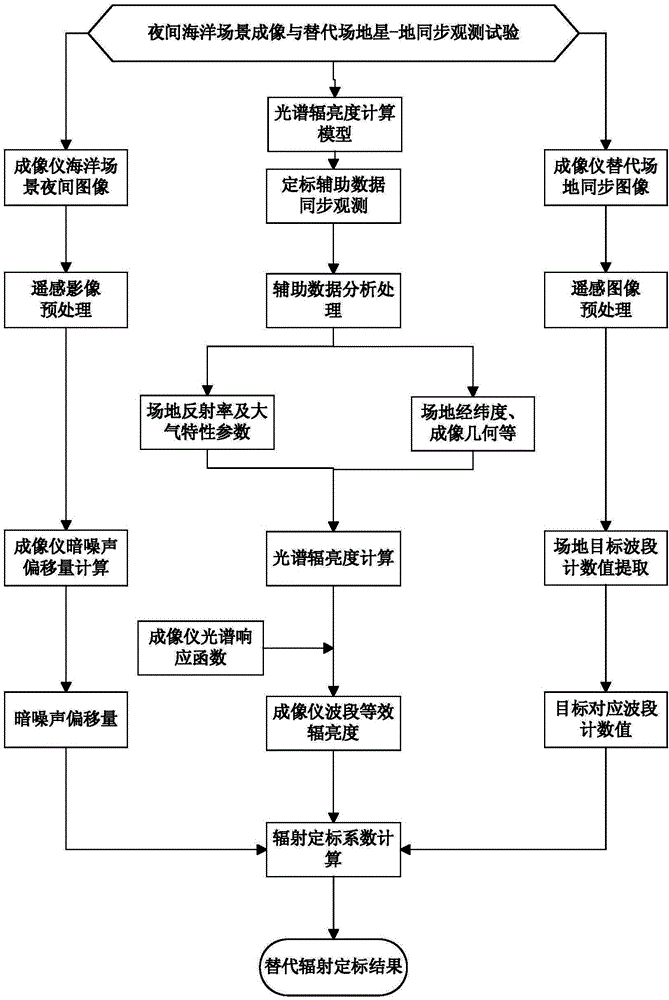
[0028] Below in conjunction with accompanying drawing, the present invention is described in detail, as figure 1 As shown, the specific steps are as follows:

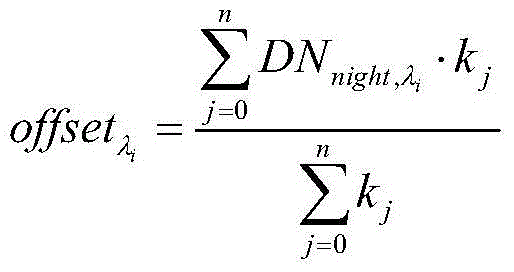
[0029] (1) Calculation of its own dark noise offset: read the original remote sensing image data of the high-resolution satellite wide-field imager’s nighttime ocean scene, preprocess the original data, obtain the corresponding first-level remote sensing image data, and The count value of each probe in the image is calculated according to the formula ① to calculate the dark noise offset of each band of the imager;

[0030] offset λ i = Σ j = 0 n DN night , λ 1 ...


PUM


Abstract

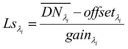
The invention discloses a day and night separation vicarious calibration method for a high-definition satellite wide-view filed imager. The method comprises steps: (1) remote sensing image data of the high-definition satellite wide-view filed imager in a night ocean scene are read, and offset of dark noise in each wave band is calculated according to the gray value generated by the dark noise of each detection unit; (2) a spectral radiation brightness calculation module at the entrance pupil of the satellite imager is determined; (3) the imager observes a specific field and imaging is carried out, auxiliary data needed by calculation of the model in the second step are synchronously observed on the ground, and the average counting value of each wave band of the specific field is extracted according to the remote sensing image data outputted when the imager observes the specific field; (4) the spectral radiation brightness at the entrance pupil of each wave band of the satellite imager is calculated, and in combination with features of the imager wave band spectral response function, wave band equivalent radiation brightness at the entrance pupil of the imager is calculated; and (5) according to the dark noise offset in the first step, the average counting value of each wave band of the specific field in the third step and the wave band equivalent radiation brightness at the entrance pupil of the imager of the fifth step, the on-orbit absolute radiometric calibration coefficient is calculated.

Description

technical field [0001] The invention relates to a day-night separation alternative calibration method for a high-resolution satellite wide-field imager, in particular to a day-night separation alternative calibration method for the Gaofen-1 satellite wide-field imager. Background technique [0002] The high-resolution satellite wide-field imager is an optical remote sensor that can quickly obtain the optical radiation information of large-area ground objects. Effective information resources, and the premise of the in-depth quantitative application of remote sensing information is to convert the output signal of the remote sensor into the actual physical quantity corresponding to the target, that is, to determine the quantitative relationship between the digital quantity and the physical quantity through absolute radiation calibration. [0003] At present, there are many achievements in absolute radiometric calibration at home and abroad, but due to the various differences in...

Claims


Application Information

Patent Timeline
Patent Type & Authority Applications(China)
IPC IPC(8): G01S7/497
CPCG01S7/497G01S17/89
Inventor 韩启金张学文傅俏燕潘志强王爱春刘李
Owner CHINA CENT FOR RESOURCES SATELLITE DATA & APPL
Learn More