Three-dimensional gis model display method and device

A display method and model technology, applied in the field of geographic information systems, can solve problems such as slow loading speed and low efficiency of 3D GIS models, and achieve the effect of improving efficiency

Inactive Publication Date: 2017-11-14
GUANGDONG VTRON TECH CO LTD
View PDF4 Cites 0 Cited by
  • Summary
  • Abstract
  • Description
  • Claims
  • Application Information

AI Technical Summary

Problems solved by technology

[0004] However, the existing technical vector data is stretched to generate a white model. If a refined model with high precision needs to be displayed, it is necessary to repeatedly load the refined model.
Usually the loading speed is relatively slow, resulting in very low efficiency of 3D GIS model display

Method used


Image

  • Three-dimensional gis model display method and device
  • Three-dimensional gis model display method and device

Examples


Embodiment Construction

[0018] In order to make the object, technical solution and advantages of the present invention clearer, the present invention will be further described in detail below in conjunction with the accompanying drawings and embodiments. It should be understood that the specific embodiments described here are only used to explain the present invention, not to limit the present invention.

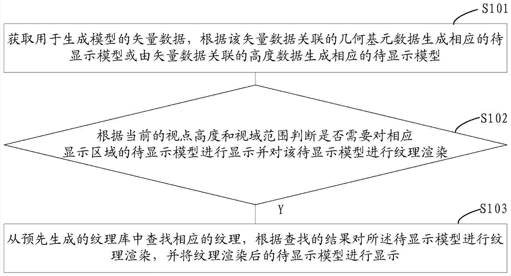
[0019] see figure 1 Shown, a kind of three-dimensional GIS model display method comprises the following steps:

[0020] Step S101, acquiring vector data for generating a model, generating a corresponding model to be displayed according to geometric primitive data associated with the vector data or generating a corresponding model to be displayed based on height data associated with the vector data. The model to be displayed can be a geometric model without texture by pulling up the vector data. It should be noted that the corresponding model to be displayed can be generated according to the geome...


PUM


Abstract

The present invention provides a method and device for displaying a three-dimensional GIS model. The method includes the following steps: obtaining vector data for generating a model; generate the corresponding model to be displayed; according to the current height of the viewpoint and the range of the field of view, determine whether it is necessary to display the model to be displayed in the corresponding display area and perform texture rendering on the model to be displayed; if so, from the pre-generated texture The corresponding texture is searched in the library, the texture rendering is performed on the to-be-displayed model according to the search result, and the texture-rendered to-be-displayed model is displayed. The three-dimensional GIS model display method and device of the present invention can improve the efficiency of refined display of massive three-dimensional GIS models.

Description

technical field [0001] The invention relates to the technical field of geographic information systems, in particular to a three-dimensional GIS model display method and a three-dimensional GIS model display device. Background technique [0002] On the video wall system, the good support of 3D GIS (Geographic Information System, geographic information system) massive model data is definitely a big blow to the market. In the prior art, the vector data in the 2D GIS development process is usually used when generating massive 3D GIS models, and users can quickly batch model by stretching the vector data, which saves a lot of labor. [0003] For example: quickly generate a rendering of high-rise buildings through the urban planning plan to provide a forward-looking preview for urban construction planning. Support terabyte-level vector data to generate white models, which is sufficient for city-level GIS applications. For example, through rapid modeling of all buildings in Beijin...

Claims


Application Information

Patent Timeline
Patent Type & Authority Patents(China)
IPC IPC(8): G06F17/30G06T17/05
CPCG06F16/2237G06F16/29G06T17/005G06T17/05
Inventor 林良辉
Owner GUANGDONG VTRON TECH CO LTD
Why Eureka
Try Eureka