Remote Sensing Image Scene Classification Method Based on Multi-channel Hierarchical Orthogonal Matching

A remote sensing image and scene classification technology, applied in the field of image processing, can solve problems such as large reconstruction errors, low LLC time complexity, and inflexible local descriptor representation, achieving high resolution and rich information

Active Publication Date: 2018-12-25
XIDIAN UNIV
View PDF2 Cites 0 Cited by
  • Summary
  • Abstract
  • Description
  • Claims
  • Application Information

AI Technical Summary

Problems solved by technology

Existing classical sparse coding methods such as LLC sparse coding, see references J.Wang, J.Yang, K.Yu, F.Lv, T.Huang, and Y.Gong.Locality-constrained linear coding for image classification.CVPR2010 ; LSC sparse coding method, see reference Lingqiao Liu, Lei Wang, Xinwang Liu, "In defense of soft-assignment coding", in ICCV, 2011, pp.2486-2493. These two methods are obtained by improving Hard coding , Hard coding is to reconstruct the descriptor with an atom closest to the local descriptor in the dictionary, such a tight constraint will lead to a large reconstruction error and the representation of the local descriptor is not flexible; LLC coding is to find The nearest K atoms to the descriptor reconstruct the descriptor to make up for the defects of Hard coding; LSC finds the K atoms closest to the descriptor, and then establishes the distance between the K atoms and the descriptor to be reconstructed Relationship, get sparse coding, lower time complexity than LLC

Method used


Image

  • Remote Sensing Image Scene Classification Method Based on Multi-channel Hierarchical Orthogonal Matching
  • Remote Sensing Image Scene Classification Method Based on Multi-channel Hierarchical Orthogonal Matching
  • Remote Sensing Image Scene Classification Method Based on Multi-channel Hierarchical Orthogonal Matching

Examples


Embodiment Construction

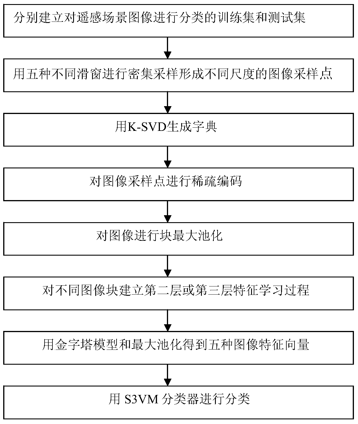
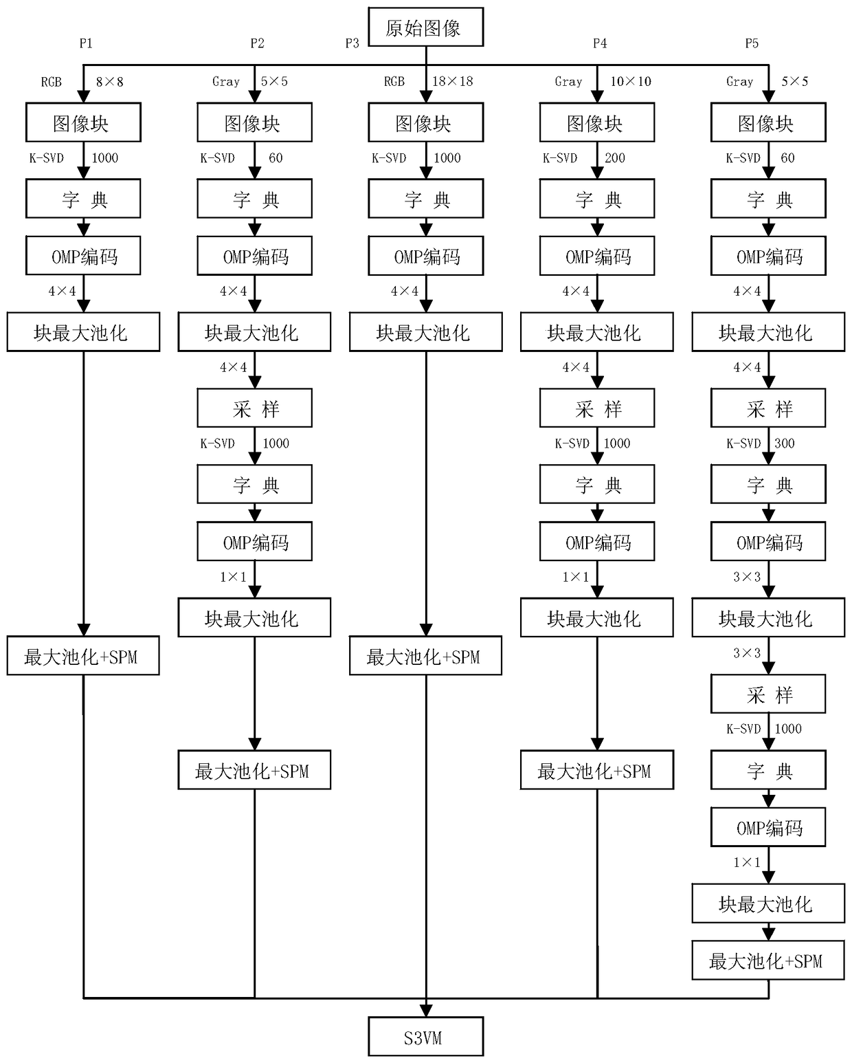
[0024] refer to figure 2 , the specific implementation steps of the present invention are as follows:

[0025] Step 1, respectively establish a training set and a test set for classifying remote sensing scene images;

[0026] (1a) Define remote sensing scene image datasets as N categories according to needs, and the category numbers are 1 to N;

[0027] (1b) Randomly select 80 images in each type of remote sensing scene images to form a training set for classifying remote sensing scene images, and the rest of the images are test sets for remote sensing scene image classification;

[0028] Step 2: Take a sliding window of size W1×W1 to densely sample each RGB image in the training set of remote sensing scene image classification and the test set of remote sensing scene image classification, establish a single-layer feature learning process P1, and obtain the image feature vector F1;

[0029] (2a) Take a sliding window of size W1×W1(8×8) to densely sample each RGB image in t...


PUM


Abstract

The invention discloses a remote sensing image scene classification method based on a multi-channel layered matching and tracking algorithm, which mainly solves the problem of low classification accuracy in the prior art. Training set and test set; (2) Use five different sliding windows to densely sample images to obtain image sampling points; (3) Use K-SVD algorithm dictionary learning; (4) Sparsely encode image sampling points; ( 5) Perform block max pooling on the image; (6) Establish the second or third layer feature learning process for the image block sizes obtained by different sliding windows; (7) Obtain the image feature vector by using the pyramid model and max pooling ; (8) Classify with a semi-supervised support vector machine. The invention fully utilizes the information of the image itself to establish a feature learning process of different levels and different paths, which can be used for scene detection and target recognition of remote sensing images.

Description

technical field [0001] The invention belongs to the technical field of image processing, relates to remote sensing image scene classification, and can be used for remote sensing image scene detection and image retrieval. Background technique [0002] With the rapid development of computer network technology and multimedia technology, remote sensing image scene classification has become a very important research field in image understanding, and has been widely used in image retrieval, computer vision and object recognition and other fields. Remote sensing image scene classification is a technology for automatic labeling of images based on image content. According to the type of features learned, it can be classified into two types: methods based on low-level features and methods based on middle-level features. Methods based on low-level features mainly include methods for classification based on color, texture, and shape; methods based on middle-level features achieve the pu...

Claims


Application Information

Patent Timeline
Patent Type & Authority Patents(China)
IPC IPC(8): G06K9/62
CPCG06F18/2411G06F18/214
Inventor 王爽焦李成鲍珍珍刘红英熊涛马文萍马晶晶梁建华
Owner XIDIAN UNIV
Why Eureka
Try Eureka