City large-area road network traffic sensing method based on plough satellite

An urban road network and large-area technology, applied in the field of urban large-area road network traffic perception based on Beidou, can solve the problems of inaccurate vehicle positioning and poor effect

Active Publication Date: 2015-04-29
HEFEI GELYU INFORMATION TECH
View PDF6 Cites 35 Cited by
  • Summary
  • Abstract
  • Description
  • Claims
  • Application Information

AI Technical Summary

Problems solved by technology

[0004] The urban road network environment is different from rural and suburban roads. Due to the influence of a large number of high-rise buildings, there is a deviation in the positioning of Beidou. At present, the normal deviation is about 10 meters. The effect is worse in places with many buildings. Positioning; at the same time, in the floating car information collection system, due to the huge scale of floating car map matching objects, especially for applications in large cities, it is necessary to complete the matching of tens of thousands of floating cars and tens of thousands of road sections in a relatively short period of time and path planning, the algorithm optimization degree of each processing flow is particularly important

Method used


Image

  • City large-area road network traffic sensing method based on plough satellite
  • City large-area road network traffic sensing method based on plough satellite
  • City large-area road network traffic sensing method based on plough satellite

Examples


Embodiment Construction

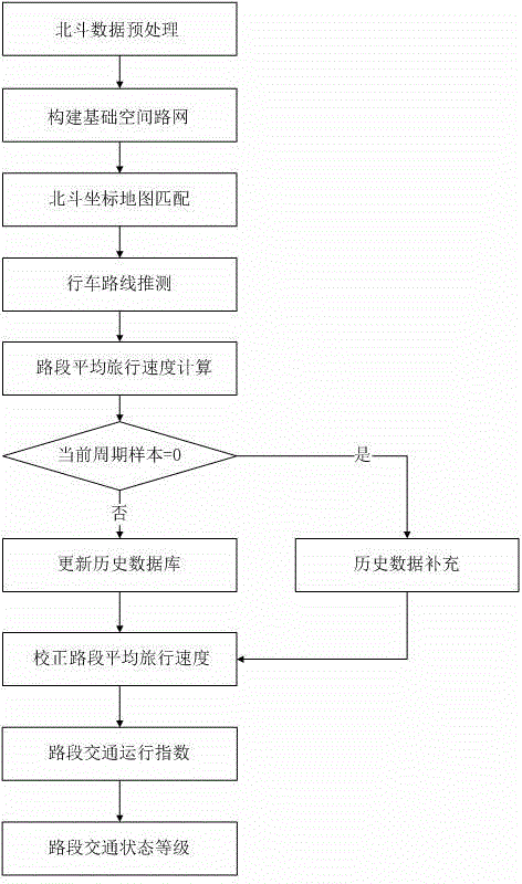
[0071] Below, the present invention will be further described in conjunction with the accompanying drawings and specific embodiments.

[0072] Such as figure 1 As shown, a Beidou-based urban large-area road network traffic perception method includes the following steps:

[0073] S1. Build a Beidou data preprocessing model to obtain the dynamic parameters of all Beidou floating vehicles in the urban road network, including time, coordinates and direction angle data, and effectively filter abnormal data (such as vehicle parking) to exclude abnormal data.

[0074] S11, Beidou floating vehicle travel speed preprocessing

[0075] The reasonable range of defining the travel speed v of the Beidou floating vehicle is: 1≤v≤f*v max , where f is the correction coefficient, v max is the maximum vehicle speed allowed by the road (km / h);

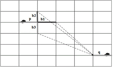
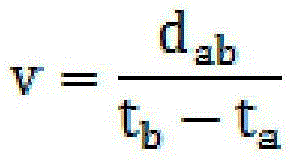
[0076] v = d ab t b ...


PUM


Abstract

The invention provides a city large-area road network traffic sensing method based on the plough satellite. The city large-area road network traffic sensing method comprises the steps of preprocessing plough satellite data; structuring a basic space road network; matching a plough satellite coordinate map; speculating driving routes; calculating the road segment average travel speed; supplementing historical data; correcting the road segment average travel speed; calculating road segment traffic operation indexes; judging road segment traffic state levels. According to the city large-area road network traffic sensing method, the traffic states within a large-area range of the road network are sensed by structuring a plough satellite data preprocessing model, a vehicle coordinate matching index model, a vehicle route planning module and a road segment traffic operation index model, the deviation of city road network plough satellite positioning is lowered under the high-rise building traffic environment, the collection and distribution accurate of city road traffic states are improved, and the traffic operation efficiency and the service level of the city road network are increased.

Description

technical field [0001] The invention relates to the technical field of urban road network traffic state perception based on Beidou data, in particular to a Beidou-based urban large-area road network traffic perception method. Background technique [0002] China's Beidou satellite navigation system is a global satellite navigation system developed by China itself. It is the third mature satellite navigation system after the American GPS and Russia's GLONASS. Now the application of Beidou navigation system-related civilian products is still in its infancy, and the future development potential is huge . [0003] Floating car traffic information collection technology is a technology that uses the dynamic position change information of the vehicle to extract real-time road conditions by installing Beidou BDS, American GPS and other devices on the vehicle. Based on the floating car displacement data, the vehicle position coordinates of the time series are compared with the map Ma...

Claims


Application Information

Patent Timeline
Patent Type & Authority Applications(China)
IPC IPC(8): G08G1/01G08G1/052
CPCG08G1/0112G08G1/052
Inventor 高万宝吴先会张广林邹娇
Owner HEFEI GELYU INFORMATION TECH
Why Eureka
Try Eureka