A Beidou-based vehicle route planning method and device for urban road network

A technology of urban road network and vehicle routing, applied in the field of urban road network vehicle routing, can solve the problems of inaccurate vehicle positioning, Beidou deviation, poor effect, etc., to improve accuracy, fast positioning, improve operating efficiency and service level Effect

Active Publication Date: 2017-06-23
宁波崛马信息科技有限公司
View PDF6 Cites 0 Cited by
  • Summary
  • Abstract
  • Description
  • Claims
  • Application Information

AI Technical Summary

Problems solved by technology

[0004] The urban road network environment is different from rural and suburban roads. Due to the influence of a large number of high-rise buildings, there is a deviation in the positioning of Beidou. At present, the normal deviation is about 10 meters. position

Method used


Image

  • A Beidou-based vehicle route planning method and device for urban road network
  • A Beidou-based vehicle route planning method and device for urban road network
  • A Beidou-based vehicle route planning method and device for urban road network

Examples


Embodiment Construction

[0039] Below, the present invention will be further described in conjunction with the accompanying drawings and specific embodiments.

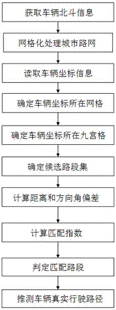
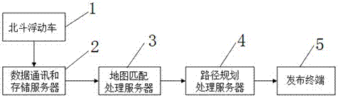
[0040] like figure 1 As shown, a Beidou-based urban road network vehicle route planning method is realized by using several Beidou floating vehicles 1, data communication and storage server 2, map matching processing server 3, route planning server 4 and publishing terminal 5 connected in sequence (such as image 3 shown), the method includes the following steps:

[0041] S1. Use the floating car technology to detect the dynamic parameters of all Beidou floating cars 1 in the urban road network, including time, coordinates and direction angle data. The detected dynamic parameters are stored in the map matching processing server 3 in real time through the data communication and storage server 2 .

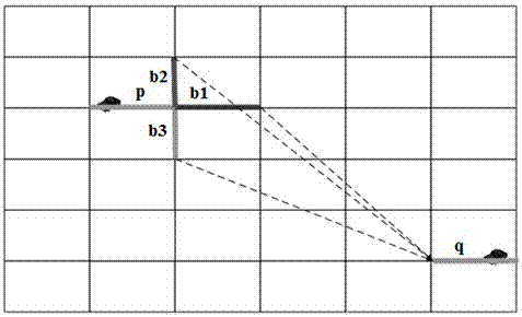
[0042] S2. Construct the basic model of the urban road network, and load the urban road network node set, road section set and routing set;

[004...


PUM


Abstract

The invention provides a Beidou-based urban road network vehicle path planning method which comprises the following steps: acquiring Beidou information of a vehicle; performing gridding processing on an urban road network; reading the vehicle coordinate information; determining the grid at which the vehicle coordinate is positioned; determining the Sudoku at which the vehicle coordinate is positioned; determining the candidate road section set; calculating the deviation of distance and direction angle; calculating the matching index; judging the matched road section; and estimating the real running path of the vehicle. The invention also provides a Beidou-based urban road network vehicle path planning device. According to the method and the device disclosed by the invention, a coordinate matching index model and a path planning model are established, rapid positioning of the vehicle coordinates and estimation of the running path in the urban road network are realized, the Beidou positioning deviation of the urban road network is reduced in a traffic environment of high-rise buildings, the vehicle monitoring and tracing accuracy is improved, and the operating efficiency and service level of a traffic information acquisition system are improved.

Description

technical field [0001] The invention relates to the technical field of urban road network vehicle route planning based on Beidou data, in particular to a Beidou-based urban road network vehicle route planning method and device. Background technique [0002] China's Beidou satellite navigation system is a global satellite navigation system developed by China itself. It is the third mature satellite navigation system after the American GPS and Russia's GLONASS. Now the application of Beidou navigation system-related civilian products is still in its infancy, and the future development potential is huge . [0003] Floating car traffic information collection technology is a technology that uses the dynamic position change information of the vehicle to extract real-time road conditions by installing Beidou BDS, American GPS and other devices on the vehicle. Based on the floating car displacement data, the vehicle position coordinates of the time series are compared with the map ...

Claims


Application Information

Patent Timeline
Patent Type & Authority Patents(China)
IPC IPC(8): G01C21/34
CPCG01C21/3446
Inventor 高万宝董婉丽余飞刘思宏吴先会邹娇李慧玲张广林朱蕾
Owner 宁波崛马信息科技有限公司
Why Eureka
Try Eureka