Earthquake disaster rescue command and dispatch system and method

A command and dispatch system and disaster technology, applied in the field of earthquake disaster rescue command and dispatch system, can solve the problems of difficult definition, difficulty, and difficult operation of the value, and achieve the effects of shortening the determination time, fast processing speed, and fast calculation speed

Active Publication Date: 2015-05-13
BEIJING INST OF AEROSPACE CONTROL DEVICES +1
View PDF10 Cites 39 Cited by
  • Summary
  • Abstract
  • Description
  • Claims
  • Application Information

AI Technical Summary

Problems solved by technology

At present, the medical groups in our country have the following problems when carrying out earthquake disaster relief: First, due to the impact of the earthquake damage, there are great difficulties in collecting and analyzing the disaster information in the disaster area, which makes it difficult to realize specific disaster relief decisions. the blindness of
The Chinese patent "Earthquake Emergency Joint Command and Dispatch Integrated System" (publication number CN202736112U) uses geographic information system and audio and video equipment to realize the centralized command and dispatch of earthquake disaster rescue, but the system does not comprehensively use remote sensing and aerial photography data to carry out disaster-stricken areas. The collection and analysis of disaster information cannot effectively evaluate and analyze the actual disaster situation in the disaster-stricken area
Secondly, the disaster rescue plan is not targeted enough, the guidance on disaster rescue is relatively vague, and there are more qualitative descriptions than quantitative analysis, so there are certain difficulties in the actual implementation of the plan
In the Chinese patent "Earthquake Damage Assessment System" (publication number CN102750456A), a two-dimensional grid model is mainly established for the distribution of personnel in the earthquake area, but the definition of each index of the system is relatively abstract, and the definition of the value is relatively difficult, so in practical application Difficult to operate
According to the disaster-stricken resources corresponding to the disaster-stricken unit and the disaster-relief resources corresponding to the disaster-relief unit in the Chinese patent "Disaster Relief Resources Allocation Method and Device" (publication number CN103150627A), the disaster-relief resources stored in the information of the unit are calculated according to the resource matching degree. distribution, the application of this method also has the problem of abstraction of model parameters

Method used


Image

  • Earthquake disaster rescue command and dispatch system and method
  • Earthquake disaster rescue command and dispatch system and method
  • Earthquake disaster rescue command and dispatch system and method

Examples


Embodiment Construction

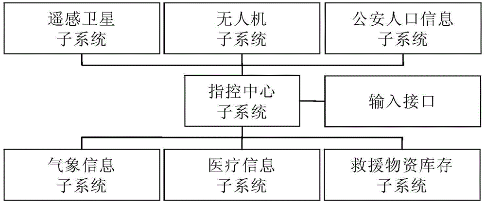
[0028] Such as figure 1 As shown, the earthquake disaster rescue command and dispatch system of the present invention consists of a control center subsystem, a remote sensing satellite subsystem, an unmanned aerial vehicle subsystem, a public security population information subsystem, a meteorological information subsystem, a medical information subsystem, and a rescue material inventory subsystem, and the input interface.

[0029]The remote sensing satellite subsystem is used to obtain the remote sensing image of the earthquake-stricken area and send the remote sensing image to the command center subsystem. The remote sensing satellite subsystem is composed of earth remote sensing satellites and ground remote sensing image data receiving and processing terminals. The images of the remote sensing satellites may be images collected by visible light, infrared, or microwave remote sensing imaging satellites, or images synthesized from multiple satellite images. Before the earth...


PUM


Abstract

Provided is an earthquake disaster rescue command and dispatch system and a method thereof; the system consists of a command center subsystem, a remote sensing satellite subsystem, an unmanned plane subsystem, a police population information subsystem, a weather information subsystem, a medical information subsystem, a relief goods repertory subsystem and input/output interfaces; by analyzing disaster information and disaster rescue information collected by each aforementioned system, a hierarchical model of earthquake disaster rescue can be built by an analytic hierarchy process; meanwhile, based on the actual situations of former earthquake disaster rescue, respective disaster rescue plan and analytic hierarchy process disaster rescue parameter database can be built. When an actual earthquake disaster happens, the current disaster situations are analyzed by the analytic hierarchy process, and the disaster rescue plan is quickly determined. The designed system and method herein are more applicable to collecting relative information quickly as soon as the earthquake happens, and automatically selecting the rescue plan for the command dispatch of the disaster rescue.

Description

technical field [0001] The invention relates to an earthquake disaster rescue command and dispatch system and method. Background technique [0002] my country is an earthquake-prone country. Because the land in the southwest region is at the junction of the Eurasian plate and the Indian Ocean plate, the region has suffered from earthquakes and secondary disasters in recent years, which have caused great harm to the country and people's production and life. When an earthquake occurs, relevant departments need to respond quickly according to the disaster situation, collect information on the affected area, integrate available resources, and make scientific and effective disaster rescue decisions and plans in the shortest possible time. At present, the medical groups in our country have the following problems when carrying out earthquake disaster relief: First, due to the impact of the earthquake damage, there are great difficulties in collecting and analyzing the disaster info...

Claims


Application Information

Patent Timeline
Patent Type & Authority Applications(China)
IPC IPC(8): G06Q10/06G06Q50/26
CPCG06Q10/063G06Q50/265
Inventor 刘皓挺王巍陈金宏吕明高云王学锋于文鹏王军龙马建立何哲玺宋伟
Owner BEIJING INST OF AEROSPACE CONTROL DEVICES
Why Eureka
Try Eureka