Land use pattern based land resource visualized calculation method and apparatus

A technology of land resources and calculation methods, applied in the field of land resource survey, to achieve the effect of improving the ability of complex problems

Active Publication Date: 2015-10-21
中国土地勘测规划院
View PDF0 Cites 4 Cited by
  • Summary
  • Abstract
  • Description
  • Claims
  • Application Information

AI Technical Summary

Problems solved by technology

[0007] Embodiments of the present invention provide a land resource visualization calculation method and device based on land use maps, the land resource visualization calculation results are more accurate, and can provide dynamic and more accurate solutions and decision support for land monitoring and evaluation, and improve Ability to solve complex problems in land ecosystems

Method used


Image

  • Land use pattern based land resource visualized calculation method and apparatus
  • Land use pattern based land resource visualized calculation method and apparatus
  • Land use pattern based land resource visualized calculation method and apparatus

Examples


Embodiment Construction

[0015] The following will clearly and completely describe the technical solutions in the embodiments of the present invention with reference to the accompanying drawings in the embodiments of the present invention. Obviously, the described embodiments are only some, not all, embodiments of the present invention. Based on the embodiments of the present invention, all other embodiments obtained by persons of ordinary skill in the art without making creative efforts belong to the protection scope of the present invention.

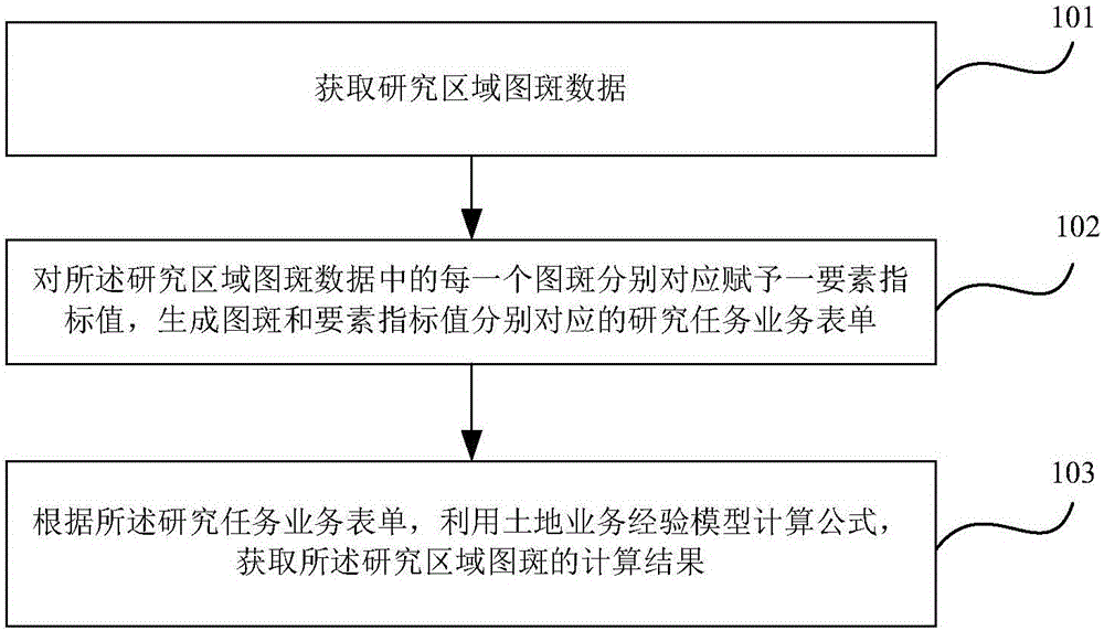
[0016] like figure 1 As shown, it is a flowchart of a land resource visualization calculation method based on land use maps according to an embodiment of the present invention. The land resource visualization calculation method based on land use maps includes:

[0017] 101. Obtain the map spot data of the research area;

[0018] 102. Assign an element index value to each map spot in the map spot data of the research area, and generate a research task business...


PUM


Abstract

An embodiment of the invention provides a land use pattern based land resource visualized calculation method and apparatus. The land use pattern based land resource visualized calculation method comprises the steps of: obtaining research region pattern data; correspondingly endowing each pattern in the research region pattern data with a factor index value to generate research task business forms corresponding to the pattern and the factor index value respectively; and according to the research task business forms, using a land business empirical model calculation formula to obtain a calculation result of the research region pattern. According to the technical scheme, the land resource visualized calculation method and apparatus have the following beneficial effects: dynamic and more accurate solution and decision support can be provided for land monitoring and evaluation, and the capabilities of land business workers in solving complex problems of a land ecologic system are improved through interaction between monitoring factor index data and an empirical model of related land resources as far as possible.

Description

technical field [0001] The invention relates to the technical field of land resource surveying, in particular to a land resource visualization calculation method and device based on land use maps. Background technique [0002] Land is a complex system composed of multiple factors. Therefore, in the study of land resources, all factors of land use should be considered comprehensively, which requires comprehensive research related to qualitative analysis and quantitative calculation. Calculation method of land resources monitoring indicators. [0003] From the perspective of supporting the research and analysis of complex geographical issues, geocomputation should include four "enabling technologies (ETs)": computer system and design (ET1); search, classification, prediction and modeling (ET2); knowledge Discovery (ET3); Visualization (ET4). Among them, ET2 covers the core technologies of intelligent computing and analysis in contemporary computer science; while ET3 emphasiz...

Claims


Application Information

Patent Timeline
Patent Type & Authority Applications(China)
IPC IPC(8): G06F19/00
Inventor 郭旭东鲁学军李柳柯武鹏达周和颐
Owner 中国土地勘测规划院
Why Eureka
Try Eureka