Remote sensing image building detection and classification method based on global optimization decision

A remote sensing image, global optimization technology, applied in the direction of instruments, character and pattern recognition, computer components, etc., to achieve the effect of broad application value and market prospects

Active Publication Date: 2015-12-23
BEIHANG UNIV
View PDF9 Cites 10 Cited by
  • Summary
  • Abstract
  • Description
  • Claims
  • Application Information

AI Technical Summary

Problems solved by technology

He uses color, discrete cosine transform coefficients and line features to classify, but t

Method used


Image

  • Remote sensing image building detection and classification method based on global optimization decision
  • Remote sensing image building detection and classification method based on global optimization decision
  • Remote sensing image building detection and classification method based on global optimization decision

Examples


Embodiment Construction

[0020] In order to better understand the technical solution of the present invention, the present invention will be described in detail below in conjunction with the accompanying drawings and specific embodiments.

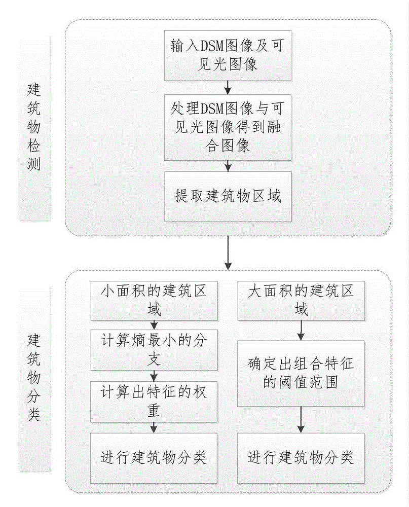
[0021] The invention is a method for detecting and classifying buildings in remote sensing images based on global optimization decision-making. The method mainly includes the following steps:

[0022] 1. Input remote sensing images acquired by digital imaging equipment such as airborne radar lasers and high-altitude cameras into the computer.

[0023] 2. Process the DSM image and the visible light image to obtain a fusion image, and extract the building area.

[0024] 3. Distinguish building areas by area, and classify large areas using combined features.

[0025] 4. Use the small-area buildings obtained in step 3 to calculate the branch with the smallest entropy and the weight of each feature to classify the buildings.

[0026] The concrete realization process o...


PUM


Abstract

A remote sensing image building detection and classification method comprises the following steps: acquiring DSM drawing data and visible light drawing data derived from an airborne radar laser; converting the size of the DSM drawing and performing the binarization of the DSM drawing; filtering the interference of the image edge, and merging the DSM drawing and the visible light drawing together; separating big and small white areas of the merged image, classifying the big areas through employing combination features, and deciding the features of the building classification of the small areas through employing the global optimization; classifying buildings according to preset threshold values of each feature, and calculating a branch having a minimum entropy; calculating a building area having a maximum purity in the branch; obtaining each feature weight through combining with the data, the maximal characteristic of the weight being this grade classification feature; and determining the sequence of the characteristics in order to realize the remote sensing image building detection and classification process. The remote sensing image building detection and classification method based on a global optimization decision may be used for the remote sensing image building detection and classification, has an important significance in the accurate detection and classification of the remote sensing image buildings, and has a broad market prospect and application value.

Description

technical field [0001] A remote sensing image building detection and classification method based on global optimization decision-making belongs to the field of digital image processing, and in particular relates to digital image processing technology for building detection and classification. Background technique [0002] With the development of the Internet, the problem people face is not the lack of image sources, but how to find the information you need among many images. This requires a precise technique to process the image. In the process of processing remote sensing images, the detection and classification of buildings is very important. The detection and classification of buildings in remote sensing images is playing an increasingly widespread role in land planning, disaster relief, etc. [0003] The detection and classification of buildings in remote sensing images includes not only the detection of buildings in one or more scenes, but also the detailed descriptio...

Claims


Application Information

Patent Timeline
IPC IPC(8): G06K9/62G06K9/00
CPCG06V20/176G06F18/24G06F18/25
Inventor 罗晓燕白椿山马媛媛
Owner BEIHANG UNIV
Why Eureka
Try Eureka