Eureka AIR delivers breakthrough ideas for toughest innovation challenges, trusted by R&D personnel around the world.

City near-surface layer thermal environment multi-point instant sampling measurement method

A thermal environment, near-ground technology, applied to measuring devices, diathermy meters, instruments, etc., can solve the problems of not considering the complexity of the city, not being able to measure at the same time, not considering other factors affecting the selection of measuring points, etc., to achieve accurate measured data The effect of large error, efficient and convenient measurement process, and accurate measurement point data

Active Publication Date: 2016-05-25
SOUTHEAST UNIV
View PDF3 Cites 9 Cited by
  • Summary
  • Abstract
  • Description
  • Claims
  • Application Information

AI Technical Summary

Problems solved by technology

[0004] ① From the perspective of the selection of the research object area, the existing technology mainly relies on the subjective judgment of the operator, regardless of the complexity of the city, and generally selects the urban core area as the research object, so that the selected measurement points cannot fully reflect the entire measurement area The actual situation of the near-surface thermal environment
[0005] ②From the point of view of the arrangement of measuring points in the target area, the existing technology arranges measuring points within a range of 500 meters. This reason lacks objective evaluation standards and does not consider other influencing factors for the selection of measuring points. The selection of measuring points lacks representativeness. sex
[0006] ③From the point of view of the process of simultaneous measurement of measuring points, the existing technology uses human monitoring, which cannot achieve real-time automatic measurement of multiple points. In many cases, due to emergencies and uncontrollable factors of the person itself, it is impossible to measure simultaneously during the measurement process

Method used


Image

  • City near-surface layer thermal environment multi-point instant sampling measurement method
  • City near-surface layer thermal environment multi-point instant sampling measurement method
  • City near-surface layer thermal environment multi-point instant sampling measurement method

Examples


Embodiment

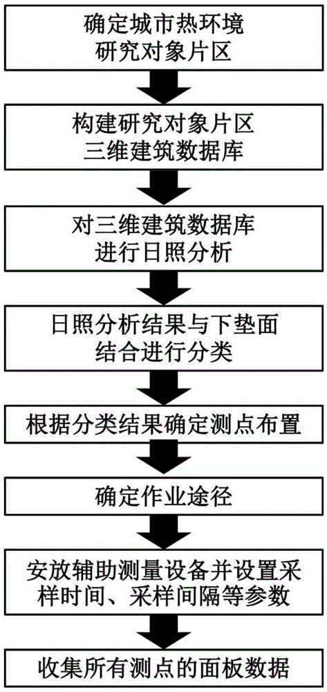
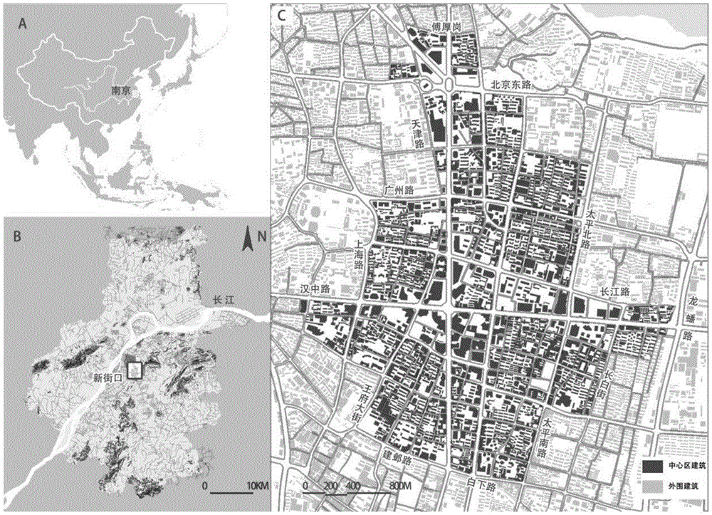
[0036] Embodiment: the technical scheme of the present invention will be described in detail below in conjunction with the multi-point real-time sampling measurement process and accompanying drawings of the thermal environment near the surface of Nanjing city, as Figure 2 to Figure 4 shown.

[0037] 1) Determine the research object area

[0038] First open the Nanjing urban meteorological data (relying on the existing data of the Urban Meteorological Bureau and the Urban Meteorological Research Institute) with the ECOTECTWEATHERTOOL software, and use the MONTHLYDATA (monthly data analysis) and WINDANALYSIS (wind analysis) of the ECOTECTWEATHERTOOL software to analyze, and obtain the Nanjing urban summer season. Climatic characteristics of thermal environment and summer monsoon environment. The analysis shows that the thermal environment in summer is characterized by high temperature and high humidity, and the summer monsoon environment is dominated by southeast wind with low...


PUM


Abstract

The invention provides a city near-surface layer thermal environment multi-point instant sampling measurement method. The method comprises steps that (1), the analysis demand is taken as a limiting condition, a measurement area is selected according to the meteorological data; (2), a three-dimensional building model of the measurement area is constructed on the basis of a city satellite map and the main street tree data, sunshine analysis on the three-dimensional building model is carried out, and a sunshine analysis model reflecting the relationship between latitude and longitude coordinates and the average sunshine duration of the measurement area is generated; subarea processing on the sunshine analysis model is carried out according to a type of an underlying surface of the measurement area, each subarea of a sunshine analysis graph is sampled by taking the average sunshine duration as an axis and deltat as the sampling time interval, and multiple sampling areas are acquired; N measurement points are uniformly distributed in each sampling area at equal density, and latitude and longitude coordinates of each measurement point are acquired; and (3), the equal-altitude thermal environment characteristic data of the measurement points is acquired. Through the method, objectivity of selected points and synchronism and completeness of data samples are realized.

Description

technical field [0001] The invention relates to the field of urban planning methods, in particular to a multi-point real-time sampling measurement method for the urban near-surface thermal environment. Background technique [0002] At present, the measurement methods of the thermal environment in urban areas have not formed a system, and the acquisition of urban heat island effect research data largely depends on the intellectual activities of the human brain. The logic of the existing thermal environment measurement point selection is relatively simple. The selection of the urban object area basically selects the core area of ​​the city; and then selects the point measurement for the urban core area. This process is highly random, usually with a distance of 500 meters Arrange the measuring points within a certain range; when measuring the measuring points, it is not possible to control multiple points to measure at the same time. Generally, it is manual monitoring, and the ...

Claims


Application Information

Patent Timeline
IPC IPC(8): G01W1/17G06F17/50
CPCG01W1/17G06F30/00Y02A90/10
Inventor 杨俊宴代鑫石邢
Owner SOUTHEAST UNIV
Why Eureka
Eureka Blog
Learn More