Aerial stereoscopic video streetscape system based on a navigation airship and an implement method

A technology of stereoscopic video and realization method, which is applied in the field of aircraft, can solve the problems of long period, large investment and high cost of ground acquisition methods, and achieve the effect of large field of view and height

Active Publication Date: 2016-06-22
SHENZHEN INST OF ADVANCED TECH
View PDF8 Cites 19 Cited by
  • Summary
  • Abstract
  • Description
  • Claims
  • Application Information

AI Technical Summary

Problems solved by technology

[0003] The current video street view system mostly uses street view vehicles to capture static two-dimensional data on the ground, lacking aerial observation capabilities and three-dimensional and dynamic visual effects; and limited by the accessibility of ground roads and vehicle traffic, it is impossible to achieve full coverage of the city; in addition, street view maps A large amount of data update and maintenance is required, and the ground acquisition method requires large investment, long cycle and high cost

Method used


Image

  • Aerial stereoscopic video streetscape system based on a navigation airship and an implement method
  • Aerial stereoscopic video streetscape system based on a navigation airship and an implement method
  • Aerial stereoscopic video streetscape system based on a navigation airship and an implement method

Examples


Embodiment Construction

[0036] In order to make the purpose, technical solution and advantages of the present invention clearer, the present invention will be further described in detail below in conjunction with the accompanying drawings and embodiments. It should be understood that the specific embodiments described here are only used to explain the present invention, not to limit the present invention.

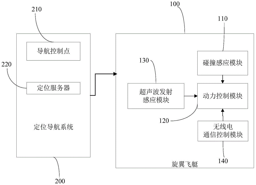
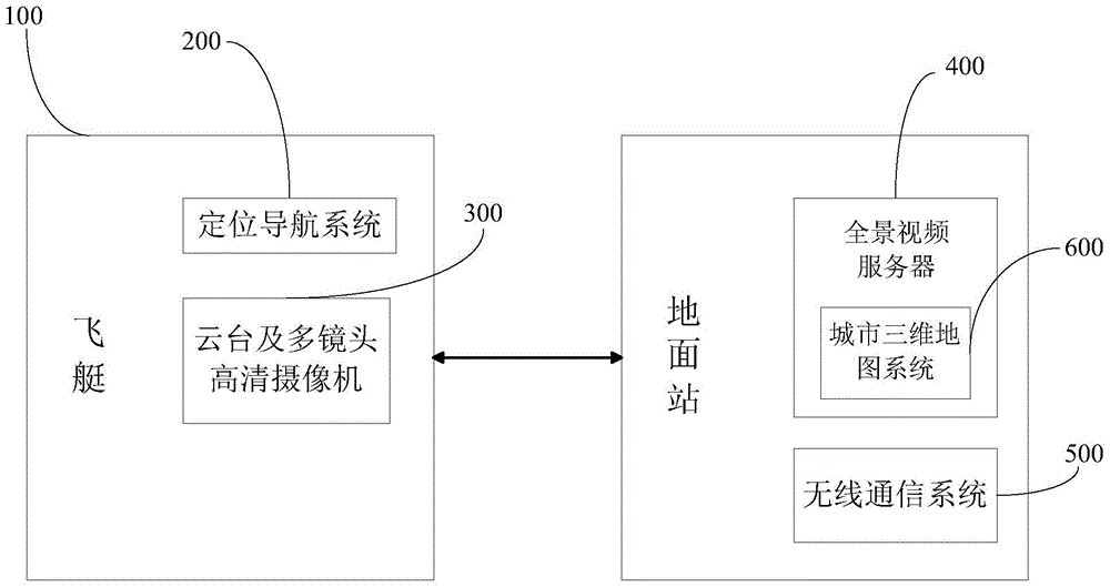
[0037] Such as Figure 1 ~ Figure 2 As shown, an aerial stereoscopic video street view system based on a navigation airship includes a rotor airship 100, and a collision sensing module 110 can be added to a plurality of protruding parts outside the capsule of the rotor airship 100 to detect collision signals.

[0038] Further, the rotor airship 100 is also provided with a power control module 120 and an ultrasonic emission sensing module 130, the ultrasonic emission sensing module 130 is used to detect obstacles around the rotor airship 100, and if an obstacle is found, the obstacle and its distan...


PUM


Abstract

Provided are an aerial stereoscopic video streetscape system based on a navigation airship and an implement method. The system acquires aerial video streetscape by a viewing mode combining automatic flying and manual flying of a navigation airship, and solves a difficulty in streetscape data acquisition and update at high efficiency and low cost. A rotor wing airship captures aerial panoramic videos, and divides layers according to a flying height and by using latitude and longitude as coordinates, thereby forming the aerial video streetscape of a city. The system has wider view and higher height, displays the stereoscopic space of the city in an omnibearing way, effectively prevents a case that current ground streetscape is restricted by lack of roads, obstruction of buildings, ground fluctuation, and blind angles, may cover any area of the city in the air, replaces static streetscape with dynamic video streetscape, and may display the real space really and dynamically in a large data bulk.

Description

technical field [0001] The invention relates to the field of aircraft, in particular to an airship-based aerial stereoscopic video street view system and an implementation method. Background technique [0002] With the development of technologies such as Internet technology and video images, street view has become a common technology for Internet maps. On the one hand, the 360-degree panoramic image is projected on the spherical coordinate system, and the user can obtain multi-dimensional visual information through operations such as mouse rotation and zooming in and out. On the other hand, video shooting through 360-degree panoramic cameras has become the mainstream of video surveillance, and panoramic stitching of multiple cameras has also been widely used. [0003] The current video street view system mostly uses street view vehicles to capture static two-dimensional data on the ground, lacking aerial observation capabilities and three-dimensional and dynamic visual effe...

Claims


Application Information

Patent Timeline
Patent Type & Authority Applications(China)
IPC IPC(8): G05D1/10H04N7/18G06F17/30G01C11/02G01C11/08
CPCG01C11/02G01C11/08G05D1/101G06F16/29H04N7/18
Inventor 修文群
Owner SHENZHEN INST OF ADVANCED TECH
Why Eureka
Try Eureka