Urban air streetscape processing system and method based on navigation airship

A processing system and airship technology, applied in the field of aircraft, can solve the problems of long period, large investment in ground acquisition methods, lack of aerial observation capabilities and 3D visual effects, etc., and achieve the effect of large field of view and height, high efficiency and low cost

Inactive Publication Date: 2016-06-29
SHENZHEN INST OF ADVANCED TECH
View PDF3 Cites 6 Cited by
  • Summary
  • Abstract
  • Description
  • Claims
  • Application Information

AI Technical Summary

Problems solved by technology

[0003] The current street view system mostly uses street view vehicles to capture two-dimensional data on the ground, lacking aerial observation capabilities and three-dimensional visual effects; and limited by the accessibility of ground roads and vehicle traffic, it is impossible to achieve full coverage of the city; in addition, street view maps require a large number of data updates Maintenance, ground collection method requires large investment, long period and high cost

Method used


Image

  • Urban air streetscape processing system and method based on navigation airship
  • Urban air streetscape processing system and method based on navigation airship
  • Urban air streetscape processing system and method based on navigation airship

Examples


Embodiment Construction

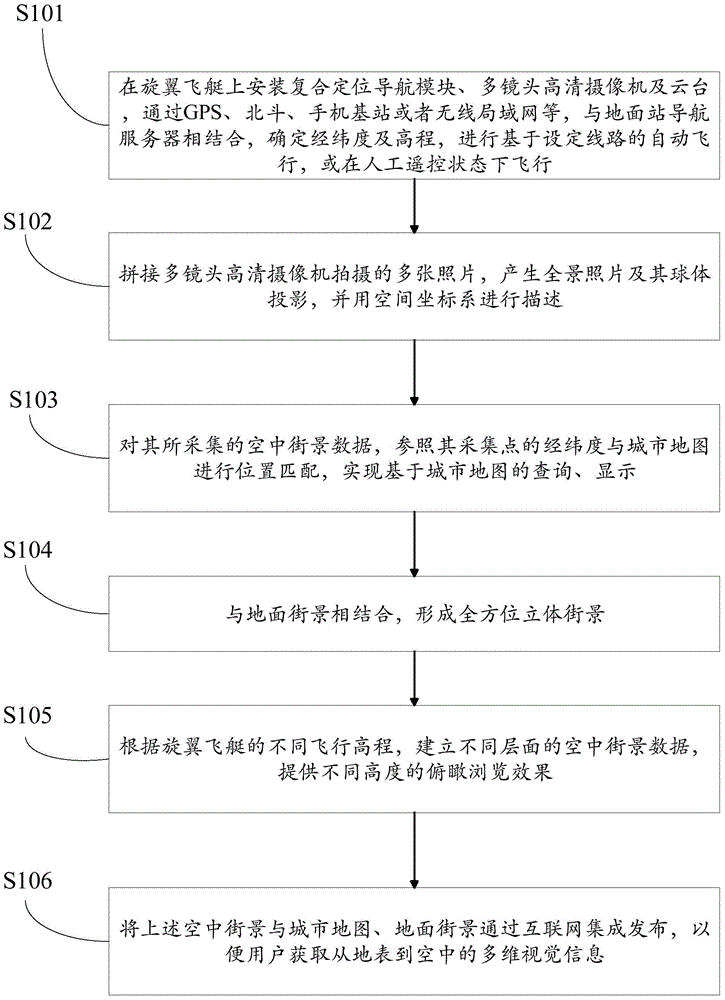
[0025] In order to make the purpose, technical solution and advantages of the present invention clearer, the present invention will be further described in detail below in conjunction with the accompanying drawings and embodiments. It should be understood that the specific embodiments described here are only used to explain the present invention, not to limit the present invention.

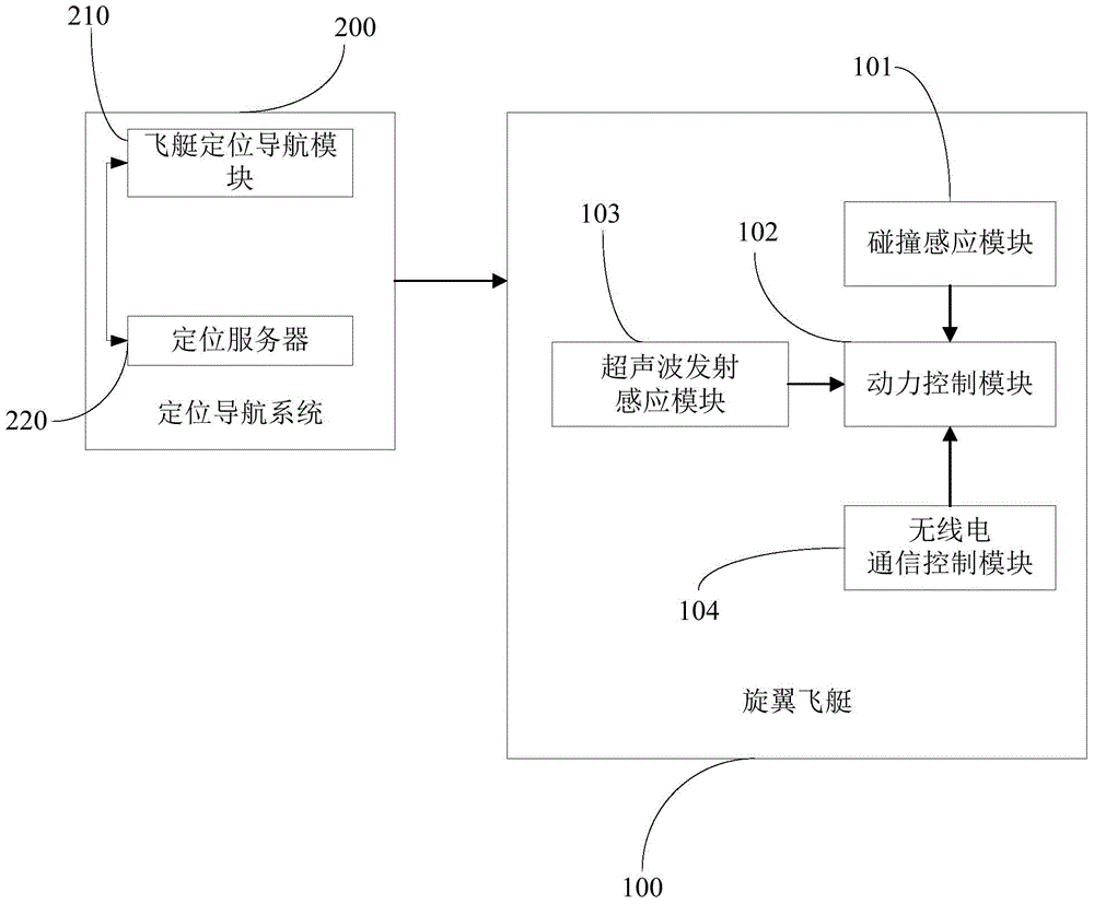
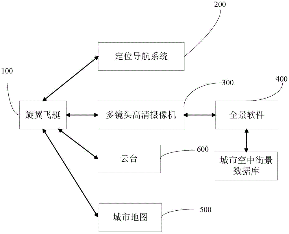
[0026] like figure 1 and figure 2 As shown, an urban air street view processing system based on a positioning airship includes a rotor airship 100, and a collision sensing module 101 can be added to a plurality of protruding parts outside the capsule of the rotor airship 100, and the collision sensing module 101 is used to detect collision signals.

[0027] Further, the rotor airship 100 is also provided with a power control module 102 and an ultrasonic emission sensing module 103, the ultrasonic emission sensing module 103 is used to detect obstacles around the rotor airship 100, and if an obst...


PUM


Abstract

The invention provides an urban air streetscape processing system and method based on a navigation airship. A view finding mode combining automatic flying and manual flying of the navigation airship is achieved and a difficulty in acquisition and updating of streetscape data is solved in a highly efficient and low-cost manner. According to the invention, an air panoramic picture is shot by the airship, and by taking the longitude and the altitude as plane coordinates, and dividing layers according heights, an urban air streetscape with a quite large view field and a quite big height is formed; urban stereo space is displayed in all directions; situations of restrictions on the current ground streetscapes imposed by multiple kinds of obstacles like roads, buildings and surface materials and of blind angles are effectively changed; and any region of a city can be covered from the air.

Description

technical field [0001] The invention relates to the field of aircraft, in particular to a navigation airship-based urban aerial street scene processing system and method. Background technique [0002] As a widely used self-elevating aircraft, the airship has the ability to suspend in the air, is easy to operate and drive, can fly in the air for a long time at low speed, has good safety performance, low operating cost, and is easy to maintain. It can be widely used in monitoring, surveying and mapping, positioning, communication and other fields. [0003] The current street view system mostly uses street view vehicles to capture two-dimensional data on the ground, lacking aerial observation capabilities and three-dimensional visual effects; and limited by the accessibility of ground roads and vehicle traffic, it is impossible to achieve full coverage of the city; in addition, street view maps require a large number of data updates Maintenance and ground collection methods re...

Claims


Application Information

Patent Timeline
Patent Type & Authority Applications(China)
IPC IPC(8): G06K9/00
CPCG06V20/176
Inventor 修文群
Owner SHENZHEN INST OF ADVANCED TECH
Why Eureka
Try Eureka