Channel drainage basin renovation planning simulating method and system based on OSG

A planning simulation and watershed technology, applied in image data processing, special data processing applications, instruments, etc., can solve problems such as inability to combine landform features, unable to meet the needs of visual aided decision-making in channel watershed improvement planning, etc.

Active Publication Date: 2016-07-13
INST OF GEOGRAPHICAL SCI & NATURAL RESOURCE RES CAS
View PDF5 Cites 14 Cited by
  • Summary
  • Abstract
  • Description
  • Claims
  • Application Information

AI Technical Summary

Problems solved by technology

[0005] However, in the current gully watershed renovation process, the renovation experts need to master the method of extracting geomorphic features by professional ARCGIS software, but each extraction operation can only obtain one type of geomorphic features and present them in a planar area. Manual identification; in the land leveling design of the gully, the remediation experts need to use professional software such as Southern CASS to manually design the fill height to calculate the earthwork volume, and it is impossible to combine the landform characteristics into the land leveling design
[0006] Therefore, the existing 3D watershed simulation cannot meet the needs of visual aided decision-making in channel watershed improvement planning.

Method used


Image

  • Channel drainage basin renovation planning simulating method and system based on OSG
  • Channel drainage basin renovation planning simulating method and system based on OSG
  • Channel drainage basin renovation planning simulating method and system based on OSG

Examples


Embodiment 1

[0045] In this embodiment, an OSG-based simulation method for channel watershed improvement planning is introduced.

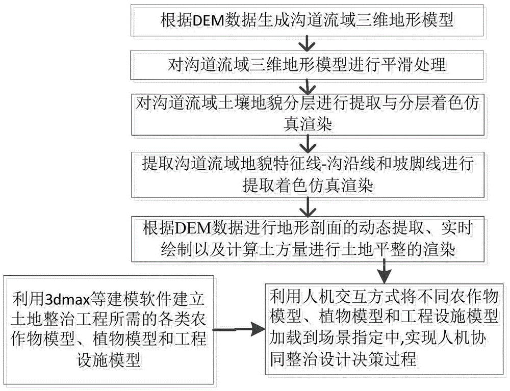
[0046] Such as figure 1 As shown, the method includes the following nine steps.

[0047] 1. Establish a three-dimensional topographic model of the small watershed of the channel, specifically:

[0048] In this embodiment, the original data used to construct the three-dimensional terrain model is CAD data, but the CAD data is not vivid enough for three-dimensional simulation, so the present invention processes it. First, use the grid interpolation method of ArcGIS to segment and sample the original CAD topographic map in DWG format to generate digital elevation model (DEM, namely DigitalElevationModel) data, export the DEM data of block topography to save in dbf format, and save the dbf format The data file is converted into a cross-platform readable txt format file, and the number of rows and columns of the DEM data of the block terrain is obtained from the t...

Embodiment 2

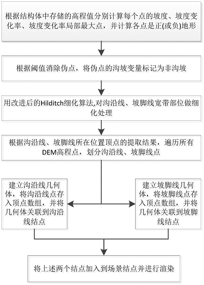
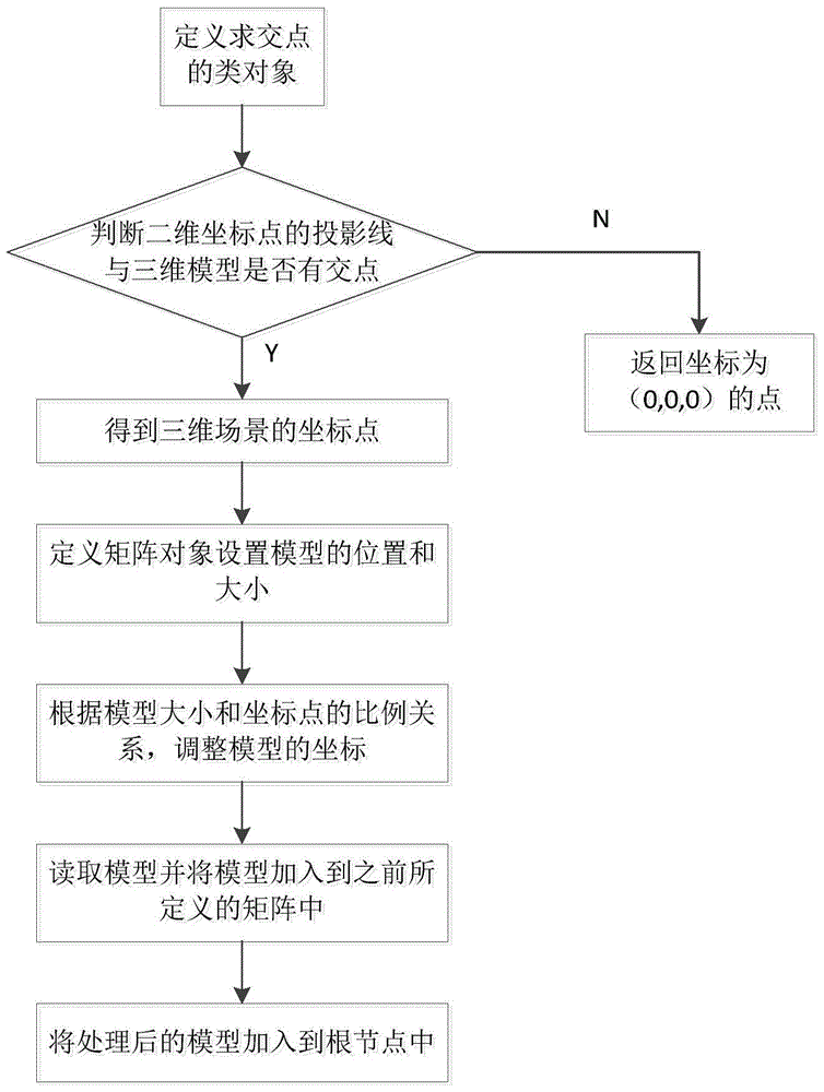
[0072] In this embodiment, the present invention provides a system for performing the above method. Such as Figure 4 As shown, the present invention utilizes the cross-platform C++ graphical user interface library QT for system integration to realize real-time interactive operation, dynamic cutting and rendering. The system specifically includes: a function layer, a model layer, and a data layer. Among them, the data layer stores basic data, including: digital elevation model data, geomorphic feature data, calculation results of terrain profile analysis, and model data; the model layer stores various types of crops, plants, farmland, and engineering facility models created by modeling software; The functional layer is the core module of the simulation system, which extracts, recognizes and calculates the topographic features of the 3D terrain model and renders them through the OSG engine.


PUM


Abstract

The invention provides a channel drainage basin renovation planning simulating method and system based on an OSG. The method comprises the following steps that a three-dimensional channel drainage basin terrain model based on a digital elevation model (DEM) is constructed, the soil landform layers and the landform characteristic lines of the channel drainage basin are extracted, recognized and visually simulated, the two-dimensional section and the three-dimensional section of the channel drainage basin terrain are dynamically extracted and drawn and rendered in real time, land levelling rendering is performed through the earth volume calculated by the DEM, multiple crop and plant models, basic farmland farming modes and engineering facility models are built, and dynamic loading, replacing, moving and deleting of the models are controlled through a man-machine interaction mechanism. According to the method, the problems of extracting, recognizing and visual stimulating on the important landform features and the soil landform layers of the channel drainage basin and extracting and drawing on the terrain sections are effectively solved, the true conditions of the natural terrain of the channel drainage basin are presented, and a visualization decision making support method for performing man-machine coordination design in the channel drainage basin renovation planning process is supplied.

Description

technical field [0001] The invention belongs to the field of agricultural planning simulation, and in particular relates to an OSG-based simulation method and system for ditch watershed improvement planning. Background technique [0002] Ditch watershed improvement project is an important form of land consolidation, an effective means of increasing cultivated land and balance of cultivated land occupation and compensation, and also an important farmland water conservancy measure for flood control, sediment reduction, and water and soil conservation. Due to the comprehensive influence of factors such as natural conditions, land use status, and social and economic development levels, the investment and risks of the canal improvement project are also different. How to avoid the high risk of the improvement project and promote the sustainable use of land, scientifically plan and formulate A viable channel watershed remediation suitability scheme is critical. [0003] In recent ...

Claims


Application Information

Patent Timeline
Patent Type & Authority Applications(China)
IPC IPC(8): G06F17/50G06T17/05
CPCG06F30/367G06T17/05
Inventor 刘彦随张莉崔亚超文戈王介勇李裕瑞
Owner INST OF GEOGRAPHICAL SCI & NATURAL RESOURCE RES CAS
Why Eureka
Try Eureka