
Small satellite constellation remote sensing system model based on unmanned aerial vehicle assisted coverage

A technology of satellite constellation and system model, which is applied in the field of remote sensing of satellites and UAVs, can solve the problems of delayed transmission of remote sensing information, reduction of sensor monitoring range, and large time intervals of information transmission, so as to overcome the problem of remote sensing gaps and remote sensing The effect of limited range and improved remote sensing resolution

Active Publication Date: 2016-12-07
HARBIN INST OF TECH SHENZHEN GRADUATE SCHOOL
View PDF2 Cites 10 Cited by
  • Summary
  • Abstract
  • Description
  • Claims
  • Application Information

AI Technical Summary

Problems solved by technology

[0006] 3. Defects of Satellite Remote Sensing Technology
[0008] 1) high cost
If small satellites can realize real-time observation of hotspots, that is, zero revisit period, many satellites will be needed, and the license cost and launch cost are relatively high, which will be a serious waste of resources.
[0009] 2) poor timeliness
The development cycle, launch cycle, and revisit cycle are all relatively long. In addition, the information transmission time interval will cause a lot of delayed transmission of remote sensing information.
[0010] 3) Poor mobility
In the event of emergencies or serious disasters (such as large-scale forest fires), when real-time monitoring of hotspot areas is required, small satellites cannot complete the dispatch in time, and cannot achieve real-time monitoring
[0011] 4) Limited by the influence of deep space environment
[0012] 5) Waste of track resources
Orbital resources are scarce. With the increasing demand of people, the number of launched satellites has increased sharply, resulting in a serious shortage of orbital resources.
[0013] 6) There are gaps in remote sensing
[0014] 4. Insufficiency of UAV remote sensing
Due to the influence of flight altitude, the monitoring range of the on-board sensors is greatly reduced for satellites
[0017] 2) Limited functionality
Sensitive areas cannot be found, and due to limited payload capacity, only simple image capture tasks can be completed

Method used


Image

  • Small satellite constellation remote sensing system model based on unmanned aerial vehicle assisted coverage
  • Small satellite constellation remote sensing system model based on unmanned aerial vehicle assisted coverage
  • Small satellite constellation remote sensing system model based on unmanned aerial vehicle assisted coverage

Examples


Embodiment Construction

[0045] The present invention will be further described below in conjunction with the accompanying drawings and specific embodiments.

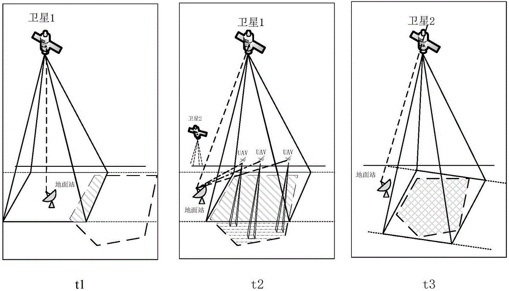
[0046] UAV and small satellite cooperation mechanism such as figure 1 As shown in , the members of the constellation will have different trajectories when passing through the target area, and there will be a certain time interval. Judging from the coverage at time t1 and t2, satellite 1 passes the target area before satellite 2 arrives, but cannot fully cover the target area. At this time, we can use drones to assist remote sensing. Before the arrival of time t3, we will use drones to complete the remote sensing of uncovered areas.

[0047] The algorithm flow of small satellite and UAV cooperation is as follows:

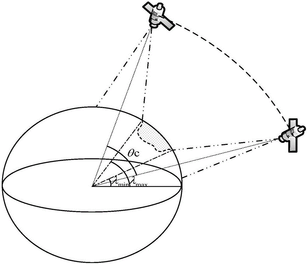
[0048] The first step: according to the constellation parameters (including the number of satellites n s and the number of orbits and the orbital parameters V(a, θ, e, ω, Ω, f), and the coordinate set C of the boundary point of the t...


PUM


Abstract

The invention relates to the technical field of satellite and unmanned aerial vehicle remote sensing, in particular to a small satellite constellation remote sensing system model based on unmanned aerial vehicle assisted coverage. Based on an unmanned aerial vehicle and small satellite cooperation mechanism, an unmanned aerial vehicle and small satellite cooperation constraint model is provided, and the unmanned aerial vehicle and small satellite cooperation mechanism is analyzed under the constraint model. A coverage performance analysis algorithm is provided, and the coverage performances under different constellations are compared and analyzed. The small satellite constellation remote sensing system model improves the coverage performance of independent remote sensing, overcomes the shortcoming of small satellite remote sensing gaps, can improve the remote sensing resolution, and meanwhile, can lower the remote sensing cost. In addition, small satellite and unmanned aerial vehicle cooperation also solves the problem of limited remote sensing range of an unmanned aerial vehicle.

Description

technical field [0001] The invention relates to the technical field of satellite and UAV remote sensing, in particular to a small satellite constellation remote sensing system model based on UAV-assisted coverage. Background technique [0002] 1. Satellite remote sensing technology [0003] The combination of space technology and photoelectric detection technology gave birth to modern aerospace remote sensing technology. From the beginning of the space age, the space remote sensing technology, which uses various sensors carried by spacecraft to observe the earth to obtain all-round and all-weather geospatial information, has been called one of the key points of competition and development of all countries in the world. Because the satellite remote sensing observation platform has the characteristics of long running time, stable flight, large amount of information, and the ability to periodically repeat earth observation and update data in a timely manner, the satellite remo...

Claims


Application Information

Patent Timeline
Patent Type & Authority Applications(China)
IPC IPC(8): G06F17/50
CPCG06F30/367
Inventor 杨志华苏敏刘振涛金豪杰
Owner HARBIN INST OF TECH SHENZHEN GRADUATE SCHOOL
Learn More