How to use unity3d terrain data in direct3d 11 environment

A technology of terrain data and terrain, applied in the field of data processing and display of Direct3D11, can solve problems such as loss of texture information

Active Publication Date: 2018-11-09
PLA UNIV OF SCI & TECH
View PDF4 Cites 0 Cited by
  • Summary
  • Abstract
  • Description
  • Claims
  • Application Information

AI Technical Summary

Problems solved by technology

The terrain model produced by such an efficient and convenient terrain editor can only be used in the Unity3D environment. Although the existing plug-in can be used to export the vertex position information of the terrain model, only the vertex position information is far from enough. These data are in Direct3D Only the ups and downs of the terrain can be seen in the environment, and all texture information is lost

Method used


Image

  • How to use unity3d terrain data in direct3d 11 environment
  • How to use unity3d terrain data in direct3d 11 environment
  • How to use unity3d terrain data in direct3d 11 environment

Examples


Embodiment Construction

[0065] A further detailed description will be made below in conjunction with the accompanying drawings and embodiments of the present invention:

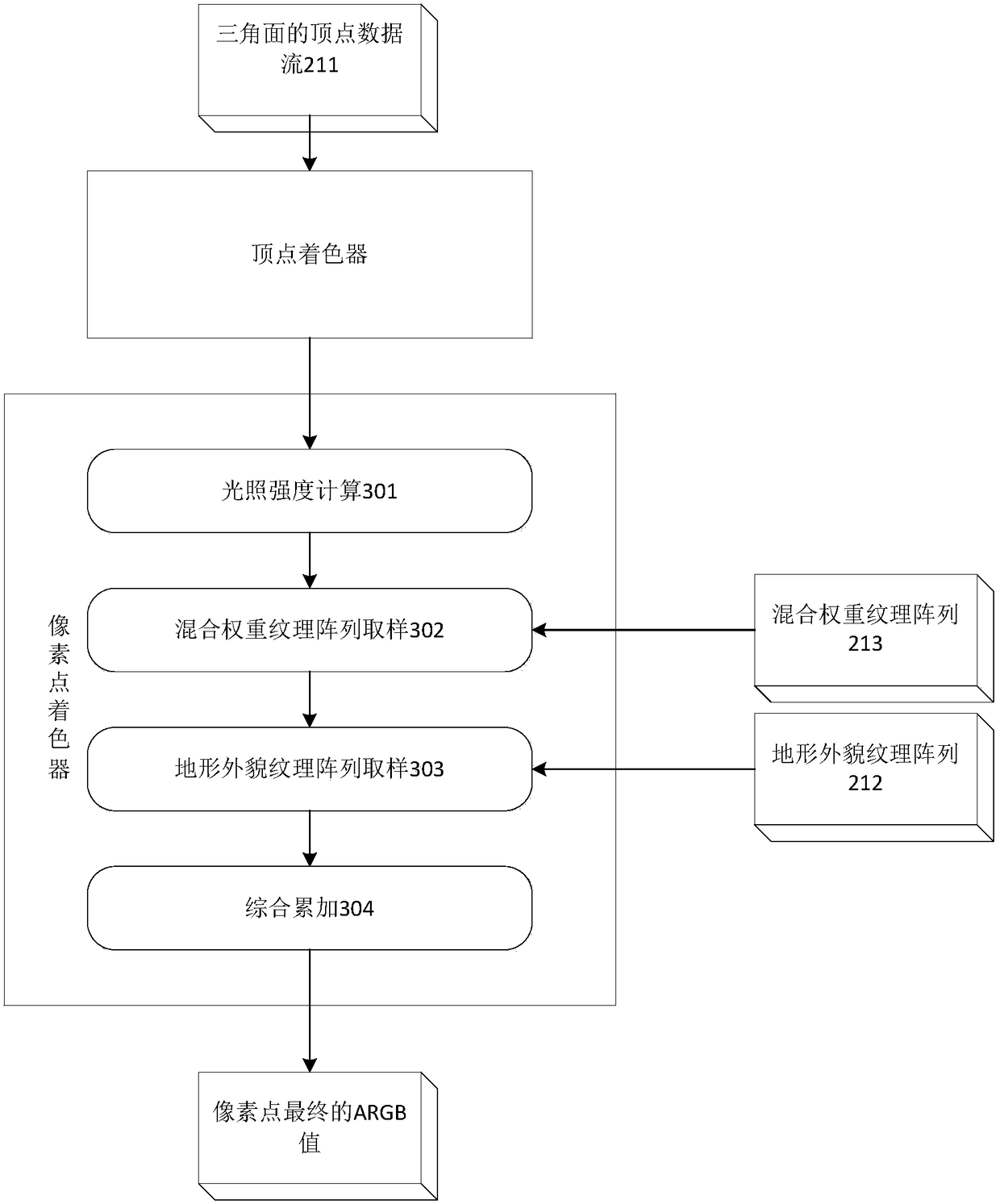
[0066] Firstly, the concept of "terrain grid row-based access order" is explained. Unity3D uses a right-handed coordinate system. Take us standing in the center of the terrain as an example, the direction of the X axis is to the right, the direction of the Y axis is upward, and the direction of the Z axis is backward. To access terrain grids according to the "terrain grid row-based access order", that is, start from the farthest row of terrain grids in front, visit from left to right, and then visit the second farthest row, so row by row, from front to After that, until the furthest line after the access is complete.

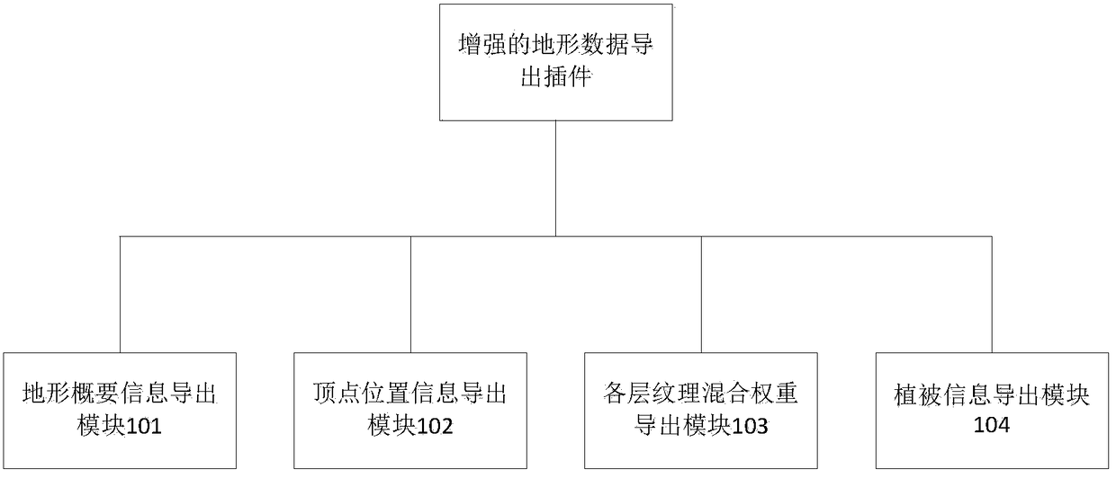
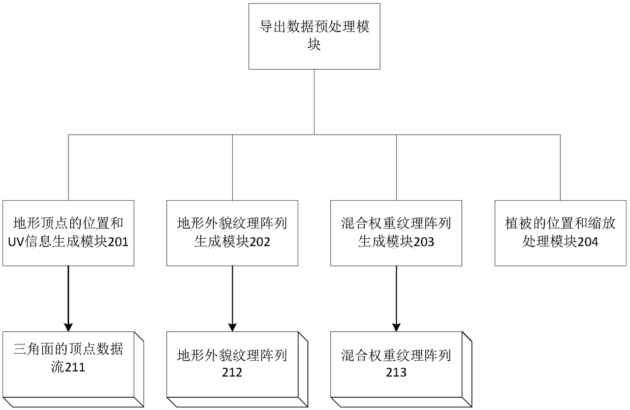
[0067] The following is a detailed introduction to the work done by each module of the export plug-in:

[0068] Summary information export module 101: The exported data includes the size of the terrain on the X-axis...


PUM


Abstract

The invention provides a use method of Unity3D terrain data in the Direct3D 11 environment. Enhanced Unity3D terrain export plug-in comprises a plurality of export submodules. A terrain vertex position and UV information generation module reads terrain vertex data exported by an export module, and a corresponding geometrical triangular face is constructed. A terrain appearance texture array generation module reads a required terrain appearance texture file according to information of a texture set in the export module, and a Direct3D 11 terrain appearance texture array is generated. A blend weight texture generation module generates a Direct3D 11 texture including texture blend weight information in the texture set according to the data exported by the export module. A vegetation position and scaling processing module sets three-dimensional space coordinates of plants in a scene according to vegetation information exported by the export module and conducts size scaling adjustment on plant surface patches. A pixel coloring device calculates light of each pixel on a screen on the basis of three-dimensional rendering element resources, texture samples are mixed in the terrain appearance texture array, and an exported terrain is displayed in the Unity3D 11 rendering environment.

Description

[technical field] [0001] The invention relates to the technical field of computer software, in particular to a Direct3D 11 data processing and display method. [Background technique] [0002] In the prior art, when developing a 3D game or designing 3D simulation software, it is often necessary to load a terrain model into the scene for rendering. Taking the engines developed based on the underlying Direct3D technology as an example, the conventional way to load terrain in these engines is to first use 3D modeling software such as 3DMax to model the terrain, generate the vertex data of the terrain, and paste the texture bitmap ; Then export the data that Direct3D can recognize and use (Direct3D 9 or previous versions use X format files, and Direct3D 10 uses sdkmesh format files). [0003] When using 3DMax software to build terrain, in addition to adjusting the position of each vertex in the terrain model, it is also necessary to use graphics processing software such as PS to ...

Claims


Application Information

Patent Timeline
Patent Type & Authority Patents(China)
IPC IPC(8): G06T17/05
CPCG06T17/05G06T2200/04
Inventor 钱进费建芳黄小刚程小平
Owner PLA UNIV OF SCI & TECH
Why Eureka
Try Eureka