MODIS (moderate resolution imaging spectroradiometer) satellite synchronous monitoring method for cyanobacterial bloom and aquatic vegetation in eutrophic lakes

A technology for cyanobacterial blooms and eutrophication, applied in the field of remote sensing, can solve problems such as affecting the accuracy of daily remote sensing monitoring of cyanobacterial blooms and being unable to adapt to the temporal and spatial changes of aquatic plants.

Active Publication Date: 2017-01-11
NANJING INST OF GEOGRAPHY & LIMNOLOGY
View PDF6 Cites 13 Cited by
  • Summary
  • Abstract
  • Description
  • Claims
  • Application Information

AI Technical Summary

Problems solved by technology

At this time, the traditional daily remote sensing monitoring method of cyanobacterial blooms in Taihu Lake will misjudge aquatic plants as cyanobacterial blooms, which seriously affects the daily remote sensing monitoring accuracy of cyanobacterial blooms; in addition, in order to reduce the adverse effects of a large number of aquatic plants on shipping, Relevant local departments will regularly harvest, resulting in artificial changes in the aquatic plant area; in

Method used


Image

  • MODIS (moderate resolution imaging spectroradiometer) satellite synchronous monitoring method for cyanobacterial bloom and aquatic vegetation in eutrophic lakes
  • MODIS (moderate resolution imaging spectroradiometer) satellite synchronous monitoring method for cyanobacterial bloom and aquatic vegetation in eutrophic lakes
  • MODIS (moderate resolution imaging spectroradiometer) satellite synchronous monitoring method for cyanobacterial bloom and aquatic vegetation in eutrophic lakes

Examples


Embodiment Construction

[0045] In order to better understand the technical content of the present invention, specific embodiments are given together with the attached drawings for description as follows.

[0046] Aspects of the invention are described in this disclosure with reference to the accompanying drawings, which show a number of illustrated embodiments. Embodiments of the present disclosure are not necessarily intended to include all aspects of the invention. It should be understood that the various concepts and embodiments described above, as well as those concepts and embodiments described in more detail below, can be implemented in any of a number of ways, which should be the concepts and embodiments disclosed by the present invention and not Not limited to any implementation. In addition, some aspects of the present disclosure may be used alone or in any suitable combination with other aspects of the present disclosure.

[0047] This embodiment takes Taihu Lake as an example to further ...


PUM


Abstract

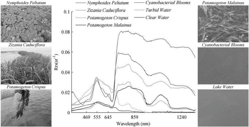
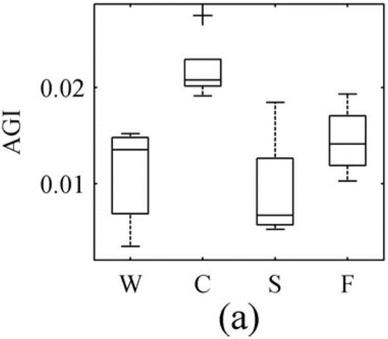
The invention provides an MODIS (moderate resolution imaging spectroradiometer) satellite synchronous monitoring method for cyanobacterial bloom and aquatic vegetation in eutrophic lakes. The MODIS satellite synchronous monitoring method includes combining spectral characteristics of the cyanobacterial bloom, the submerged vegetation and floating-leaf/emergent vegetation with one another on the basis of field measured spectral data and creating alga and grass indexes (AGI); combining turbid water indexes (TWI) and floating alga indexes (FAI) with one another and determining basic classification processes; determining classification thresholds for the AGI, the TWI and the FAI on the basis of historically acquired MODIS satellite data; ultimately completely constructing classification decision trees and synchronously monitoring the cyanobacterial bloom, the submerged vegetation and the floating-leaf/emergent vegetation on MODIS satellite images. Alga-containing water and grass-containing water can be separated from each other by the aid of the alga and grass indexes (AGI). High-turbidity water can be identified by the aid of the turbid water indexes (TWI), and the submerged vegetation and the floating-leaf/emergent vegetation can be differentiated from each other by the aid of the floating alga indexes (FAI). The MODIS satellite synchronous monitoring method has the advantage that interannual and inter-monthly variation laws and spatial distribution of the cyanobacterial bloom, the submerged vegetation and the floating-leaf/emergent vegetation in the eutrophic lakes can be accurately acquired on the basis of the MODIS satellite synchronous monitoring method.

Description

technical field [0001] The invention relates to the technical field of remote sensing, in particular to a MODIS satellite high-precision synchronous monitoring method for cyanobacteria blooms and aquatic vegetation in large-scale eutrophic lakes. Background technique [0002] The algal blooms caused by algae blooms are an important feature of lake water eutrophication (Kong Fanxiang and Gao Guang, 2005), and my country has become one of the countries with the most serious outbreaks of cyanobacteria blooms and the widest distribution in the world (Wu Qinglong et al., 2008) . Satellite remote sensing has the characteristics of rapidity, periodicity, and large range, and has become an indispensable technical means for monitoring, forecasting and early warning of cyanobacteria blooms in lakes (Pandel and Ma Ronghua, 2008). Since 2007, satellite remote sensing monitoring of cyanobacterial bloom area in Taihu Lake has basically realized operational operation (Ma Ronghua et al., 20...

Claims


Application Information

Patent Timeline
IPC IPC(8): C02F3/32G01N21/25
CPCC02F3/32C02F3/322C02F2103/007G01N21/25
Inventor 张玉超梁其椿马荣华
Owner NANJING INST OF GEOGRAPHY & LIMNOLOGY
Why Eureka
Try Eureka