Check patentability & draft patents in minutes with Patsnap Eureka AI!

GIS-based insurance relief command auxiliary decision system

A technology that assists in decision-making and disaster situations, and is applied in the fields of instruments, finance, and data processing applications. It can solve the problems that the command center cannot intuitively and real-time understand the progress of rescue and claim settlement, and cannot flexibly dispatch personnel.

Inactive Publication Date: 2017-01-18
SUZHOU HUAXING YUANCHUANG TECH CO LTD
View PDF5 Cites 14 Cited by
  • Summary
  • Abstract
  • Description
  • Claims
  • Application Information

AI Technical Summary

Problems solved by technology

[0006] The technical problem to be solved by the present invention is to provide a GIS-based insurance and disaster relief command auxiliary decision-making system. The command center cannot intuitively understand the progress of rescue claims in real time, and cannot flexibly conduct personnel scheduling.

Method used


Image

  • GIS-based insurance relief command auxiliary decision system

Examples


Embodiment Construction

[0046] In order to illustrate the present invention more clearly, the present invention will be further described below in conjunction with preferred embodiments and accompanying drawings. Similar parts in the figures are denoted by the same reference numerals. Those skilled in the art should understand that the content specifically described below is illustrative rather than restrictive, and should not limit the protection scope of the present invention.

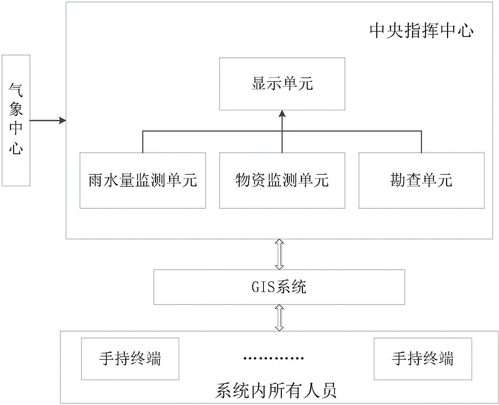
[0047] The invention discloses a GIS-based insurance and disaster relief command auxiliary decision-making system, which comprises: a rainwater amount detection unit, a material monitoring unit and a survey unit. According to the real-time water and rain situation information released by the Meteorological Bureau, the rainwater monitoring unit uses the GIS system to display the current water and rain situation and hydrological information in real time under different geographical conditions, and judges whether to issue a di...


PUM


Abstract

The invention discloses a GIS-based insurance relief command auxiliary decision system comprising a rainwater monitoring unit which is used for displaying the current rainwater situation and hydrological information in real time under different geographical conditions through a GIS system according to the real-time rainwater situation information released by the weather bureau and judging whether or not to release a disaster warning according to a preset threshold, a material monitoring unit which is used for acquiring the storage and loss situation of insured materials, displaying the current material situation in different storage places through the GIS system and judging whether or not to release a material disaster warning according to a preset threshold, and an exploration unit which is used for designating business personnel closest to an affected area to perform exploration and assess the loss based on the disaster warning and / or the material warning. The technical scheme of the invention is based on the GIS system, field disaster information received from a mobile phone client and information obtained from a third-party platform such as meteorological information and hydrological information are comprehensively displayed to a command side, and front-end workers are scheduled according to the information.

Description

technical field [0001] The invention relates to a command auxiliary decision-making system, in particular to a GIS-based information collection and auxiliary decision-making system for insurance and disaster relief. Background technique [0002] At present, the basic network system for emergency rescue and disaster relief has made great progress, integrated automation is gradually popularized and applied, and emergency management is also supported by a part of the system, which has made great contributions to insurance and disaster relief. However, when a major disaster occurs in the existing system, due to the large number of participants and the wide distribution of regions, it is difficult for the commander to grasp the disaster relief progress and on-site conditions, and it is impossible to realize data sharing among multiple parties and flexible scheduling of personnel, which reduces the work efficiency and delay of insurance disaster relief. disaster relief time. [0...

Claims


Application Information

Patent Timeline
IPC IPC(8): G06Q10/06G06Q40/08G06Q50/26
CPCG06Q10/0637G06Q40/08G06Q50/26
Inventor 陈文源谢红兵张红强刁良海顾玲娣
Owner SUZHOU HUAXING YUANCHUANG TECH CO LTD
Features
  • R&D
  • Intellectual Property
  • Life Sciences
  • Materials
  • Tech Scout
  • Unparalleled Data Quality
  • Higher Quality Content
  • 60% Fewer Hallucinations
Learn More