GPS based path diagram drafting method and system

A route map and route technology, applied in the field of surveying and mapping, can solve problems such as low efficiency, low accuracy of route map drawing, and tedious work, and achieve the effect of reducing the tediousness of work, improving the accuracy of drawing, and improving work efficiency.

Active Publication Date: 2017-02-22
BEIJING DAOPOWER +1
View PDF8 Cites 1 Cited by
  • Summary
  • Abstract
  • Description
  • Claims
  • Application Information

AI Technical Summary

Problems solved by technology

[0004] However, the measurement data obtained by each designer may come from different GPS surveying and mapping equipment, and the data formats of different surveying and mapping equipment are not uniform. If they are processed in the same format, it will inevitably cause the most basic data errors.
Moreover, due to the existence of data errors, designers need to perform a large number of operations on each drawn element when deleting or adjusting, resulting in low accuracy of drawing the path map, and the work is cumbersome and inefficient

Method used


Image

  • GPS based path diagram drafting method and system
  • GPS based path diagram drafting method and system

Examples


Embodiment Construction

[0037] The following will clearly and completely describe the technical solutions in the embodiments of the application with reference to the drawings in the embodiments of the application. Apparently, the described embodiments are only some of the embodiments of the application, not all of them. Based on the embodiments in this application, all other embodiments obtained by persons of ordinary skill in the art without making creative efforts belong to the scope of protection of this application.

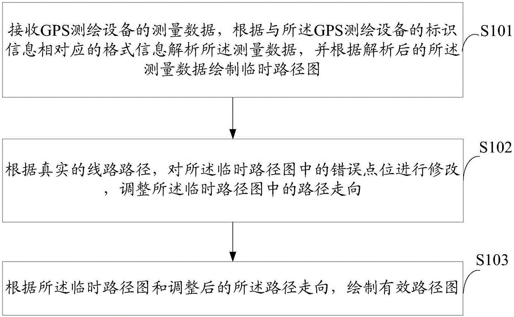
[0038] see figure 1 A schematic flowchart of a method for drawing a route map based on GPS disclosed by an embodiment of the present invention is shown.

[0039] Depend on figure 1 It can be seen that the method includes:

[0040] S101: Receive measurement data from a GPS surveying and mapping device, analyze the measurement data according to format information corresponding to the identification information of the GPS surveying and mapping device, and draw a temporary route map a...


PUM


Abstract

The invention discloses a GPS based path diagram drafting method and system. Measuring data of a GPS plotting device is received, the measuring data is parsed according to format information corresponding to identification information of the GPS plotting device, and a temporary path diagram is drafted according to the parsed measuring data; according to a real path, error points in the temporary path diagram are modified, and the path direction in the temporary path diagram is adjusted; and according to the temporary path diagram and the adjusted path direction, an effective path diagram is drafted. According to technical schemes of the invention, the measuring data can be parsed by selecting the format information corresponding to the identification information of the GPS plotting device instead of being processed in a unified format, data errors can be reduced, the drafting accuracy of the path diagram is improved, work is less tedious, and the working efficiency is improved.

Description

technical field [0001] The present application relates to the technical field of surveying and mapping, and more particularly relates to a GPS-based route drawing method and system. Background technique [0002] With the rapid development of economic construction and more and more road construction projects, the speed and accuracy of road measurement are particularly important. As a high-tech global satellite positioning technology, GPS has real-time, fast, all-weather, high-precision, high- Notable features such as efficiency and simple operation have been widely used in many industries such as power grids, construction, and transportation. [0003] At present, GPS-based real-time dynamic positioning technology is more and more applied to surveying and mapping technologies such as route map drawing. The existing route map drawing method mainly uses the designer to extract the correct geographical coordinate information according to the measurement data of the corresponding...

Claims


Application Information

Patent Timeline
Patent Type & Authority Applications(China)
IPC IPC(8): G01S19/38
CPCG01S19/38
Inventor 陈宝珍隗刚刘平尚曲京武张战运齐聪孙敏杰
Owner BEIJING DAOPOWER
Why Eureka
Try Eureka