Virtual reality technology-based real environment mapping system

A virtual reality technology and real environment technology, applied in the field of real environment mapping system, can solve problems such as the inability to reproduce the earth environment, climate, and geographical information, do not involve accurate rendering of environmental parameters, and cannot process other environmental parameters, so as to save mobile energy The effect of saving cost, saving individual time cost, and saving public transportation resources

Inactive Publication Date: 2017-05-10
TONGJI UNIV
View PDF9 Cites 17 Cited by
  • Summary
  • Abstract
  • Description
  • Claims
  • Application Information

AI Technical Summary

Problems solved by technology

[0004] (1) "A method for generating an environment map" (Application No.: 201080058471.8) relates to a method for generating an environment map representing illumination information of a real environment, but this invention only involves illumination and brightness information, and cannot be used for other Environmental parameters are treated accordingly, which cannot provide users with a sense of reality
[0005] (2) "Method and system for using real data to drive a simulated virtual environment" (application number: 01210495604.9) describes the real-time rendering of information such as human actions, object shapes, and positions in a small space into a virtual reality environment method and processing pipeline, the invention does not involve environmental parameters, and cannot truly reproduce the earth's environment, climate, and geographic information
[0006] (3) "A method for constructing a virtual street view map" (Application No.: 201610034133.X) describes a method for importing relevant information into an existing panoramic map, but this invention does not involve accurate rendering of environmental parameters
For a long time, the movement of human beings in space has been limited by the spatial dimension, and two people in different places at the same time will not be able to complete instant communication without the help of "tools" in a broad sense

Method used


Image

  • Virtual reality technology-based real environment mapping system
  • Virtual reality technology-based real environment mapping system
  • Virtual reality technology-based real environment mapping system

Examples


Embodiment Construction

[0041] The present invention will be described in detail below in conjunction with the accompanying drawings and specific embodiments. This embodiment is carried out on the premise of the technical solution of the present invention, and detailed implementation and specific operation process are given, but the protection scope of the present invention is not limited to the following embodiments.

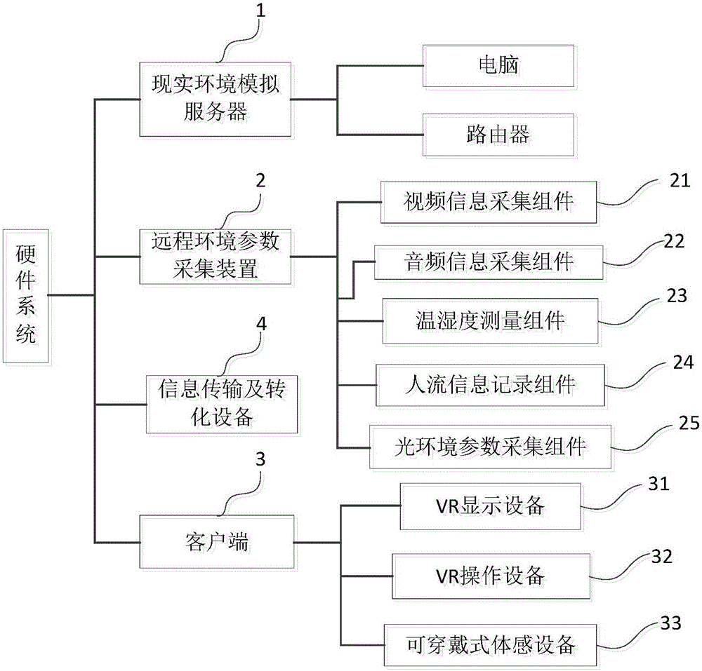
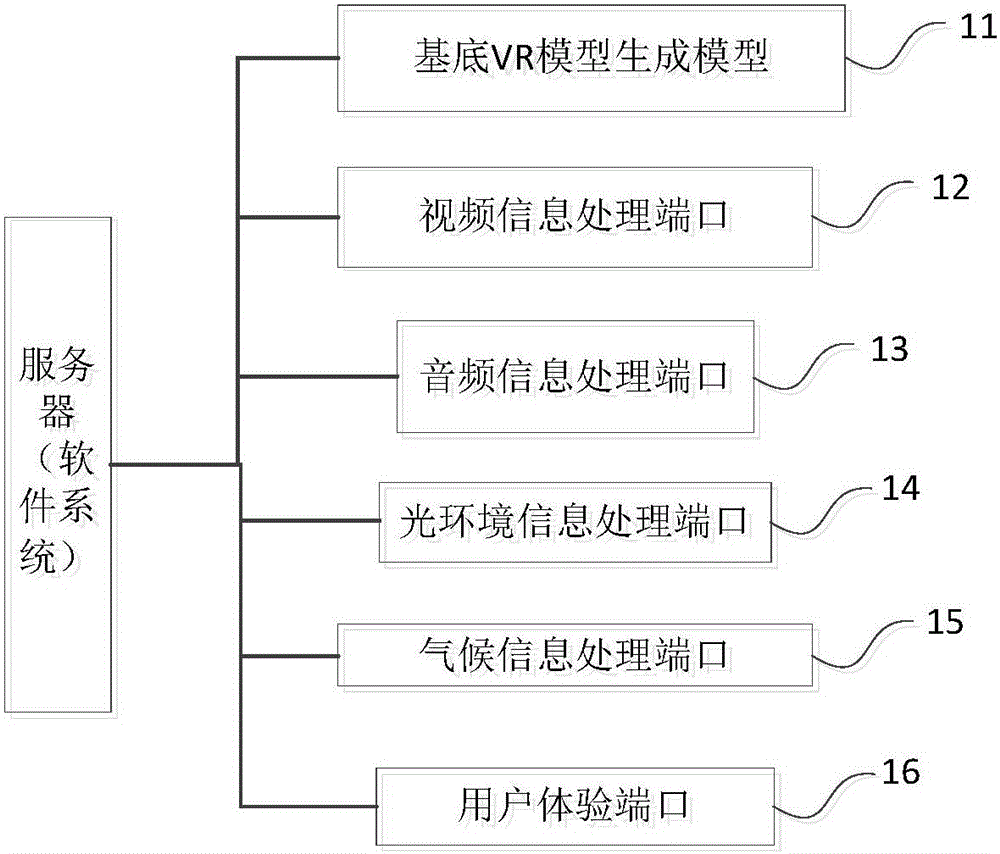
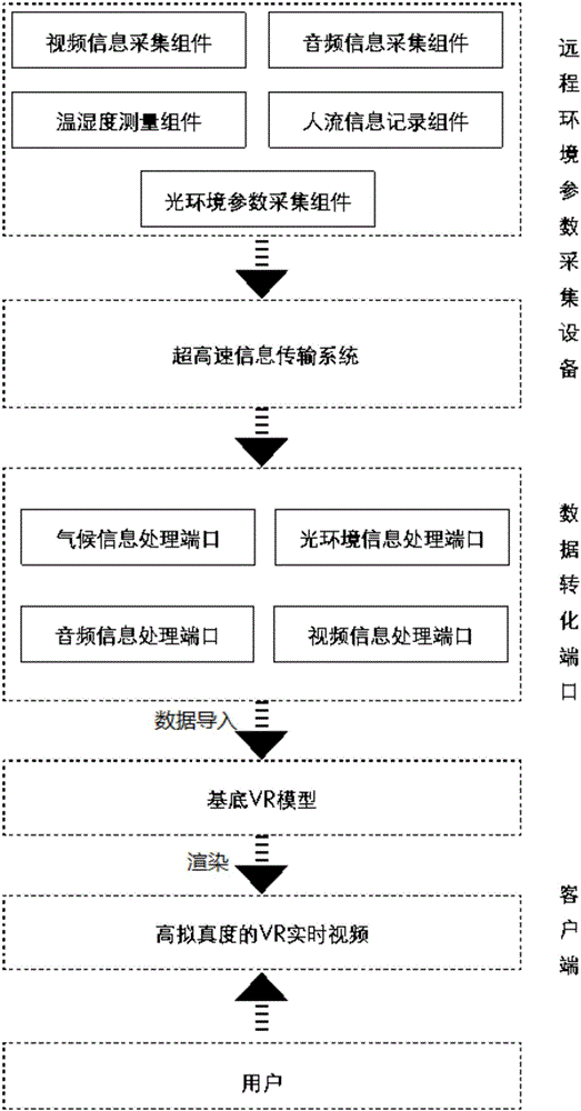
[0042] like figure 1 , image 3 As shown, this embodiment provides a real environment mapping system based on virtual reality technology, including a real environment simulation server 1, a remote environment parameter acquisition device 2, information transmission and conversion equipment 4, and a client 3, wherein the real environment simulation server 1 is used to generate a virtual environment model with accurate mapping of real environment parameters, which is a set of equipment for receiving and processing real-time information at high speed, including but not limited to comput...


PUM


Abstract

The invention relates to a virtual reality technology-based real environment mapping system. The system comprises a real environment simulation server used for generating a virtual environment model with real environment parameter accurate mapping, a remote environment parameter acquisition apparatus used for acquiring real-time environment parameter information required by the virtual environment model, an information transmission and conversion device used for realizing communication between the real environment simulation server and the remote environment parameter acquisition apparatus, and transmitting the real-time environment parameter information to the real environment simulation server, and a wearable device connected with the real environment simulation server and used for generating a VR technology-based virtual environment according to the virtual environment model so as to realize interaction with a user, wherein the real-time environment parameter information includes real-time video information, real-time audio information, real-time climate information and real-time light environment parameter information. Compared with the prior art, the system has the advantages of strong sense of reality, effectively reduced mobile cost and the like.

Description

technical field [0001] The invention relates to a real environment mapping system, in particular to a real environment mapping system based on virtual reality technology. Background technique [0002] As a tool for human beings to understand and describe the world, maps have been continuously accumulated and developed for a long time. The early maps were limited by the characteristics of the carrier, and the amount of information that a single map could represent was small, and it was often necessary to rely on the adjustment of the drawing scale to describe the topography and landforms at different scales. With the development of information technology, electronic maps represented by Google Earth have shown considerable development. Electronic maps can easily and seamlessly display surface information at different scales. The import of 3D models can fully display the appearance of the city. The "street view" function It can provide users with experience of city scenery fro...

Claims


Application Information

Patent Timeline
Patent Type & Authority Applications(China)
IPC IPC(8): G06F3/01
CPCG06F3/011
Inventor 崔哲陈尧东
Owner TONGJI UNIV
Why Eureka
Try Eureka