GPS based enhanced GLONASS RTK (Real-time Kinematic) positioning method

A positioning method and dynamic positioning technology, applied in the field of global navigation system and positioning measurement, can solve the problems that GLONASS ambiguity cannot be fixed, GLONASS signal cannot be used, and rover coordinates cannot be obtained, etc.

Active Publication Date: 2017-05-24
WUHAN UNIV
View PDF4 Cites 4 Cited by
  • Summary
  • Abstract
  • Description
  • Claims
  • Application Information

AI Technical Summary

Problems solved by technology

However, with the development of the GNSS industry, a large number of receiver manufacturers continue to appear. It is difficult and unrealistic to require the two receivers used in RTK operations to be of the same type.
In general, RTK operations use two receivers from different ma

Method used


Image

  • GPS based enhanced GLONASS RTK (Real-time Kinematic) positioning method
  • GPS based enhanced GLONASS RTK (Real-time Kinematic) positioning method
  • GPS based enhanced GLONASS RTK (Real-time Kinematic) positioning method

Examples


Embodiment Construction

[0025] In order to facilitate those of ordinary skill in the art to understand and implement the present invention, the present invention will be described in further detail below in conjunction with the accompanying drawings and embodiments. It should be understood that the implementation examples described here are only for illustration and explanation of the present invention, and are not intended to limit this invention.

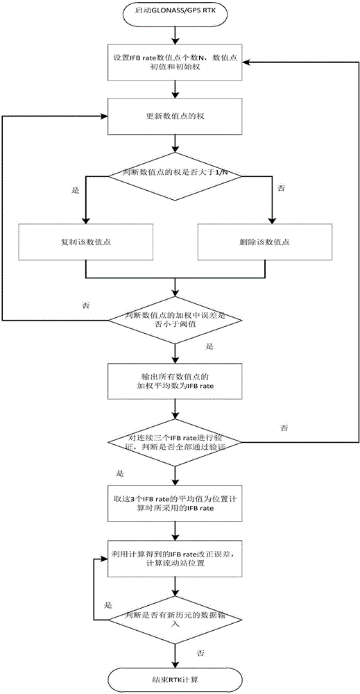
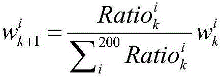
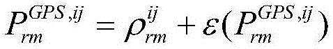
[0026] A GPS-assisted GLONASS single-frequency RTK positioning method provided by the present invention uses GLONASS+GPS observations to estimate the GLONASS IFB rate in real time, and uses the IFB rate to correct the inter-frequency deviation contained in the GLONASS observations, and then uses the LAMBDA algorithm to fix GLONASS+GPS The whole week ambiguity, and finally realize the RTK positioning operation based on GLONASS ambiguity fixation.

[0027] The general flowchart of the embodiment of the present invention is as follows figure 1 shown. Use ...


PUM


Abstract

The invention discloses a GPS based enhanced GLONASS RTK (Real-time Kinematic) positioning method, which is characterized in that a GLONASS+GPS RTK observation equation is built, and positioning is performed based on the observation equation. The GPS based enhanced GLONASS RTK positioning method comprises the steps of setting initial values and initial weights of N numerical points; updating the weight of each numerical point; judging whether the weight is greater than 1/N or not for each numerical point, if so, copying the numerical point, and if not, deleting the numerical point; judging whether an error in weighting all of the numerical points is less than a preset convergence threshold or not, and if so, enabling the weighted mean of all of the numerical points to act as an estimated IFB (Inter-frequency phase bias) rate; substituting a final IFB rate into the observation equation when a plurality of estimated IFB rates pass verification, performing GLONASS and GPS ambiguity fixing through an LAMBDA algorithm, and carrying out RTK positioning. According to the invention, GLONASS ambiguity fixing based GLONASS+GPS single-frequency RTK positioning is realized.

Description

technical field [0001] The invention belongs to the technical field of global navigation system and positioning measurement, and specifically relates to a method for calculating GLONASS inter-frequency bias (Inter-frequency phase bias, IFB) by using GLONASS+GPS phase and pseudorange observation values, thereby fixing GLONASS and GPS The whole week ambiguity, and then real-time dynamic positioning (Real-time KinematicPositioning) positioning technology to determine the precise position information of the rover. Background technique [0002] As the Russian GLONASS (GLONASS) satellite navigation system once again completed the full constellation operation of 24 satellites in 2012, the European GALILEO satellite navigation system accelerated the speed of networking, and my country's BeiDou Navigation Satellite System (BDS) began to conduct global satellite navigation. Range networking, traditional RTK (real-time dynamic differential positioning) positioning technology is developi...

Claims


Application Information

Patent Timeline
IPC IPC(8): G01S19/33G01S19/27
CPCG01S19/27G01S19/33
Inventor 姚宜斌许超钤胡明贤孔建
Owner WUHAN UNIV
Why Eureka
Try Eureka