
Multi-tide-level station sea way topographic survey tide level control method and water level self-recording meter fixing device

A topographic measurement and fixing device technology, which is applied in the direction of buoy liquid level indicators, etc., can solve the problems of difficulty, implementation difficulty, comprehensiveness of seaway topographic measurement at tide level stations, etc., and achieve the effect of ensuring correctness

Pending Publication Date: 2017-05-31
THREE GORGES HYDROLOGY & WATER RESOURCES SURVEY BUREAU
View PDF8 Cites 7 Cited by
  • Summary
  • Abstract
  • Description
  • Claims
  • Application Information

AI Technical Summary

Problems solved by technology

Although there are various processing methods for each technical requirement, the multi-tidal station seaway topographic survey is relatively comprehensive and difficult, which makes the implementation of this type of project difficult

Method used


Image

  • Multi-tide-level station sea way topographic survey tide level control method and water level self-recording meter fixing device
  • Multi-tide-level station sea way topographic survey tide level control method and water level self-recording meter fixing device
  • Multi-tide-level station sea way topographic survey tide level control method and water level self-recording meter fixing device

Examples


Embodiment Construction

[0042] Theoretical basis of tide level control method for seaway topographic survey at Honda tide level station:

[0043] (1) Least square fitting model

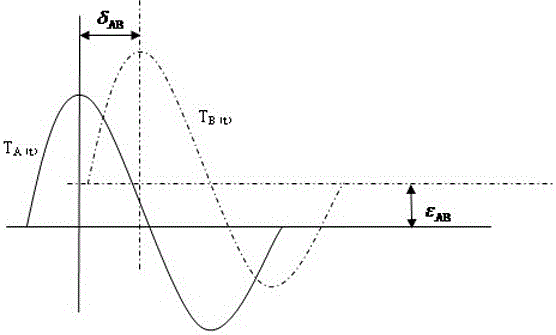
[0044] Such as figure 1 As shown, with time as the X-axis and tide level as the Y-axis, the curve T A (t) and T B (t) is the synchronous tide level curve of reference tide level station A and temporary tide level station B. There are three parameters differences between the two synchronous tide level curves, including the horizontal displacement, which is the tidal time difference δ between the two tide levels. AB ; The vertical displacement is the datum deviation ε of the two tide gauge stations AB (applied to this article is the initial zero point difference of the two tide gauge stations); and the ratio of the synchronous tide level value is the tidal range ratio γ AB . Then the curve T A (t) and T B (t) The following relationship exists:

[0045] T B (t) = γ AB ·T A (t+δ AB )+ε AB (1)

[0046] In the formu...


PUM


Abstract

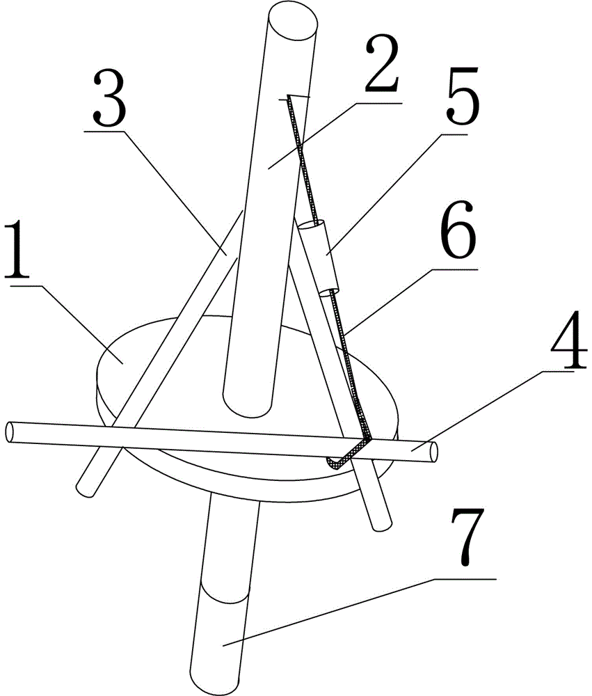
The invention discloses a multi-tide-level station sea way topographic survey tide level control method and a water level self-recording meter fixing device. The method comprises arrangement of a tide-level station, collection of tide-level data, null-point connection surveying of a sea area temporary tide-level station, and calculation and transfer of a basic ground; the fixing device comprises a fixing disc, a central rod is arranged at the central point of the fixing disc, one end of each of two reinforcing rods is connected to the central rod and the other end of each of the two reinforcing rods is connected to the edge of the fixing disc, the included angle of the two reinforcing rods is larger than 10 degrees, the two reinforcing rods are connected through a connecting rod, the joint of one reinforcing rod and the connecting rod is provided with a fixing rope sleeve, and one end of a fixing rope penetrates through the fixing rope sleeve and is connected to the other reinforcing rod; a water level self-recording meter is arranged on the central rod; balancers are arranged in the central rod and the reinforcing rods. The multi-tide-level station sea way topographic survey tide level control method and the water level self-recording meter fixing device have the advantages that the tide level can be precisely measured, thus a large area of sea area can be effectively controlled, and the purpose that the topographic survey of a large area of a multi-tide-level station sea way is achieved.

Description

technical field [0001] The invention relates to a tide level control method and device for multi-tidal level station seaway topographic measurement, in particular to a tide level control method for multi-tidal level seaway topographic measurement in a large area of ​​sea area. Background technique [0002] With the development and utilization of coastal and offshore areas, human activities such as ocean shipping, port wharf construction, and fish farming have become more frequent, and the requirements for ocean analysis and research have become higher and higher, which will inevitably lead to the requirement for detailed marine information. Higher and higher. The precision of large-area marine surveying and mapping has gradually realized the transition from small-scale surveying and mapping data to medium- and small-scale data. Therefore, the traditional surveying and mapping method of setting tide level stations along the coast and performing single-station tide level corr...

Claims


Application Information

Patent Timeline
Patent Type & Authority Applications(China)
IPC IPC(8): G01F23/30
CPCG01F23/30Y02A90/30
Inventor 李腾全小龙谭良李云中叶德旭柳长征黄童谭尧耕张黎明谭俊
Owner THREE GORGES HYDROLOGY & WATER RESOURCES SURVEY BUREAU
Learn More