
A real-time wide-area synchronous satellite monitoring method and monitoring system for mountain fires in power grids

A synchronous satellite and mountain fire technology, which is applied in radiation pyrometry, measuring devices, hot spot detection, etc. Reduced workload, real-time and wide-area improvements

Active Publication Date: 2017-12-26
STATE GRID HUNAN ELECTRIC POWER +3
View PDF4 Cites 0 Cited by
  • Summary
  • Abstract
  • Description
  • Claims
  • Application Information

AI Technical Summary

Problems solved by technology

One is to install mountain fire monitoring sensors on ground base stations or transmission line pole towers (see Chinese Patent No. ZL 201310290055.6) to monitor mountain fires within 3-5 kilometers around the base station in real time. Monitoring local areas cannot realize wide-area monitoring of wildfires in power grids, and cannot meet the monitoring needs of wildfires in power grids with multiple points and wide areas
The second is to use the infrared remote sensing data of polar-orbiting satellites such as aqua and terra to monitor the fire points near the transmission line. The main shortcoming is that the polar-orbiting satellites are affected by the transit time (only one polar-orbiting satellite transits every 1-2 hours on average) , and can only scan and cover 2000 kilometers each time, it is impossible to realize real-time and wide-area monitoring of wildfires (see Chinese patents such as ZL 201310421175.5)
[0004] In addition, the monitoring range of the geosynchronous satellite covers the whole of China, and the data is sent every 15 minutes, which can realize wide-area monitoring with high time accuracy, but the orbit of the geosynchronous satellite is 36,000 kilometers away from the ground, and the infrared signal is weak
Chinese patents such as ZL201310421175.5 use the threshold value of the infrared channel of polar-orbiting satellites for identification, which is suitable for polar-orbiting satellites with strong satellite signals, but not suitable for identifying fire points with weak infrared signals of synchronous satellites

Method used


Image

  • A real-time wide-area synchronous satellite monitoring method and monitoring system for mountain fires in power grids
  • A real-time wide-area synchronous satellite monitoring method and monitoring system for mountain fires in power grids
  • A real-time wide-area synchronous satellite monitoring method and monitoring system for mountain fires in power grids

Examples


Embodiment

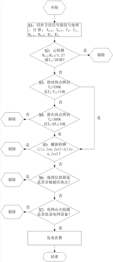
[0062] A real-time wide-area synchronous satellite monitoring system for wildfires in a power grid with a diameter of 7.3 meters for power transmission and transformation equipment, including:

[0063] Synchronous satellite signal receiving module: used to receive and process remote sensing signals of different wavelengths from synchronous satellites covering designated areas in real time;

[0064] Cloud detection module: used to detect the parameter value of each pixel point received by the synchronous satellite signal receiving module for cloud layer detection, and remove some pixels reflected from the cloud layer in the infrared satellite signal; the parameter value includes the reflection of each pixel point rate and / or brightness temperature values;

[0065] Absolute wildfire hotspot identification module: used to judge whether there are absolute wildfire hotspots in the synchronous satellite signal output by the cloud detection module;

[0066] Potential wildfire hotspo...


PUM


Abstract

A real-time wide-area synchronous satellite monitoring method for a mountain fire of the power grid comprises the following steps that a remote sensing signal receiver receives different wavelengths of remote sensing signals of a synchronous satellite which covers a specific area in real time; for each received pixel point, whether the pixel point belongs to a cloud layer is determined by carrying out cloud layer detection via a reflectivity and / or a brightness temperature of the pixel point; if the pixel point does not belong to a cloud layer, whether the pixel point is an absolute mountain fire hot spot is determined according to brightness temperature data of a specific channel; if the pixel point is not the absolute mountain fire hot spot, whether the pixel point is a potential mountain fire hot spot is determined according to brightness temperature data of pixel points in the surrounding; whether the determined absolute / potential mountain fire hot spot represents a solar flare is determined; if the determined absolute / potential mountain fire hot spot does not represent the solar flare, a digital map information map is used to obtain fire points by screening; and the fire points are determined by utilizing position information of power transmission and transformation equipment, and alarming is raised according to conditions. The method can be used to realize real-time and wide-area monitoring for the mountain fire of the power grid, and practical monitoring requirements for the mountain fire of the power grid are met.

Description

technical field [0001] The invention relates to the technical field of power grid wildfire monitoring, in particular to a method and system for real-time wide-area monitoring of power grid wildfires. Background technique [0002] In the central and eastern regions of my country, wildfire disasters are very prone to occur when the weather is continuous and fine. When it spreads to the vicinity of the power grid, it is easy to cause a large number of line trips and burnouts, which has become one of the most serious hazards to the safe operation of the power grid. Wildfires in power grids are highly random and widely distributed. Real-time wide-area monitoring is required to detect wildfires in time for early warning and disposal. [0003] There are mainly two methods for existing grid fire monitoring methods. One is to install mountain fire monitoring sensors on ground base stations or transmission line pole towers (see Chinese Patent No. ZL 201310290055.6) to monitor mountai...

Claims


Application Information

Patent Timeline
Patent Type & Authority Patents(China)
IPC IPC(8): G08B17/12G01J5/00
CPCG01J5/0014G01J5/0066G01J2005/0077G08B17/125
Inventor 陆佳政徐勋建刘毓李波方针
Owner STATE GRID HUNAN ELECTRIC POWER
Learn More