A method and system for generating latitude and longitude coordinates of railway lines

A technology of longitude and latitude and line, applied in the field of generating longitude and latitude coordinates of railway lines, can solve the problems of high work intensity, no automatic correlation method, automatic correlation between coordinates and kilometer markers, and high cost, so as to save labor costs and save the cost of measuring equipment. Effect

Active Publication Date: 2020-12-08
HUNAN CRRC TIMES SIGNAL & COMM CO LTD
View PDF6 Cites 0 Cited by
  • Summary
  • Abstract
  • Description
  • Claims
  • Application Information

AI Technical Summary

Problems solved by technology

[0003] At present, there are two main methods for generating the coordinates of railway lines. One is to use measuring equipment to manually measure and record along the railway lines by professionals. This method has the following disadvantages: first, the measurement workload is huge and requires a large number of professional surveyors; 2. Surveyors need to carry measuring equipment to measure along the line on foot, and the work intensity is very high;
This method solves the three shortcomings of the professional manual measurement method, but there are the following shortcomings: first, the measured coordinate information is not associated with the line kilometer mark, and a good automatic association method has not been found so far. Carry out automatic correlation between coordinates and mileage markers; second, it is necessary to purchase expensive professional measuring equipment, and require professionals to install and operate professional equipment on the vehicle for measurement, which is very expensive
[0005] In addition, these two methods also have a common problem of daily maintenance of line coordinate information. When a new line needs to be added to the line coordinate information, or when the line coordinate information needs to be updated due to the transformation of the existing line, the coordinates must be collected in time. Data, update line coordinate information

Method used


Image

  • A method and system for generating latitude and longitude coordinates of railway lines
  • A method and system for generating latitude and longitude coordinates of railway lines
  • A method and system for generating latitude and longitude coordinates of railway lines

Examples


no. 1 example

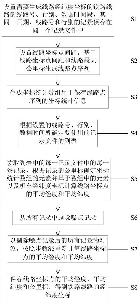
[0044] figure 1 The flowchart of an embodiment of the method for generating the latitude and longitude coordinates of a railway line in the present invention is shown. See figure 1 , the following is a detailed description of the implementation steps of the method of this embodiment.

[0045] Step S1: Set the line number, line number, and data time period of the railway line for which the latitude and longitude coordinates of the line need to be generated, wherein the records of the same date, line number, and line type are stored in the same record file.

[0046] Before this step, there is a process of data accumulation. The locomotive is generally equipped with a satellite positioning module and a LKJ device. Locomotive operation route information such as gender and kilometer mark, and send these two kinds of information to the ground LMD (LKJ Equipment Operation Monitoring and Management System) system.

[0047] Obtain record data such as locomotive latitude and longitude ...


PUM


Abstract

The invention discloses a method and a system for generating the latitude and longitude coordinates of a railway line, which automatically generates the latitude and longitude coordinates of a railway line by using statistical principles and big data technology. The technical solution is: set the line number, line type, and data time period of the railway line, and save the records of the same date, line number, and line type in the same record file; set the distance between line coordinate points, generate line point sequences; generate coordinate statistics Array; determine the list of record files to be used according to the set line number, row, and data time period; read each record in the list, determine the elements of the coordinate statistics array according to the kilometer mark, and calculate the average longitude and longitude of the line coordinate points Average latitude; remove noise records; take all records after removing noise records as objects, recalculate the average longitude and average latitude of the line coordinate points; save the average longitude, average latitude and kilometer mark of the line coordinate points, and obtain the longitude and latitude coordinates of the railway line .

Description

technical field [0001] The invention relates to the field of railway informatization in the railway industry, in particular to a method and system for generating longitude and latitude coordinates of railway lines. Background technique [0002] In a geographic information system (GIS, Geographic Information System), a map is composed of various primitives. According to the position and shape, the primitives are divided into three types: point primitives, line primitives and plane primitives. The point graphic element uses a latitude and longitude coordinate (hereinafter referred to as coordinate) to represent position information. A line primitive uses a sequence of coordinates to represent position information. The surface primitive uses a closed area surrounded by a sequence of coordinates connected end to end to represent position information. In GIS, a railway line is a line primitive, represented by a sequence of coordinates. In the field of railway geographic infor...

Claims


Application Information

Patent Timeline
Patent Type & Authority Patents(China)
IPC IPC(8): G06F16/29G06Q50/30
CPCG06Q50/30G06F16/29
Inventor 曾垂周吴俊亮周科松黄超邓国知胡嗣钦叶理辉
Owner HUNAN CRRC TIMES SIGNAL & COMM CO LTD
Why Eureka
Try Eureka