Method and system for iteratively updating high-fidelity land cover data

A technology of surface coverage and iterative update, applied in the field of geospatial information, can solve the problems of large additional data inspection and modification workload, reduce the production efficiency of surface coverage data update, and affect the quality of result data.

Active Publication Date: 2017-12-22
NAT GEOMATICS CENT OF CHINA
View PDF5 Cites 3 Cited by
  • Summary
  • Abstract
  • Description
  • Claims
  • Application Information

AI Technical Summary

Problems solved by technology

In the traditional update production of land cover data, because the surface cover change layer is collected independently, there is no strict geometric constraint relationship between the surface cover change map and the background map, and the same map usually collected is not completely When the changed layer and the background layer are merged and updated, serious topological errors such as map topological gaps, map topological overlaps, and illegal polygons will inevitably occur. Modification, resulting in a large amount of additional data inspection and modification workload, which reduces the work efficiency of surface cover data update production, and the topology error formed by the update is not completely modified and will be retained in the updated surface cover data, seriously affecting the quality of the result data

Method used


Image

  • Method and system for iteratively updating high-fidelity land cover data
  • Method and system for iteratively updating high-fidelity land cover data
  • Method and system for iteratively updating high-fidelity land cover data

Examples


Embodiment 1

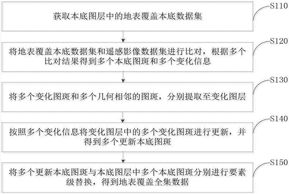
[0052] figure 1 It is a flow chart of the method for iteratively updating high-fidelity land cover data provided by Embodiment 1 of the present invention.

[0053] refer to figure 1 , the iterative update method for high-fidelity land cover data includes the following steps:

[0054] Step S110, obtaining the ground cover background data set in the background layer;

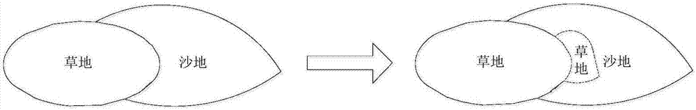
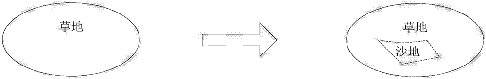
[0055] Step S120, compare the ground cover background data set with the remote sensing image data set, and obtain multiple background map spots and multiple change information according to multiple comparison results, the background map spots include change map spots and change map Spot geometrically adjacent spots;

[0056] Step S130, extracting a plurality of changed spots and a plurality of geometrically adjacent spots to the changed layer respectively;

[0057] Step S140, updating the multiple changed spots in the changed layer according to the multiple changed information, and obtaining multiple updated b...

Embodiment 2

[0090] Figure 4 It is a schematic structural diagram of the high-fidelity land cover data iterative update system provided by Embodiment 2 of the present invention.

[0091] refer to Figure 4 , the iterative update system for high-fidelity land cover data includes:

[0092] An acquisition unit 10, configured to acquire the ground cover background data set in the background layer;

[0093] The comparison unit 20 is used to compare the ground cover background data set and the remote sensing image data set, and obtain multiple background map spots and multiple change information according to multiple comparison results, the background map spots include change map spots and patches geometrically adjacent to the changing patch;

[0094] An extraction unit 30, configured to extract a plurality of changing spots and a plurality of geometrically adjacent spots to a changing layer;

[0095] An updating unit 40, configured to update a plurality of change spots in the change layer ...


PUM


Abstract

The invention provides a method and system for iteratively updating high-fidelity land cover data, and relates to the technical field of geographic space information. The method comprises the following steps of: obtaining a land cover background data set in a background layer; comparing the land cover background data set with a remote sensing image data set, and obtaining a plurality of background pattern spots and a plurality of pieces of change information according to a plurality of comparison results, wherein the background pattern spots comprise change pattern spots and pattern spots geometrically adjacent to the change pattern spots; respectively extracting a plurality of change pattern spots and a plurality of geometrically adjacent pattern spots to a change layer; updating the plurality of change pattern spots in the change layer according to the plurality of pieces of change information so as to obtain a plurality of updated background pattern spots; and respectively carrying out element-level replacement on the plurality of updated background pattern spots and the plurality of background pattern spots in the background layer so as to obtain land cover universal set data. According to the method and system, pattern spot profiles and topological structures of background data are strictly inherited, land cover updating operations are simplified, new topological problems are not generated, and quality levels of updated layers are ensured.

Description

technical field [0001] The invention relates to the technical field of geospatial information, in particular to a method and system for iteratively updating high-fidelity land cover data. Background technique [0002] Land cover data reflect the real state of land cover, which is of great significance for fine land supervision, agricultural and forestry planning, and ecological protection. Land cover data update is an important means to maintain the timeliness of land cover data. [0003] The correct spatial topology of land cover data is the primary factor to ensure the quality of land cover. In the traditional land cover data update production, because the surface cover change layer is collected independently, there is no strict geometric constraint relationship between the land cover change map and the background map, and the same map usually collected is not completely When the changed layer and the background layer are merged and updated, serious topological errors su...

Claims


Application Information

Patent Timeline
Patent Type & Authority Applications(China)
IPC IPC(8): G06F17/30G06T11/00
CPCG06F16/29G06T11/001
Inventor 高崟王发良贾云鹏程滔李广泳付文辉
Owner NAT GEOMATICS CENT OF CHINA
Why Eureka
Try Eureka