Land use combination form determination method related to road traffic accident risks

A technology of accident risk and road traffic, applied in data processing applications, instruments, calculations, etc., can solve problems such as lack, and achieve the effect of improving the accuracy of results

Inactive Publication Date: 2018-01-16
SOUTHEAST UNIV
View PDF2 Cites 8 Cited by
  • Summary
  • Abstract
  • Description
  • Claims
  • Application Information

AI Technical Summary

Problems solved by technology

In the past, the analysis of land use characteristics in road traffic risk analysis was only characterized by a single land use parameter, such as: the proportion of various types of land use in the region, the number of schools, etc., lacking a comprehensive reflection of land use scale, land use intensity, and land use type. Discrimination method of land use combination form with various characteristics such as land use mixing degree and so on

Method used


Image

  • Land use combination form determination method related to road traffic accident risks
  • Land use combination form determination method related to road traffic accident risks
  • Land use combination form determination method related to road traffic accident risks

Examples


Embodiment Construction

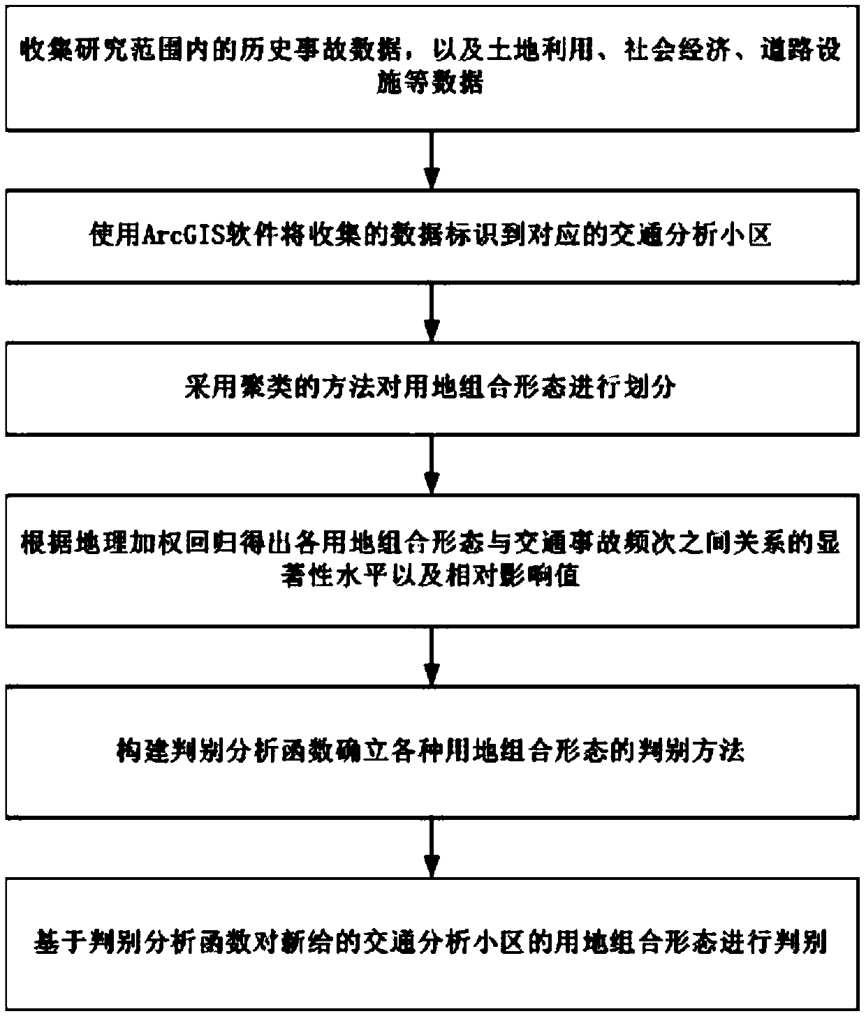
[0030] Below in conjunction with accompanying drawing and specific embodiment, further illustrate the present invention, should understand that following specific embodiment is only for illustrating the present invention and is not intended to limit the scope of the present invention, after having read the present invention, those skilled in the art will understand the present invention Modifications in various equivalent forms fall within the scope defined by the appended claims of the present application.

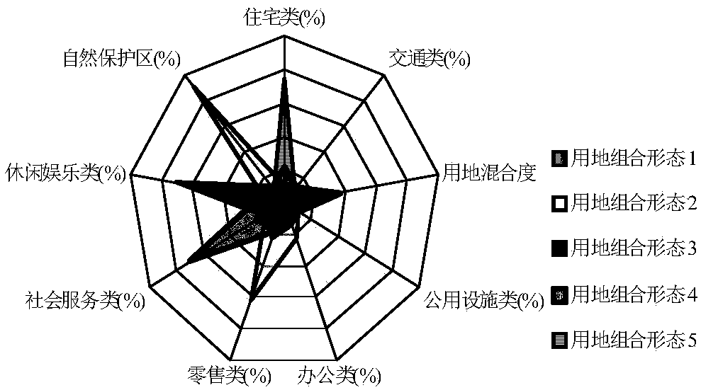
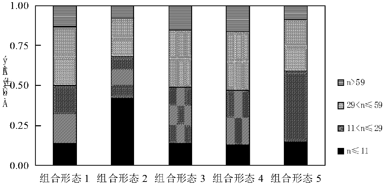
[0031] Such as figure 1 As shown, the embodiment of the present invention discloses a method for discriminating land-use combination forms related to the risk of road traffic accidents, including steps:

[0032] The first step is data collection, through data investigation and collection of historical accident data of the traffic analysis area within the research area, as well as four types of data, including land use, socio-economic, road facilities, and traffic operatio...


PUM


Abstract

The invention discloses a land use combination form determination method related to road traffic accident risks. The land use combination form determination method comprises steps of collecting history data and other parameters of each traffic analysis district in a research range, performing dividing on a land use combination form through a clustering method, establishing a geographic weighted regression model according to a partitioning result and extracting a risk land use form highly correlated to traffic accidents, constructing a determination analysis function, establishing determination methods for various land use combination forms, performing determination on a land use combination form of a newly-provided traffic analysis district on the basis of a determination analysis function, and determining risk land use characteristics. The land use combination form determination method related to road traffic accident risks overcome a past problem of lack of variety of land use characteristic representations and spatial heterogeneity, can accurately improve result accuracy and can provide a scientific and reasonable guidance to land planning and traffic safety prevention and control policy.

Description

technical field [0001] The present invention relates to a method for discriminating land use combination form related to road traffic accident risk. Specifically, the present invention comprehensively uses clustering, geographic weighted regression model and discriminant analysis method to propose a land use combination form discrimination method related to road traffic accident risk method, involving the fields of traffic safety and land planning. Background technique [0002] There is a complex interaction between land use and urban traffic. Land use and urban traffic are represented as a source-flow relationship on a macro level, and the road network is the carrier of the source-flow connection. Land is the carrier of urban social and economic activities. The spatial separation of various types of land use causes traffic flow, and the traffic flow between various land uses constitutes a complex urban traffic network. There is a relationship of mutual influence and inter...

Claims


Application Information

Patent Timeline
Patent Type & Authority Applications(China)
IPC IPC(8): G06Q50/26
Inventor 徐铖铖丁微刘攀
Owner SOUTHEAST UNIV
Why Eureka
Try Eureka