Lake basin ancient landform restoration-based quantitative method

A technology of paleotopography and stratigraphy, applied in geophysical surveys, instruments, etc., can solve the problems of heavy workload, lack of consideration of factors affecting paleo-water depth, large errors, etc., and achieve the effect of improving restoration accuracy and accurate and reliable restoration results.

Active Publication Date: 2018-05-04
CHINA NAT OFFSHORE OIL CORP +1
View PDF4 Cites 16 Cited by
  • Summary
  • Abstract
  • Description
  • Claims
  • Application Information

AI Technical Summary

Problems solved by technology

For example: layer leveling method is more intuitive and real, and easy to operate, but the error is relatively large; sedimentological analysis method needs to consider many factors, and the workload is huge; although the impression method is simple in principle, its accuracy is not good
Moreover, the above method does not take into account the important impact of the high-dip strata on the topographic restoration of the lake basin. In addition, it lacks consideration of the factors affecting the paleowater depth.

Method used


Image

  • Lake basin ancient landform restoration-based quantitative method
  • Lake basin ancient landform restoration-based quantitative method
  • Lake basin ancient landform restoration-based quantitative method

Examples


Embodiment Construction

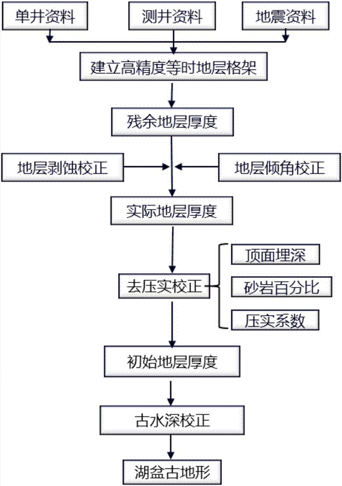
[0057] like figure 1 — Figure 5 Shown, the present invention adopts following steps:

[0058] Step 1: Establish a high-precision isochronous stratigraphic framework in the depression;

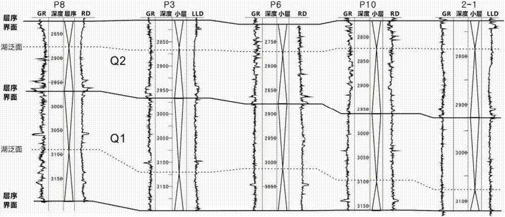
[0059] According to the theory of high-resolution sequence stratigraphy, a set of stable mudstone sections above the target layer is identified as the maximum flooding surface, the sequence boundary is determined, and a high-precision isochronous stratigraphic framework of the target layer is established, and the maximum lake flooding surface , to determine that the sequence boundary is divided into two complete third-order sequences Q1 and Q2;

[0060] The second step: select the marker layer, and determine the thickness of the residual strata in the second member of the sag area;

[0061] Select the nearest and most stable Q1 flooding surface as the marker layer, and interpret the bottom surface of the second member of the sag area and the layer corresponding to the largest lake flooding ...


PUM


Abstract

The invention provides a lake basin ancient landform restoration-based quantitative method. The method comprises the following steps of 1, establishing a high-precision isochronal stratigraphic framework in a recessed area; 2, selecting a marker bed, and determining the thickness of a two-section residual stratum in the recessed area; 3, adopting the mudstone sound wave time-difference method, andcorrecting the residual stratum thickness of a target layer to be the actual stratum thickness; 4, carrying out stratum inclination angle correction; 5, subjecting the actual formation thickness of arecovery layer to de-compaction treatment so as to determine the initial deposition time thickness; 6, restoring ancient water depth values at a plurality of well points through rock core analysis and thickness measurement, and converting the thickness of the stratum into the distribution of the paleo-water-depth according to the thickness correspondence relation between the paleo-water-depth andthe thickness of the initial sedimentary period, namely quantitatively restoring the lake basin shape. According to the invention, not only the influence problem of stratum dip angle, stratum erosionand stratum compaction effect on the thickness is solved, but also the lake basin shape can be quantitatively represented. The distribution of the paleo-water-depth is quantified. The precision problem when the lake basin shape is recovered is solved. The recovery precision of the lake basin shape is improved.

Description

technical field [0001] The invention relates to lake basin paleotopography, in particular to a quantitative method based on lake basin paleotopography restoration. The invention belongs to the technical field of oil and gas field exploration and development. Background technique [0002] The related research on lake basin topography restoration originated in the 1950s, and after more than 60 years of development, this research has been widely used in many disciplines. In geological research, the restoration of lake basin topography plays a particularly important role, providing important guidance and reference for the genesis, development model and distribution of different sedimentary types of reservoirs. In addition, it also plays a pivotal role in the study of paleontology, paleogeography, and paleostructure. However, at present, there are many problems in the restoration methods of lake basin topography, most of which remain at the qualitative stage. Therefore, quantit...

Claims


Application Information

Patent Timeline
Patent Type & Authority Applications(China)
IPC IPC(8): G01V9/00
CPCG01V9/00
Inventor 田立新张建民苏彦春张岚崔龙涛王少鹏李超郭诚江远鹏穆朋飞
Owner CHINA NAT OFFSHORE OIL CORP
Why Eureka
Try Eureka