Urban slope geologic disaster risk evaluation visual display method

A geological disaster and risk technology, applied in the visual display of urban slope geological disaster risk assessment and the field of geological disaster assessment, can solve the problems of inconvenient popularization and application, and it is difficult for ordinary residents to understand the product content, so as to achieve strong spatial display effect and improve The effect of active disaster prevention awareness, reducing casualties and property losses

Inactive Publication Date: 2018-06-12
INST OF EXPLORATION TECH OF CHINESE ACAD OF GEOLOGICAL SCI
View PDF4 Cites 10 Cited by
  • Summary
  • Abstract
  • Description
  • Claims
  • Application Information

AI Technical Summary

Problems solved by technology

[0003] Most of the geological disaster risk assessment products in the existing technology are based on ARCGIS maps. These products are developed on the basis of DEM and require a certain professional foundation to understand. Ordinary residents in the research area often find it difficult to understand the content expressed by the products. , it is not convenient to promote the application

Method used


Image

  • Urban slope geologic disaster risk evaluation visual display method
  • Urban slope geologic disaster risk evaluation visual display method
  • Urban slope geologic disaster risk evaluation visual display method

Examples


Embodiment Construction

[0026] The specific embodiment of the present invention will be further described in detail below in conjunction with the accompanying drawings.

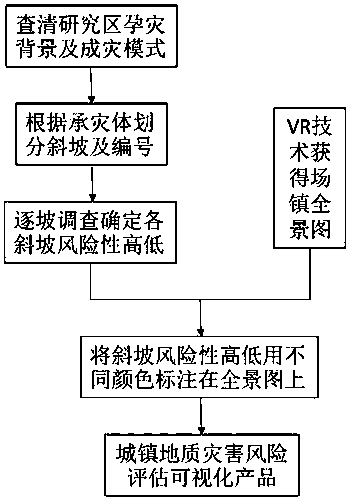
[0027] The method for visually displaying the risk assessment of urban slope geological hazards according to the present invention comprises the following steps:

[0028] step 1. In the target area, all slopes that may cause geological disasters are selected, and the geological disasters are serious damages caused by geological movements to the affected objects;

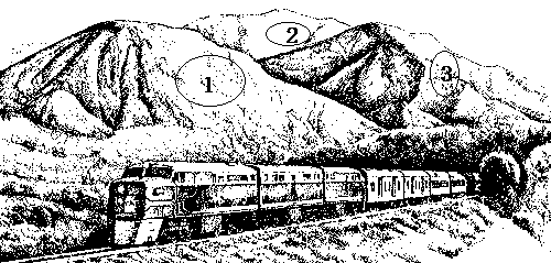
[0029] Since geological disasters are the result of serious impact of geological action on disaster-affected objects, no disaster-affected object, no matter how dangerous the slope is, does not constitute a disaster. Therefore, the geological disaster risk assessment visualization product should divide and number the slopes with disaster-affected objects, for example The disaster-affected objects are usually man-made projects such as buildings, roads, reservoirs, artifici...


PUM


Abstract

An urban slope geologic disaster risk evaluation visual display method includes following steps: step 1, picking out all slopes probably causing geologic disasters in a target area, wherein the geologic disasters refer to serious damage caused to disaster-stricken objects by geologic motion; step 2, evaluating slope danger grade of each slope, and evaluating grade of damage caused to disaster-stricken objects probably existing around each slope when the slope is in geologic motion; step 3, determining risk grade in a danger and damage matrix according to the sum of the danger grade and the damage grade which are acquired by evaluation; step 4, marking and showing each slope with the risk grade determined on a geologic information map. Through a carrier of a geologic disaster risk evaluation visual product, risk of slopes in front and rear of own houses can be known clearly and visually; multiple risk factors are taken into consideration for comprehensive evaluation, so that risk and possible damage of landslide within jurisdiction are known comprehensively and accurately.

Description

technical field [0001] The invention belongs to the field of geology, and relates to a method for assessing geological disasters, in particular to a method for visually displaying the risk assessment of urban slope geological disasters. Background technique [0002] China is a mountainous country, especially in the western and southeastern mountainous areas. Geological disasters on slopes such as landslides, mudslides, slides, slides, collapses, and weathering fall off often occur. There are common natural disasters in the vicinity. The occurrence of disasters has the characteristics of many points, wide areas, and long lines. With limited manpower, material resources, and financial resources, protection and management are very difficult and even impossible to prevent. It has become the primary factor threatening the settlements in Linpo. [0003] Most of the geological disaster risk assessment products in the existing technology are based on ARCGIS maps. These products are ...

Claims


Application Information

Patent Timeline
Patent Type & Authority Applications(China)
IPC IPC(8): G06Q10/06G06F17/30G06T17/00
CPCG06Q10/0635G06T17/00G06F16/29
Inventor 易靖松张勇苗朝蔡佳军程英建
Owner INST OF EXPLORATION TECH OF CHINESE ACAD OF GEOLOGICAL SCI
Why Eureka
Try Eureka