Method for flood two-dimensional and three-dimensional dynamic display by using river channel actually measured water level

A three-dimensional dynamic and water level technology, applied in special data processing applications, image data processing, structured data retrieval, etc., can solve the problems of not being able to match the map, being dazzled, and being unable to understand the flood dynamics as a whole, so as to achieve a realistic display effect and promote The effect of development

Active Publication Date: 2018-06-22
河南省水利勘测设计研究有限公司
View PDF11 Cites 11 Cited by
  • Summary
  • Abstract
  • Description
  • Claims
  • Application Information

AI Technical Summary

Problems solved by technology

However, in the display of river water level data, it is often displayed through simple tables, curves, or vertical and horizontal profiles. On the one hand, this display method cannot match maps and aerial images to visually display information such as the evolution process of floods and the location of flood peaks. On the one hand, when there are many monitoring sections and a large amount of monitoring data, it will be dazzling to display the water level process of multiple sections at the same time, and it is impossible to understand the flood dynamics as a whole

Method used


Image

  • Method for flood two-dimensional and three-dimensional dynamic display by using river channel actually measured water level
  • Method for flood two-dimensional and three-dimensional dynamic display by using river channel actually measured water level
  • Method for flood two-dimensional and three-dimensional dynamic display by using river channel actually measured water level

Examples


Embodiment Construction

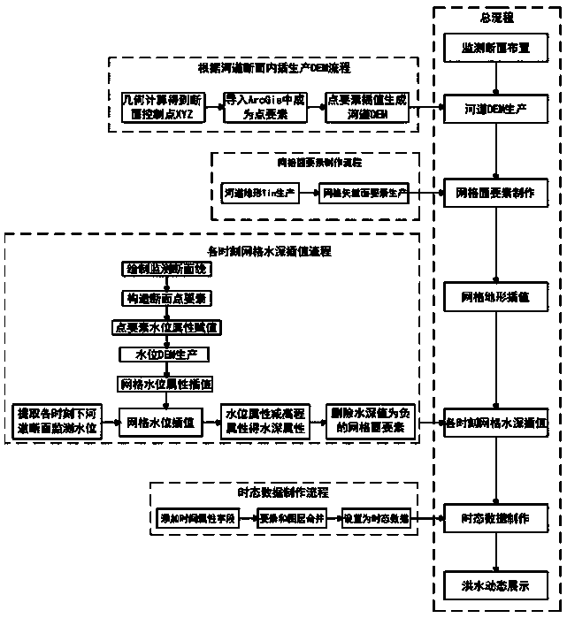
[0052] The embodiments of the present invention will be described in detail below with reference to the accompanying drawings. This embodiment is implemented on the premise of the technical solution of the present invention, and provides detailed implementation modes and specific operation processes, but the protection scope of the present invention is not limited to the following described embodiment.

[0053] The method of the present invention for using the measured water level of a river to perform two-dimensional and three-dimensional dynamic display of floods is now taking the dynamic display of floods in a river as an example. Specific steps are as follows:

[0054] Step 1. Monitoring section layout:

[0055] The more water level monitoring sections of the river are arranged and the larger the amount of data, the higher the accuracy of flood dynamic display and the better the effect. Therefore, if the cost allows, as many water level monitoring sections as possible sho...


PUM


Abstract

The invention discloses a method for flood two-dimensional and three-dimensional dynamic display by using a river channel actually measured water level. A data processing tool provided by an ageographic information platform ArcGis is used, and the method comprises the following steps of 1, cross section arrangement monitoring; 2, river DEM production; 3, grid surface element manufacturing; 4, gridterrain interpolation; 5, grid water depth interpolation at each moment; 6, temporal data manufacturing; 7, flood dynamic display. According to the method, a traditional river channel water level display mode is completely changed, combined display of water level data can be achieved, and after the flood data is superimposed on a topographic map, an aerial image and a DEM, the display effect is more vivid and is like real flood flowing on a river channel; conditions, such as the water surface width change, water depth distribution and the flood peak position, are clear at a glance in the display process, so that decision-making departments are assisted in mastering the overall dynamic conditions of flood more visually, and the development purpose of the water conservancy informatization technology is achieved.

Description

technical field [0001] The invention relates to the application of GIS technology and water conservancy information technology in river flood control, in particular to a method for using the measured water level of the river channel to perform two-dimensional and three-dimensional dynamic display of floods. Background technique [0002] At present, the water conservancy information system developed based on the river water level monitoring data plays an important role in river flood control and auxiliary decision-making. However, in the display of river water level data, it is often displayed through simple tables, curves or vertical and horizontal sections. On the one hand, this display method cannot match the map and aerial imagery to visually display the flood evolution process, flood peak location and other information, on the other hand On the one hand, when there are many monitoring sections and a large amount of monitoring data, it will be dazzling to display the wate...

Claims


Application Information

Patent Timeline
Patent Type & Authority Applications(China)
IPC IPC(8): G06F17/30G06T17/05
CPCG06T17/05G06F16/29Y02A10/40
Inventor 屈志刚朱太山陈功军白勇张玉明张金辉马山玉李政鹏王新平侯燕方祥宇胡晓峰赵蓓蓓张波李柄邑
Owner 河南省水利勘测设计研究有限公司
Why Eureka
Try Eureka