
Intelligent navigation method based on Internet

An intelligent navigation and Internet technology, which is applied in the field of Internet-based intelligent navigation, can solve the problems that vehicles without navigation cannot be processed, the timeliness of information update is insufficient, and road changes cannot be reflected in real time.

Inactive Publication Date: 2018-07-17
东莞市精联精密技术有限公司
View PDF4 Cites 2 Cited by
  • Summary
  • Abstract
  • Description
  • Claims
  • Application Information

AI Technical Summary

Problems solved by technology

[0004] 1. The traditional navigation system is based on maps and GPS to complete vehicle positioning and formulate routes, which cannot reflect road changes in real time;
[0005] 2. The information collection of road traffic flow by traditional navigation is based on the GPS position and speed feedback of the navigation system system. It can only collect the information of the vehicle-mounted host computer that uses the same type of navigation, and cannot process it for vehicles without navigation;
[0006] 3. The map update of the traditional navigation system relies on satellites and municipal planning maps, and the timeliness of information update is insufficient

Method used


Image

  • Intelligent navigation method based on Internet

Examples


Embodiment

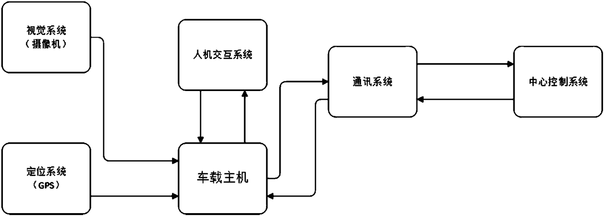
[0020] see figure 1 , the present invention provides a technical solution: an intelligent navigation method based on the Internet, including a central control system, a communication system, a vehicle host, a human-computer interaction system, a vision system and a positioning system, the human-computer interaction system, vision system and The positioning system is installed on the vehicle host, and the intelligent navigation method comprises the following steps:

[0021] Step 1: The vision system collects and recognizes road and traffic flow information in real time, as well as information such as congestion, road conditions, road surface conditions, traffic accidents, and traffic signals, and sends them to the central control system regularly. The unknown road information identified by the vision system is updated by the control center. ;

[0022] Step 2: The positioning system regularly updates the location information of the vehicle-mounted host to the central control sy...


PUM


Abstract

The invention relates to the technical field of motor vehicle navigation, and discloses an intelligent navigation method based on the Internet. A central control system, a communication system, a vehicle-mounted host, a human-computer interaction system, a vision system and a positioning system are involved, the human-computer interaction system, the vision system and the positioning system are installed on the vehicle-mounted host, the vehicle-mounted host, the human-computer interaction system, the vision system and the positioning system are connected with the central control system throughthe communication system, and the communication system is a wireless mobile communication system. By means of the method, the optimum driving route can be determined according to the position of thevehicle-mounted host, real-time map condition updating, real-time traffic information and traffic light condition, recognition of unknown streets can be achieved to update and complete a map.

Description

technical field [0001] The invention relates to the technical field of motor vehicle navigation, in particular to an Internet-based intelligent navigation method. Background technique [0002] The number of motor vehicles in modern society continues to increase, the frequency of people's travel is also increasing, and the road environment is becoming more and more complex, resulting in higher requirements for navigation systems. [0003] Traditional navigation has the following problems in use: [0004] 1. The traditional navigation system is based on maps and GPS to complete vehicle positioning and formulate routes, which cannot reflect road changes in real time; [0005] 2. The information collection of road traffic flow by traditional navigation is based on the GPS position and speed feedback of the navigation system system. It can only collect the information of the vehicle-mounted host computer that uses the same type of navigation, and cannot process it for vehicles w...

Claims


Application Information

Patent Timeline
Patent Type & Authority Applications(China)
IPC IPC(8): G01C21/34
CPCG01C21/3415
Inventor 王锐谢运才
Owner 东莞市精联精密技术有限公司
Learn More