Sub-pixel positioning method and system based on spatial gravity and pixel aggregation

A positioning method and sub-pixel technology, applied in the field of remote sensing, can solve the problems of neglecting spatial correlation, inability to obtain, high sub-pixel positioning accuracy, etc., to break through the limitation of spatial resolution, improve sub-pixel positioning accuracy, The effect of high spatial correlation

Active Publication Date: 2020-08-11
INST OF AGRI RESOURCES & REGIONAL PLANNING CHINESE ACADEMY OF AGRI SCI
View PDF5 Cites 0 Cited by
  • Summary
  • Abstract
  • Description
  • Claims
  • Application Information

AI Technical Summary

Problems solved by technology

[0004] However, most of the above sub-pixel localization models can only target one of the two sizes of ground objects, and few models can take into account the coexistence of both
For example, the sub-pixel positioning model based on spatial correlation is mainly aimed at the situation where the object size is larger than the pixel resolution. Plaques are easily overlooked, which affects the sub-pixel positioning effect and mapping quality
The sub-pixel localization model based on spatial pattern fitting is mainly aimed at the situation where the size of ground objects is smaller than the pixel resolution, and relies too much on the training image structure information, while ignoring the spatial correlation between experimental image pixels / sub-pixels, thus Unable to obtain high sub-pixel positioning accuracy

Method used


Image

  • Sub-pixel positioning method and system based on spatial gravity and pixel aggregation
  • Sub-pixel positioning method and system based on spatial gravity and pixel aggregation
  • Sub-pixel positioning method and system based on spatial gravity and pixel aggregation

Examples


Embodiment Construction

[0028] Embodiments of the present invention are described below with reference to the drawings, in which like parts are denoted by like reference numerals. In the case of no conflict, the following embodiments and the technical features in the embodiments can be combined with each other.

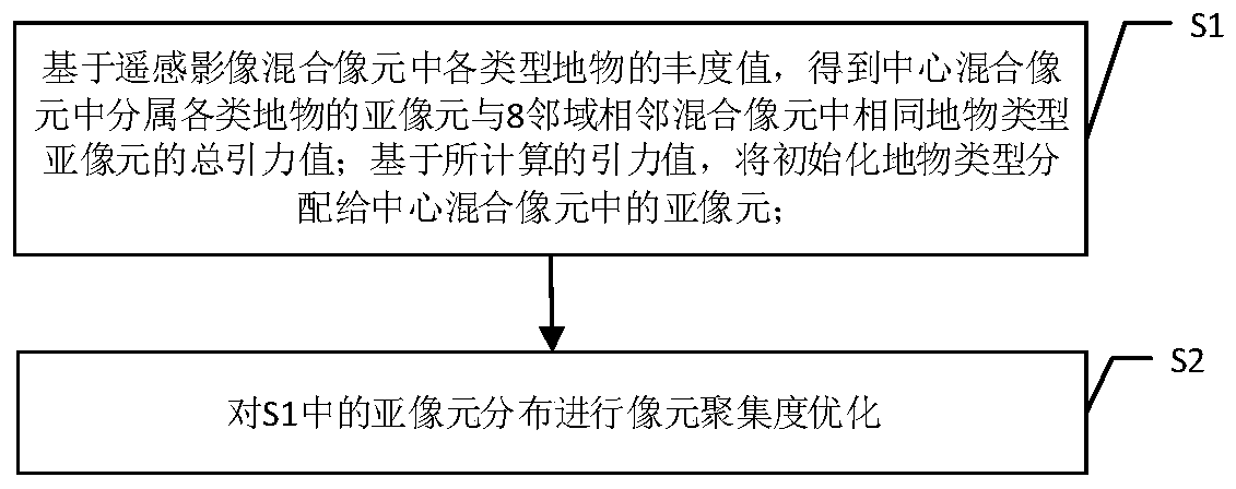
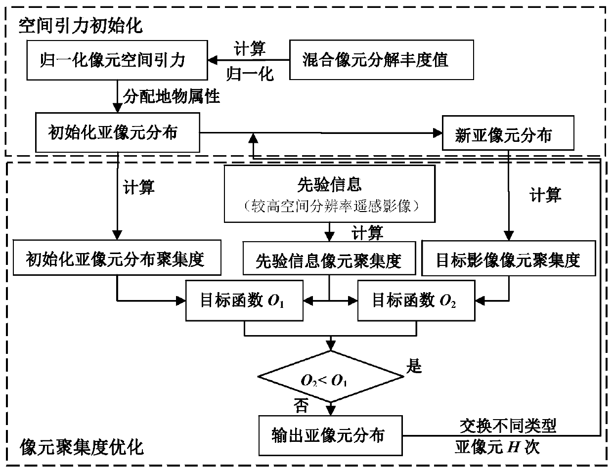
[0029] The method of the invention includes two parts: space gravity initialization and pixel aggregation degree optimization. The principle diagram of the method of the present invention is as Figure 1-2 shown.

[0030] Step S1, based on the abundance values ​​of various types of ground objects in the mixed pixel of the remote sensing image, the sub-pixels belonging to various types of ground objects in the central mixed pixel and the sub-pixels of the same type of ground objects in the 8 adjacent mixed pixels are obtained. The total gravitational value of the pixel is normalized to calculate the normalized gravitational value of each type of surface object in the remote sensing image in...


PUM


Abstract

The present invention provides a sub-pixel positioning method and system based on spatial gravity and pixel aggregation, the method includes: S1, based on the abundance values ​​of various types of ground objects in the remote sensing image mixed pixel, to obtain the central mixed pixel The total gravitational value of the sub-pixels belonging to various types of ground features and the sub-pixels of the same ground feature type in the 8 adjacent mixed pixels; based on the calculated gravitational value, assign the initialized ground feature type to the central mixed image sub-pixels in the unit; S2, optimize the pixel aggregation degree for the distribution of sub-pixels in S1, including: S21, calculate the objective function of the pixel aggregation degree; S22, exchange pixels to optimize the spatial distribution of sub-pixels and update The objective function in S21; S23, traversing all mixed pixels in the remote sensing image, and executing step S22 for each mixed pixel; S24, using an iterative algorithm, repeating steps S22-step S23. The sub-pixel positioning results calculated by the method and system of the present invention not only have high spatial correlation, but also have effective spatial distribution of ground objects, which improves the applicability of the sub-pixel positioning model for different sizes of ground objects.

Description

technical field [0001] The present invention relates to remote sensing technology, and more specifically, to a sub-pixel positioning method. Background technique [0002] The common phenomenon of mixed pixels in remote sensing images has become one of the main obstacles to further improve the accuracy of object recognition and remote sensing classification. For the decomposition of mixed pixels, it is necessary to study the properties, abundance and spatial distribution of the pixels in the mixed pixels. The corresponding technologies are endmember extraction technology, mixed pixel decomposition technology and sub-pixel positioning technology. Judging from the existing research, there are many and in-depth studies on the first two technologies. However, only relying on endmember extraction technology and mixed pixel decomposition technology can only obtain the proportion information of each endmember in the mixed pixel, but cannot obtain the distribution of various ground ...

Claims


Application Information

Patent Timeline
Patent Type & Authority Patents(China)
IPC IPC(8): G06K9/00
CPCG06V20/194G06V20/188G06V20/13
Inventor 吴尚蓉陈仲新刘杏认任建强
Owner INST OF AGRI RESOURCES & REGIONAL PLANNING CHINESE ACADEMY OF AGRI SCI
Why Eureka
Try Eureka