A method for updating multi-scale map data

A map data and update method technology, applied in database update, structured data retrieval, electronic digital data processing and other directions, can solve the problems of small matching range of elements, unpredictable changing elements, and low matching efficiency of map element update and so on.

Active Publication Date: 2019-01-04
GUANGZHOU URBAN PLANNING & DESIGN SURVEY RES INST
View PDF5 Cites 20 Cited by
  • Summary
  • Abstract
  • Description
  • Claims
  • Application Information

AI Technical Summary

Problems solved by technology

[0008] The embodiment of the present invention provides a method for updating multi-scale map data, which can effectively solve the problems that the existing technology cannot predict changing elements, the matching range of elements is small, and the matching efficiency is low when map elements are updated.

Method used


Image

  • A method for updating multi-scale map data
  • A method for updating multi-scale map data
  • A method for updating multi-scale map data

Examples


Embodiment Construction

[0101] The following will clearly and completely describe the technical solutions in the embodiments of the present invention with reference to the accompanying drawings in the embodiments of the present invention. Obviously, the described embodiments are only some, not all, embodiments of the present invention. Based on the embodiments of the present invention, all other embodiments obtained by persons of ordinary skill in the art without creative efforts fall within the protection scope of the present invention.

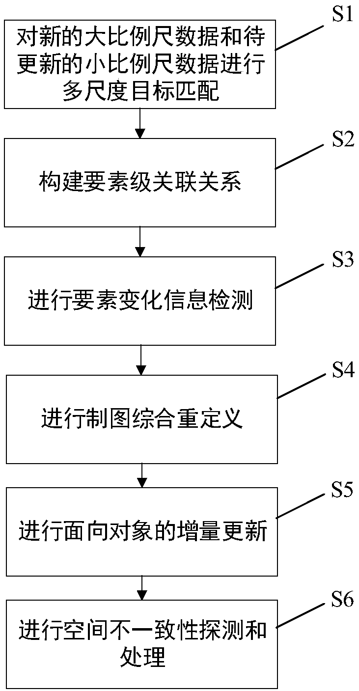
[0102] see figure 1 , is a schematic flowchart of a method for updating multi-scale map data provided by an embodiment of the present invention, and the specific update steps are as follows:

[0103] S1. Perform multi-scale target matching on the new large-scale data and the small-scale data to be updated;

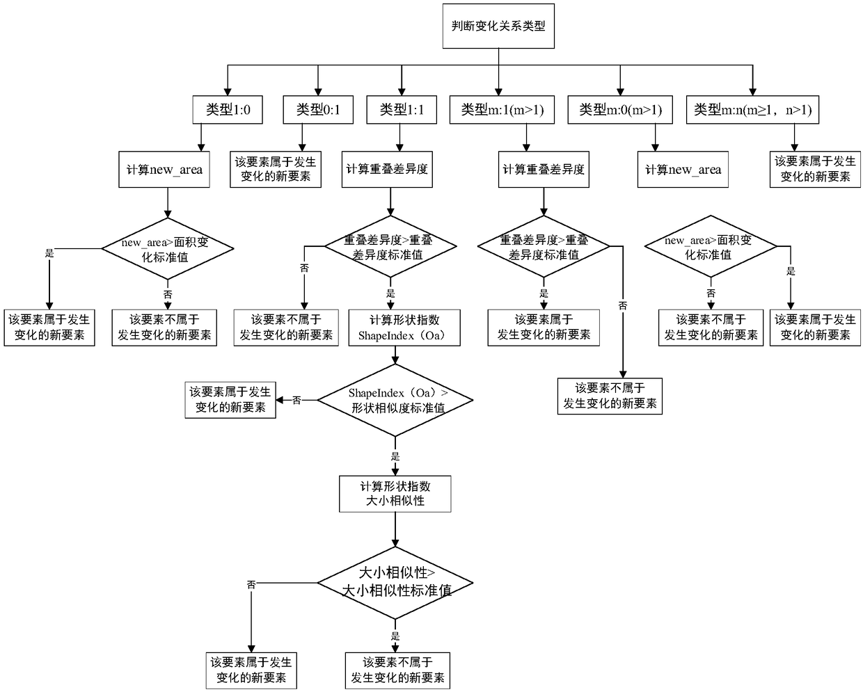
[0104] Among them, when the matching target is a point-like entity, semantic similarity and Euclidean distance similarity are used for matching: proper nouns ...


PUM


Abstract

The invention discloses a multi-scale map data updating method, which comprises the following steps: matching the new large-scale data and the small-scale data to be updated with multi-scale targets;constructing element-level relationship; conducting element change information detection; cartographic generalization and redefinition; object-oriented incremental updating; spatial inconsistency detection and processing. The multi-scale map data updating method disclosed by the invention can effectively solve the problems that the prior art is unable to accurately identify the change informationand predict the transmission scale of the change element updating, the matching range of the element is small, and the efficiency of the map element updating is low.

Description

technical field [0001] The invention relates to the technical field of multi-scale map updating, in particular to a method for updating multi-scale map data. Background technique [0002] Reliable, applicable and timely geospatial data is of great significance for major national strategic projects such as geographic national conditions monitoring, land space optimization, ecological red line protection, and smart city construction. The current status of basic geographic data is one of the important signs to measure its application value, which directly restricts its use value and scope of use. At present, all cities above the prefecture level and more than 400 county-level cities in the country have launched the construction of digital cities, and the construction of digital cities above the prefecture level has been fully completed. The focus of basic surveying and mapping work has shifted from data production to data maintenance, especially the current update and consiste...

Claims


Application Information

Patent Timeline
Patent Type & Authority Applications(China)
IPC IPC(8): G06F16/909G06F16/23G06F17/27G06N3/04
CPCG06F40/289G06F40/30G06N3/045
Inventor 陈利燕何华贵林鸿肖炜枝张鹏程陈飞张百灵
Owner GUANGZHOU URBAN PLANNING & DESIGN SURVEY RES INST
Why Eureka
Try Eureka