Mining area distribution thematic information extraction method based on multi-source remote sensing images

A remote sensing image and thematic information technology, applied in the field of remote sensing image processing, can solve the problems of low material work efficiency, a large amount of manpower, and expensive aerial photos

Inactive Publication Date: 2019-02-22
STATE GRID ECONOMIC TECH RES INST CO +2
View PDF6 Cites 3 Cited by
  • Summary
  • Abstract
  • Description
  • Claims
  • Application Information

AI Technical Summary

Problems solved by technology

In mining area deformation monitoring based on DInSAR technology, GeL, Chang HC, Janssen V, Rizos C. Integration of GPS, radar interferometry and GIS for ground deformation monitoring. GPS Solutions, 2003, 7 (1): 52-54 disclosed a The closest solution is to directly use differential interfero

Method used


Image

  • Mining area distribution thematic information extraction method based on multi-source remote sensing images
  • Mining area distribution thematic information extraction method based on multi-source remote sensing images
  • Mining area distribution thematic information extraction method based on multi-source remote sensing images

Examples


Embodiment Construction

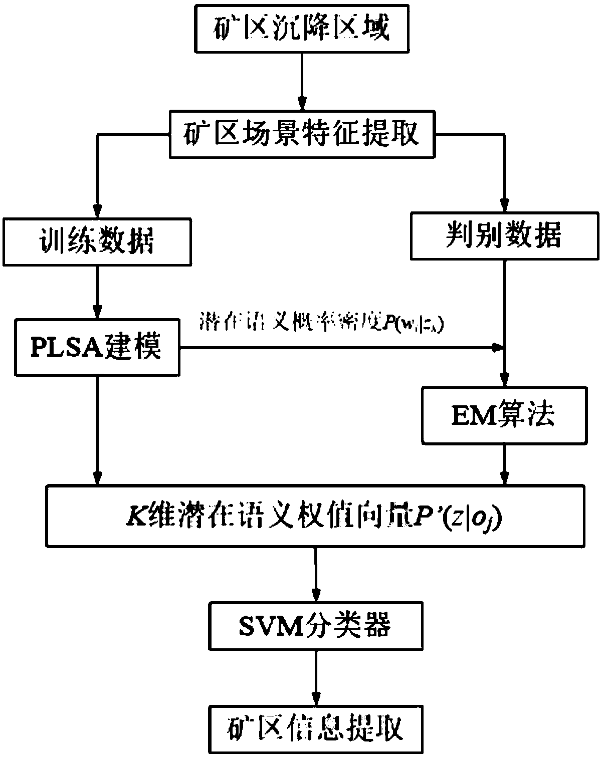
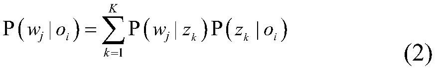
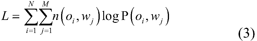
[0040] The characteristics and exemplary embodiments of various aspects of the present invention will be described in detail below. In order to make the purpose, technical solutions and advantages of the present invention more clear, the present invention will be further described in detail below in conjunction with the accompanying drawings and embodiments. It should be understood that the specific embodiments described here are only configured to explain the present invention, not to limit the present invention. It will be apparent to one skilled in the art that the present invention may be practiced without some of these specific details. The following description of the embodiments is only to provide a better understanding of the present invention by showing examples of the present invention.

[0041] It should be noted that in this article, relational terms such as first and second are only used to distinguish one entity or operation from another entity or operation, and ...


PUM


Abstract

The invention provides a mining area distribution thematic information extraction method based on multi-source remote sensing images, comprising extracting land subsidence information, calculating uplift information characteristics of target area according to radiant value of remote sensing image interferogram of target area, dividing possible mining area according to sudden change characteristicsof uplift, and further identifying combined with radar image, extracting land subsidence information; establishing a thematic semantic model of mining area, and adopting the probabilistic latent semantic analysis method to model the latent semantics, and the scene of mining area is expressed by the feature vector of latent semantics; extracting information from multi-source remote sensing imagesof mining area. The invention not only greatly reduces the cost, but also is convenient to operate and greatly improves the working efficiency by using the mode of combining the multi-source optical images and the radar images. For the influence of vegetation, the vegetation index is used to extract the thematic information from the non-vegetation-covered area.

Description

technical field [0001] The invention relates to the technical field of remote sensing image processing, in particular to a method for extracting thematic information of mining area distribution based on multi-source remote sensing images. Background technique [0002] Remote sensing monitoring of mining areas is an important national economic investigation work, one of the important means for mining administration departments to grasp the development status of mineral resources and the geological environment of mining areas, and an important task of land and resources investigation. Therefore, a variety of methods are used in various fields to extract mining areas. In the field of remote sensing, radar images or optical images are used for information extraction, and remarkable results have been achieved. [0003] Thematic information extraction of remote sensing mining areas used to be mainly visual interpretation, identifying mining areas on remote sensing images, suppleme...

Claims


Application Information

Patent Timeline
IPC IPC(8): G06K9/00G06K9/40G06K9/62
CPCG06V20/13G06V10/30G06F18/2411
Inventor 韩文军刘海波张济勇孙小虎张苏刘首文穆伟光张亚平于高陈颖蒲洁赵雨戴艳姚春静
Owner STATE GRID ECONOMIC TECH RES INST CO
Why Eureka
Try Eureka