motorized station automatic target detection and spatial positioning method based on YOLO-SIOCTL

A technology of target detection and space positioning, which is applied to satellite radio beacon positioning systems, measuring devices, computer components, etc., and can solve problems such as low inspection efficiency

Active Publication Date: 2019-06-11
NANJING GUOTU INFORMATION IND
View PDF4 Cites 7 Cited by
  • Summary
  • Abstract
  • Description
  • Claims
  • Application Information

AI Technical Summary

Problems solved by technology

[0002] During inspection and supervision, manual target viewing is usually required, and the inspection efficiency is low. The Vehicle-Borne Mobile Mapping Systems uses the car as a remote sensing platform and installs a high-precision dynamic Global Navigation Satellite System (GNSS ) and high dynamic carrier attitude sensor (Inertial Measurement Unit, IMU), based on GNSS / IMU combined positioning and attitude sensor, the vehicle system has the ability of direct geolocation (Direct Georeferencing, DG)

Method used


Image

  • motorized station automatic target detection and spatial positioning method based on YOLO-SIOCTL
  • motorized station automatic target detection and spatial positioning method based on YOLO-SIOCTL
  • motorized station automatic target detection and spatial positioning method based on YOLO-SIOCTL

Examples


Embodiment Construction

[0057] Embodiments of the present invention will be described in further detail below in conjunction with the accompanying drawings.

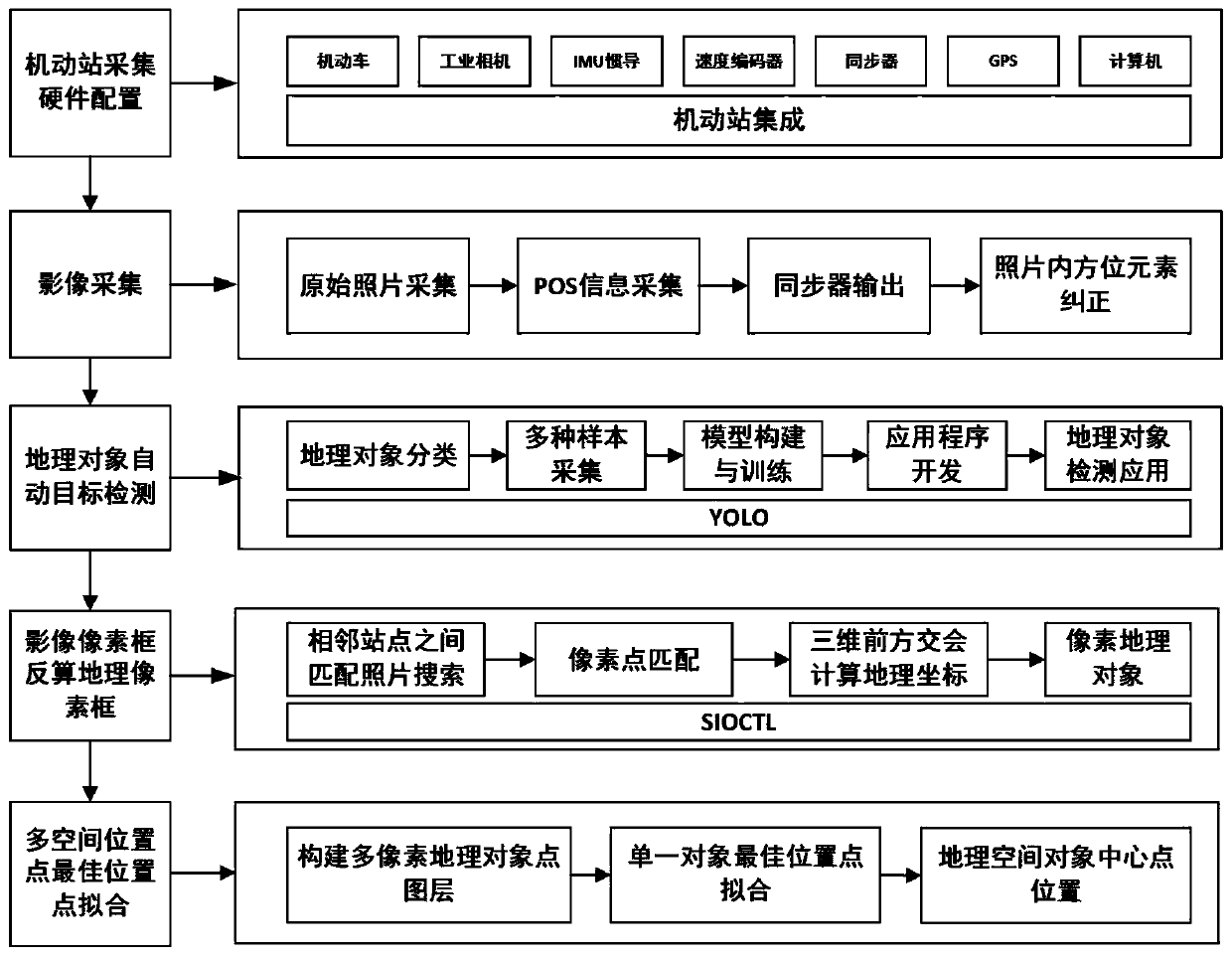
[0058] see figure 1 , a kind of mobile station automatic target detection and spatial positioning method based on YOLO-SIOCTL of the present invention, comprises the following steps:

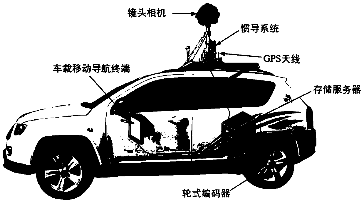
[0059] 1) Mobile station acquisition hardware configuration, such as figure 2 As shown, the present invention uses a motor vehicle as a mobile platform, and integrates cameras, IMUs, speed encoders, synchronizers, GPS and computers to complete automatic detection and positioning of geographic objects.

[0060] In the embodiment, in order to obtain more accurate picture information, the camera adopts a monocular industrial-grade panoramic camera; the high dynamic carrier attitude sensor IMU outputs the real position, speed and attitude of the vehicle body motion through the accelerometer and gyroscope.

[0061] 2) Image acquisition, when the carrier platform of...


PUM


Abstract

The invention discloses a motorized station automatic target detection and spatial positioning method based on YOLO-SIOCTL. The method comprises the following steps that: a mobile station acquires hardware configuration; The carrier platform of the vehicle-mounted mobile measurement system carries out image acquisition in the process of driving at a normal speed; Realizing geographic object automatic target detection based on a YOLO algorithm; back calculation of a geographic pixel frame of the image pixel frame is cahieved based on an SIOCTL algorithm; and a single-object multi-space positionpoint is fitted with an optimal position point. The method can be widely applied to the field of patrol supervision, the workload of manual target checking is effectively reduced, the patrol efficiency is improved, the consumption of manpower and financial resources is reduced, and the method has a good application value in practical application.

Description

technical field [0001] The invention belongs to the technical field of vehicle-mounted mobile measurement, and in particular relates to a method for automatic target detection and space positioning of a mobile station based on YOLO-SIOCTL. Background technique [0002] During inspection and supervision, manual target viewing is usually required, and the inspection efficiency is low. The Vehicle-Borne Mobile Mapping Systems uses the car as a remote sensing platform and installs a high-precision dynamic Global Navigation Satellite System (GNSS ) and a highly dynamic carrier attitude measurement sensor (Inertial Measurement Unit, IMU), based on the GNSS / IMU combined positioning and attitude sensor, the vehicle system has the ability of direct geolocation (Direct Georeferencing, DG). [0003] Combining the theory and engineering application of the mobile vehicle-mounted mapping system can quickly obtain the geographic coordinates of geographic objects and provide method support ...

Claims


Application Information

Patent Timeline
Patent Type & Authority Applications(China)
IPC IPC(8): G06K9/00G06K9/46G06K9/62G01S19/47G01C21/16G01S11/12
CPCY02T10/40
Inventor 陈磊鲍远军江洋刘冰蔡依
Owner NANJING GUOTU INFORMATION IND
Why Eureka
Try Eureka