Novel field geological survey method based on digital outcrops

A digital outcrop and new method technology, applied in the field of geological surveys, can solve problems such as easy deformation and distortion, poor quality of photo stitching, and inability to measure, and achieve the effect of reducing personal safety risks

Inactive Publication Date: 2019-06-21
CHINA UNIV OF PETROLEUM (EAST CHINA)
View PDF3 Cites 6 Cited by
  • Summary
  • Abstract
  • Description
  • Claims
  • Application Information

AI Technical Summary

Problems solved by technology

Traditional field geological surveys mainly record outcrop information by means of on-site measurement and partial photography, which have the following problems: (1) The field survey environment is harsh, and personal safety risks are high; (2) The quality of indoor photo stitching is poor, and it is easy to deform and distort; (3) The accuracy of measuring the length of the reference object as a scale on the map is very low; (4) It is impossible to measure the occurrence elements such as direction, inclination, and tendency indoors
However, the browsing of this outcrop model data requires the installation of special software, and the existing software does not support further geological element measurement and information extraction

Method used


Image

  • Novel field geological survey method based on digital outcrops
  • Novel field geological survey method based on digital outcrops
  • Novel field geological survey method based on digital outcrops

Examples


Embodiment Construction

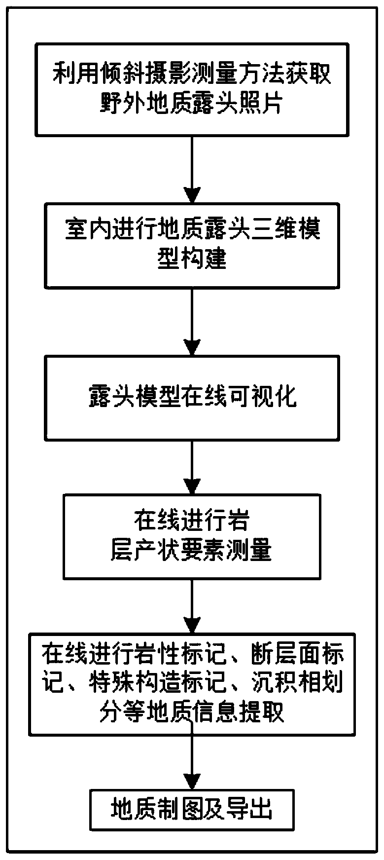
[0028] In order to make the purpose, content, and advantages of the present invention clearer, the specific implementation of the present invention will be described in further detail below in conjunction with the accompanying drawings and embodiments:

[0029] refer to figure 1 , the specific implementation steps of the present invention are:

[0030] (1) Use oblique photogrammetry to obtain photos of geological outcrops in the field;

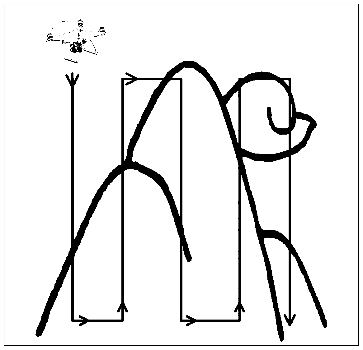
[0031] Among them, when obtaining photos of geological outcrops in the field, a professional drone equipped with a five-lens camera is used to collect photos at a fixed altitude for large-scale flat outcrops; refer to figure 2 , for upright profile outcrops, use a consumer-grade drone equipped with a single-lens camera, and approach the outcrop along a vertical route to collect photos; for small-scale outcrops whose photo resolution cannot meet the requirements, set the scale first Constraint information followed by photo collection using a...


PUM


Abstract

The invention discloses a novel field geological survey method based on digital outcrops. The method includes following basic steps that: oblique photogrammetry is adopted to obtain the picture of a field geological outcrop; the three-dimensional model of the geological outcrop is constructed indoors; the outcrop model is visualized online; online rock stratum attitude element measurement is performed; lithologic marking, fault plane marking, special structural marking, sedimentary facies division and other geological information extraction processing are performed online; and geological mapping is performed, and a geological map is exported. The method provided by the invention is scientific and reasonable, and adopts advanced technologies. According to the novel field geological survey method based on digital outcrops of the invention, the oblique photogrammetry is adopted to acquire the picture of the outcrop, the three-dimensional digital outcrop model is established indoors, and online attitude element measurement and information extraction are performed.

Description

technical field [0001] The invention relates to the field of field geological surveys, in particular to a new field geological survey method which utilizes oblique photogrammetry technology to collect outcrop photos, establishes a three-dimensional digital outcrop model indoors, and performs on-line occurrence element measurement and information extraction. Background technique [0002] Field outcrops are formed by underground rock masses exposed to the surface, and are the most direct, true and detailed data for geological research. Traditional field geological surveys mainly record outcrop information by means of on-site measurement and partial photography, which have the following problems: (1) The environment of field surveys is harsh and the risk of personal safety is high; (2) The quality of indoor photo stitching is poor, and it is easy to deform and distort; (3) The accuracy of measuring the length of the reference object as a scale on the map is very low; (4) It is ...

Claims


Application Information

Patent Timeline
Patent Type & Authority Applications(China)
IPC IPC(8): G01C11/00
Inventor 孔旭旭刘善伟池海旭欧阳志恒周士博王朝段政明
Owner CHINA UNIV OF PETROLEUM (EAST CHINA)
Why Eureka
Try Eureka