Medium-long baseline ambiguity resolution method of adaptive ionosphere estimation model

A technology for estimating models and ionospheres, applied in radio wave measurement systems, satellite radio beacon positioning systems, instruments, etc., can solve problems such as difficult to accurately describe the changing characteristics of the ionosphere, ionosphere irregularities in time and space, etc.

Active Publication Date: 2019-08-23
HARBIN ENG UNIV
View PDF19 Cites 7 Cited by
  • Summary
  • Abstract
  • Description
  • Claims
  • Application Information

AI Technical Summary

Problems solved by technology

However, due to the irregular nature of the ionosphere in space and time, it is difficult for this traditional empirical constraint model to accurately describe the changing characteristics of the ionosphere in the actual environment

Method used


Image

  • Medium-long baseline ambiguity resolution method of adaptive ionosphere estimation model
  • Medium-long baseline ambiguity resolution method of adaptive ionosphere estimation model
  • Medium-long baseline ambiguity resolution method of adaptive ionosphere estimation model

Examples


Embodiment 1

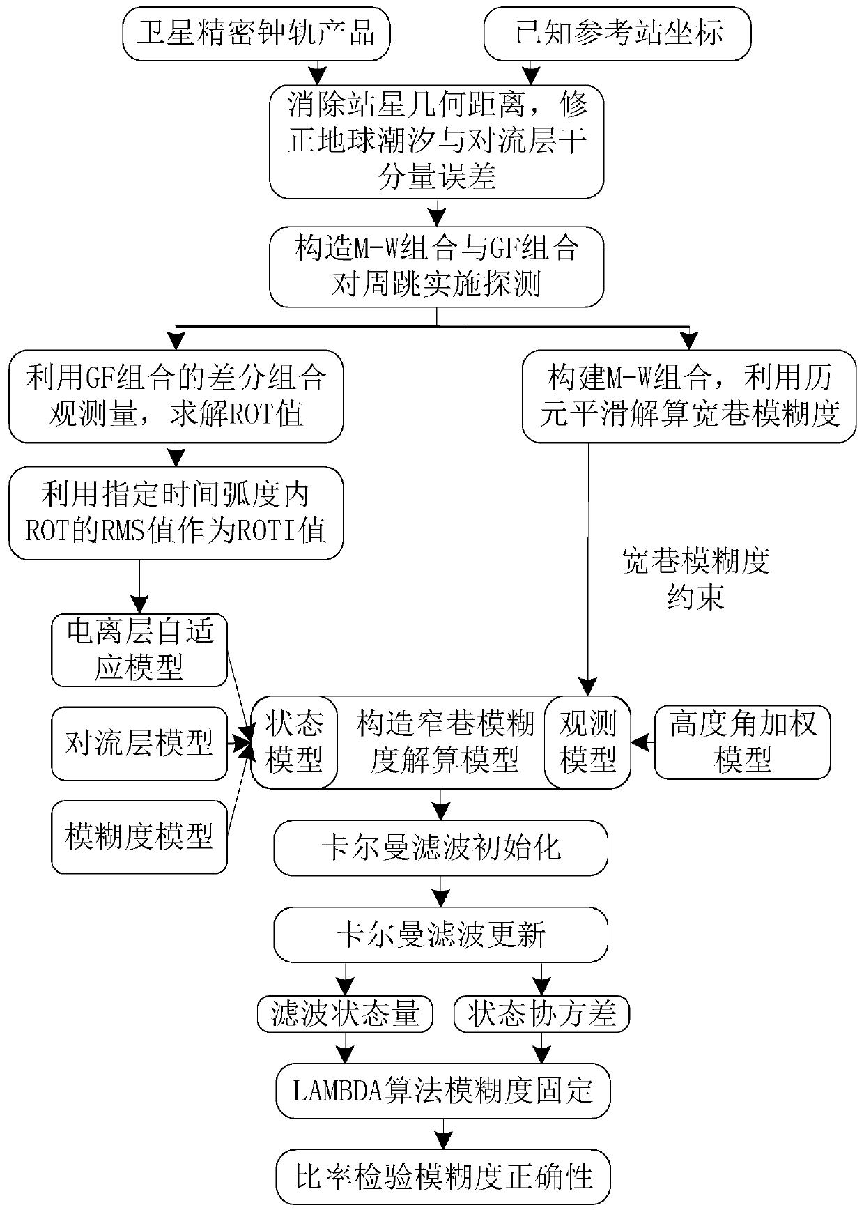
[0045] Step 1, with the help of precise clock orbit products and known reference station coordinates, eliminate the station-satellite geometric distance in the original GNSS observations, and correct the earth tide error and tropospheric dry component error at the same time.

[0046] The Beidou dual-frequency pseudo-range and carrier phase observations correct the station-to-satellite geometric distance, and after the earth fixes the tidal and tropospheric dry components, it can be expressed as:

[0047]

[0048] in and respectively represent the observations of pseudorange and carrier phase; r represents different receivers; s represents different satellite numbers; j corresponds to different frequency points f of Beidou j (j=1,2); Indicates the station-to-satellite geometric distance calculated using known reference station coordinates. d set Indicates the earth solid tide correction for the solution; and Indicates the delay between the dry component and the we...


PUM


Abstract

The invention discloses a medium-long baseline ambiguity resolution method of an adaptive ionosphere estimation model, and belongs to the field of satellite precision navigation and positioning. According to the method, parameters of the ionosphere estimation model are adaptively adjusted by employing ROTI information, and change characteristics of the ionosphere are more accurately described so that the influence of the ionosphere delay error is effectively eliminated, the success rate of medium-long baseline ambiguity resolution can be increased, and the initial fixing time of the ambiguityis shortened; and according to the method, compared with the conventional medium-long baseline ambiguity resolution method based on ionosphere estimation, the performance of ambiguity resolution between reference stations in an NRTK network is enhanced, and the problem of the influence on medium-long baseline ambiguity resolution due to difficult realization of accurate depiction of the change characteristics of the ionosphere in a practical environment by the conventional ionosphere estimation model is solved.

Description

technical field [0001] The invention relates to the field of satellite precision navigation and positioning, in particular to a medium and long baseline ambiguity resolution method for an adaptive ionospheric estimation model. Background technique [0002] Medium and long baseline ambiguity resolution is the key to achieve high-precision positioning in Network real-time kinematic (NRTK) technology. Since the spatial correlation of errors such as ionospheric delay, tropospheric delay, and satellite orbit will weaken with the increase of the inter-station baseline, it is difficult for the NRTK network with an inter-station distance of more than 50 km to solve the ambiguity directly through the inter-station-inter-satellite double difference combination Spend. The ionospheric delay error is difficult to model accurately due to its irregularity in time and space, and becomes the main error source affecting the ambiguity resolution of medium and long baselines. Therefore, accur...

Claims


Application Information

Patent Timeline
Patent Type & Authority Applications(China)
IPC IPC(8): G01S19/44
CPCG01S19/44
Inventor 贾春李亮蒋家昌程建华赵琳
Owner HARBIN ENG UNIV
Why Eureka
Try Eureka