Satellite positioning method based on real-time beacon differential

A real-time differential and satellite positioning technology, applied in the field of global navigation satellite system satellite positioning, can solve problems such as instability and ionospheric delay affecting positioning results

Inactive Publication Date: 2015-03-25
SOUTHEAST UNIV
View PDF4 Cites 26 Cited by
  • Summary
  • Abstract
  • Description
  • Claims
  • Application Information

AI Technical Summary

Problems solved by technology

[0005] Purpose of the invention: Aiming at the above-mentioned existing technologies, a satellite positioning method based on real-time difference o

Method used


Image

  • Satellite positioning method based on real-time beacon differential
  • Satellite positioning method based on real-time beacon differential
  • Satellite positioning method based on real-time beacon differential

Examples


Embodiment Construction

[0036] The present invention will be further described below in conjunction with the accompanying drawings.

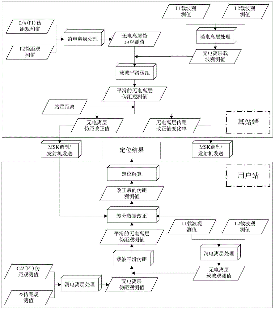
[0037] As shown in the figure, a satellite positioning method based on real-time difference of beacons first uses the pseudo-range observations of the dual-frequency receiver to form the ionosphere-free pseudo-range observations at the base station; then, uses the inter-epoch carrier phase observations Smoothing the ionosphere-free pseudo-range observation value to obtain a smooth ionosphere-free pseudo-range value; then combining the smooth ionosphere-free pseudo-range value with the known station-to-satellite distance to generate an ionosphere-free pseudo-range correction value and its rate of change with time, the ionosphere-free pseudorange correction value and its rate of change with time are encoded and modulated and then transmitted through the transmitter; at the user station, first receive the signal sent by the transmitter and decode After the differential co...


PUM


Abstract

The invention discloses a satellite positioning method based on real-time beacon differential. According to the satellite positioning method based on the real-time beacon differential, in order to solve the problem that ionized layer delay can not be eliminated when a conventional single-frequency beacon positioning method is adopted, the idea that an ionized layer pseudo range eliminating observation value is formed at the base station end by mean of a double-frequency pseudo range observation value is provided; meanwhile, smoothing is conducted on the ionized layer pseudo range eliminating observation value with amplified noise by means of an epoch carrier phase observation value low in noise, a corrected pseudo range value and the rate of change of the corrected pseudo range value along with time are generated according to the known distance between the station and a satellite, coding and sending conducted by means of single-frequency differential data in the prior art are replaced, and the effect of achieving double-frequency positioning by means of the original single-frequency sending technology is achieved. On the user side, a differential correction signal is demodulated through a receiver and is combined with the ionized layer pseudo range eliminating observation value which is received and processed by a user station and is subjected to smoothing for positioning and calculating. By the adoption of the satellite positioning method based on the real-time beacon differential, when the distance between the user station and a differential beacon station reaches 300 km, the planar positioning accuracy can be improved to about 0.15 m from the original 0.65 m.

Description

technical field [0001] The invention relates to a global navigation satellite system (GNSS) satellite positioning method, in particular to a satellite positioning method based on beacon difference. Background technique [0002] With the continuous development of waterway construction, as the pioneer of waterway construction and maintenance——waterway surveying and mapping has become more and more important. Whether it is in the preliminary work, design, construction and post-evaluation stages of waterway engineering construction, or in the waterway maintenance, it is based on the results of waterway surveying and mapping. Waterway surveying and mapping is an important part of waterway production, maintenance and management. Its main content covers a wide range, involves many technologies and management methods, and is closely related to the entire waterway engineering survey. Its main contents include land topographic survey, underwater survey, tide observation and water lev...

Claims


Application Information

Patent Timeline
IPC IPC(8): G01S19/41
CPCG01S19/41
Inventor 高成发高旺生仁军潘树国汪登辉
Owner SOUTHEAST UNIV
Why Eureka
Try Eureka