Enhanced location based services

a technology of location based services and satellite data, applied in satellite radio beaconing, measurement devices, instruments, etc., can solve the problems of slow and problematic collection of ephemeris data from satellites, low data baud rate, and long fix time for gps receivers, so as to achieve fast and effective

Active Publication Date: 2015-10-13
HONEYWELL INT INC
View PDF3 Cites 139 Cited by
  • Summary
  • Abstract
  • Description
  • Claims
  • Application Information

AI Technical Summary

Benefits of technology

[0008]An object of the present invention is to provide location-based data to a pool of devices in a fast and effective manner.
[0009]Another object of the present invention is to generate ephemeris data relevant to the current position of a pool of managed devices and enhanced or extended ephemeris data to improve the positional accuracy of the system as the satellites make predictable movements.
[0010]Another object of the present invention is to create custom almanac data of ephemeris data based and transmit that data to a GPS receiver in an efficient and cost effective manner.

Problems solved by technology

However, this data is a very low baud rate, and is broadcast only—there is no handshake.
Thus, it may take a GPS receiver a long time to achieve a fix.
But collection of the ephemeris data from the satellite can be slow and problematic.
The major drawback to this approach is obtaining the almanac data and delivering the data to the GPS receiver.
Another issue with traditional almanac data is the shelf-life of the data.

Method used


Image

  • Enhanced location based services
  • Enhanced location based services
  • Enhanced location based services

Examples


Embodiment Construction

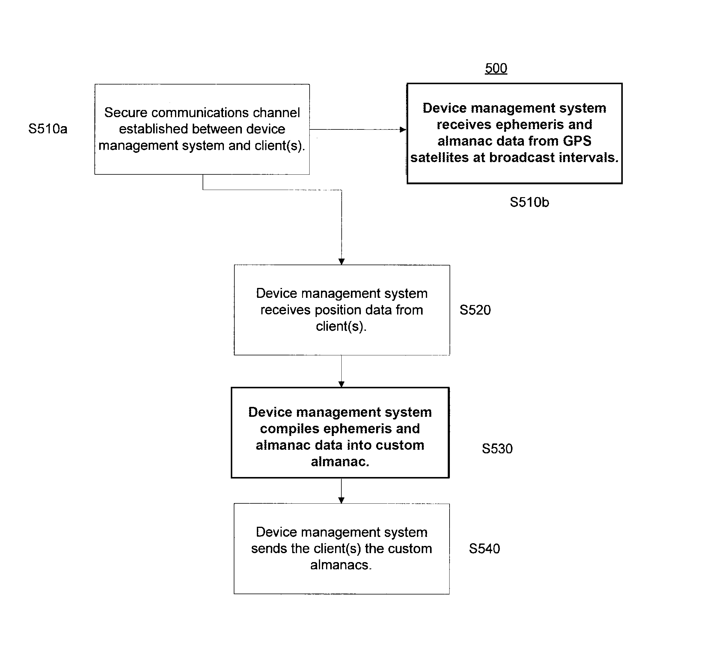
[0026]The present invention provides a system and method to increase the efficiency and accuracy of location-based services.

[0027]The present invention provides a system and method to generate ephemeris data relevant to the current position of a pool of managed devices.

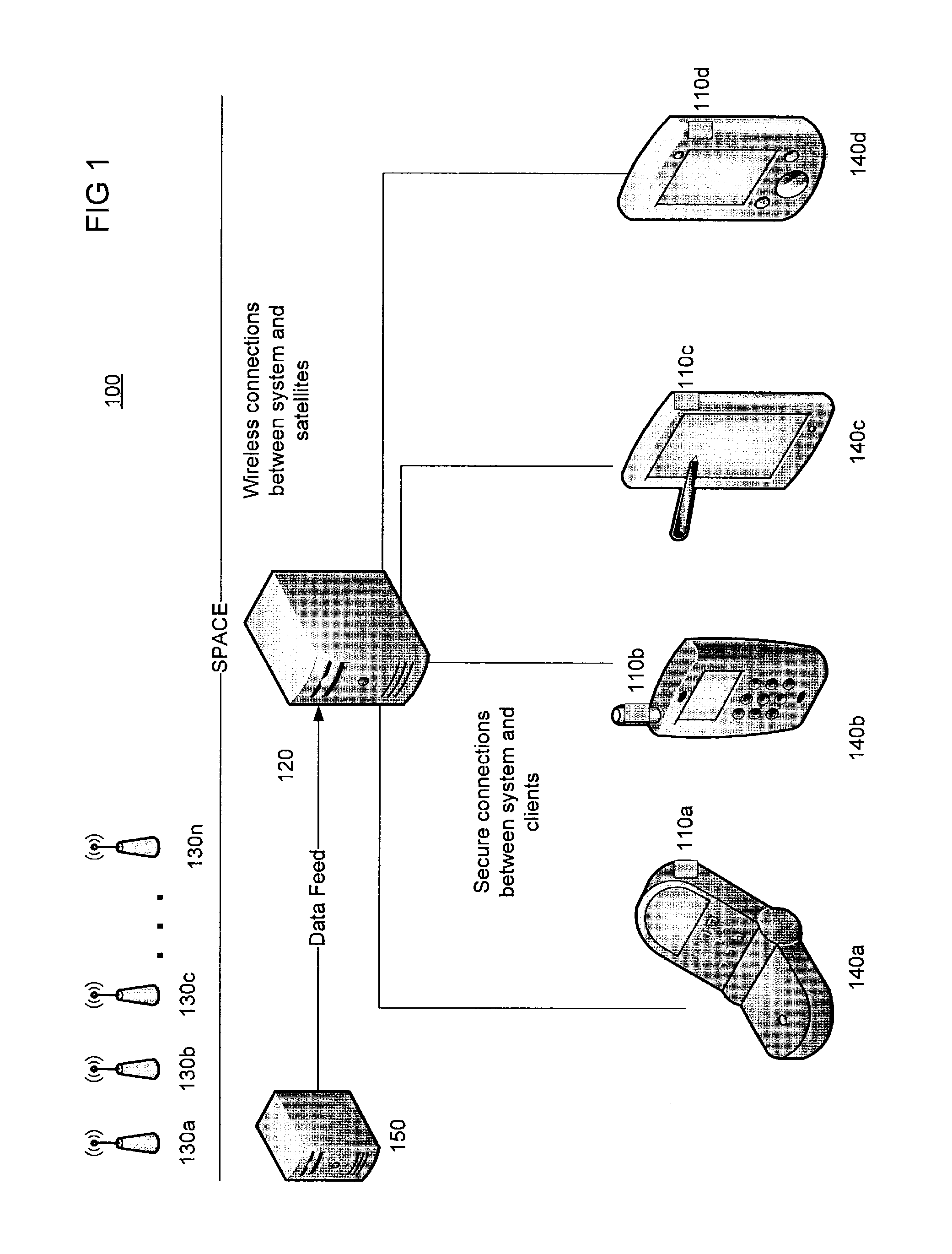
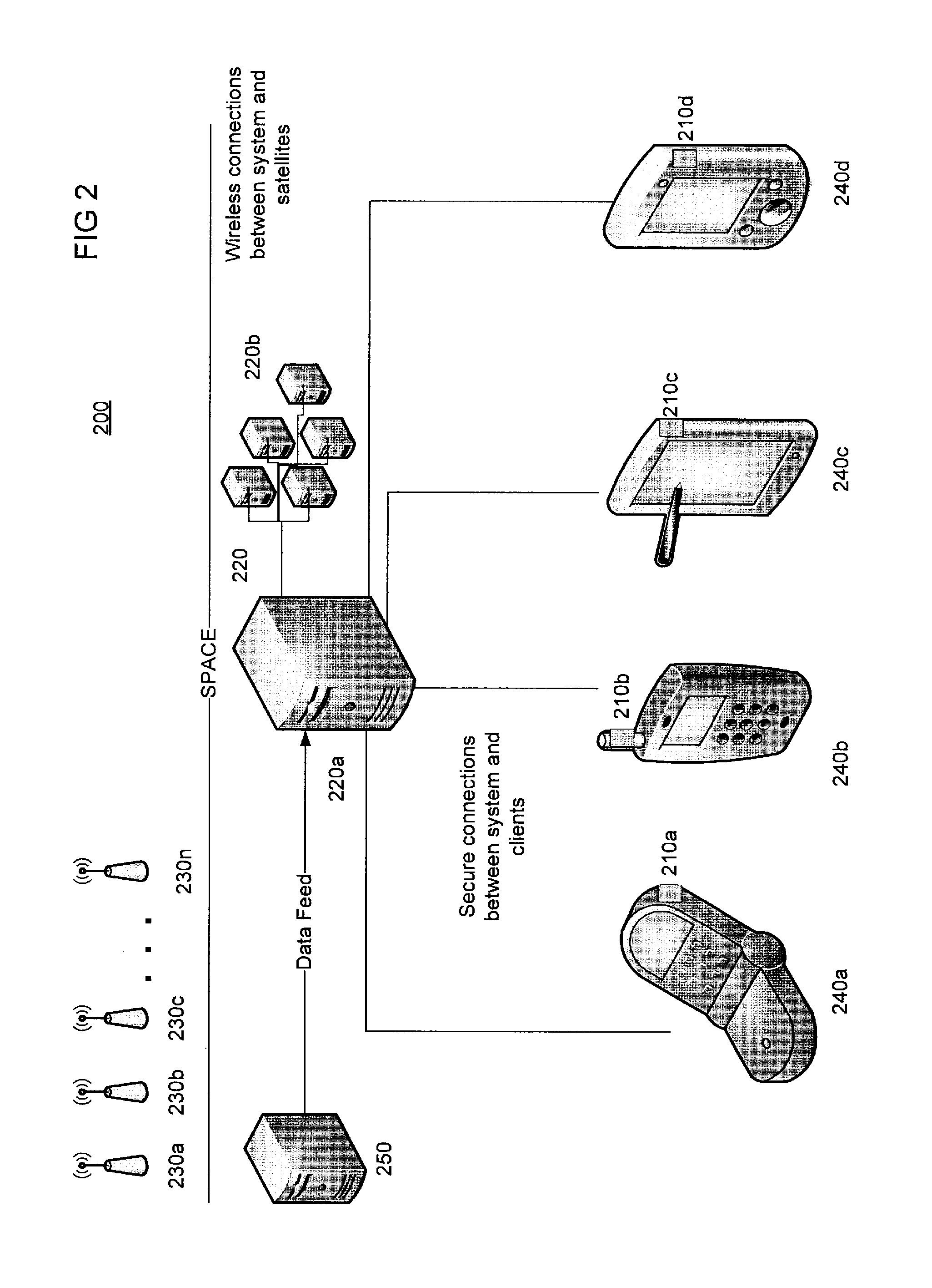
[0028]FIG. 1 depicts a technical architecture 100 of an embodiment of the present invention. The architecture includes a number of client devices 140a-140d integrated with GPS receivers 110a-110d. As aforementioned, GPS receivers refer to devices capable of receiving GPS data. These clients 140a-140d include various devices with integrated GPS reception functionality, including but not limited to, car GPS units, smartphones, personal data terminals, and / or personal GPS units. Although not pictured in FIG. 1, devices also include less traditional devices such as laptops, desktops, servers, and encoded information reading (EIR) terminals, including bar code scanning devices and / or RFID readers, image capture devices.

[00...


PUM


Abstract

A device management system is comprised of a server-side proxy component and at least one back-end computer. The server-side proxy component is configured to receive ephemeris and almanac data from a source and information from at least one client describing the geographic location of the client. The server-side proxy component is configured to send the ephemeris and almanac data and the information from the client to a back-end computer. Responsive to receiving this data and information, the computer compiles it into GPS data relevant to the location of the client.

Description

FIELD OF INVENTION[0001]The present invention provides a system and method to increase the efficiency and accuracy of location-based services.BACKGROUND OF INVENTION[0002]Accuracy and Time To First Fix (TTFF) are critical parameters for any Global Positioning System (GPS) location based service. TTFF is the measure of time required for a GPS receiver to acquire satellite signals and navigation data, and calculate a position solution, which is called a “fix,” a position derived from measuring external reference points.[0003]In a traditional GPS system, the GPS receiver must find the satellites in order to establish a location fix. The satellites and generally, the GPS receiver are in motion, thus there is finite shelf life for the satellite constellation data. Ephemeris and almanac data provide clues as to where the satellites should be for a short term (ephemeris) and longer term (almanac). This data is transmitted by the satellites. However, this data is a very low baud rate, and i...

Claims


Application Information

Patent Timeline
Patent Type & Authority Patents(United States)
IPC IPC(8): G01S19/06
CPCG01S19/06G01S19/27
Inventor SAUERWEIN, JR., JAMES TIMOTHY
Owner HONEYWELL INT INC
Why Eureka
Try Eureka