Method for performing rock classification based on spectral features

A technology of spectral features and rocks, applied in the field of remote sensing image processing, can solve the problem of low lithology accuracy

Inactive Publication Date: 2019-09-20
GUILIN UNIVERSITY OF TECHNOLOGY
View PDF5 Cites 6 Cited by
  • Summary
  • Abstract
  • Description
  • Claims
  • Application Information

AI Technical Summary

Benefits of technology

The technical effect of this patented technology allows for accurate analysis of rock samples that contain multiple materials such as clay mineral or organic matter without being able to distinguish between these types accurately based solely upon their spectra alone. This makes it possible to make more precise comparisons across all kinds of rocks compared against traditional methods like X-ray diffraction (XR) which only work well within specific compositions/lithologies.

Problems solved by technology

This patents describes various techniques that have been developed over past decades by researchers working at home or abroad about identifying certain types of materials called stones from remotely observed imagery (R). However these existing approaches require significant human effort and resource allocation due to their manual process. There also exist challenges such as requiring long periods of observation before accurate results may appear.

Method used


Image

  • Method for performing rock classification based on spectral features
  • Method for performing rock classification based on spectral features
  • Method for performing rock classification based on spectral features

Examples


Embodiment

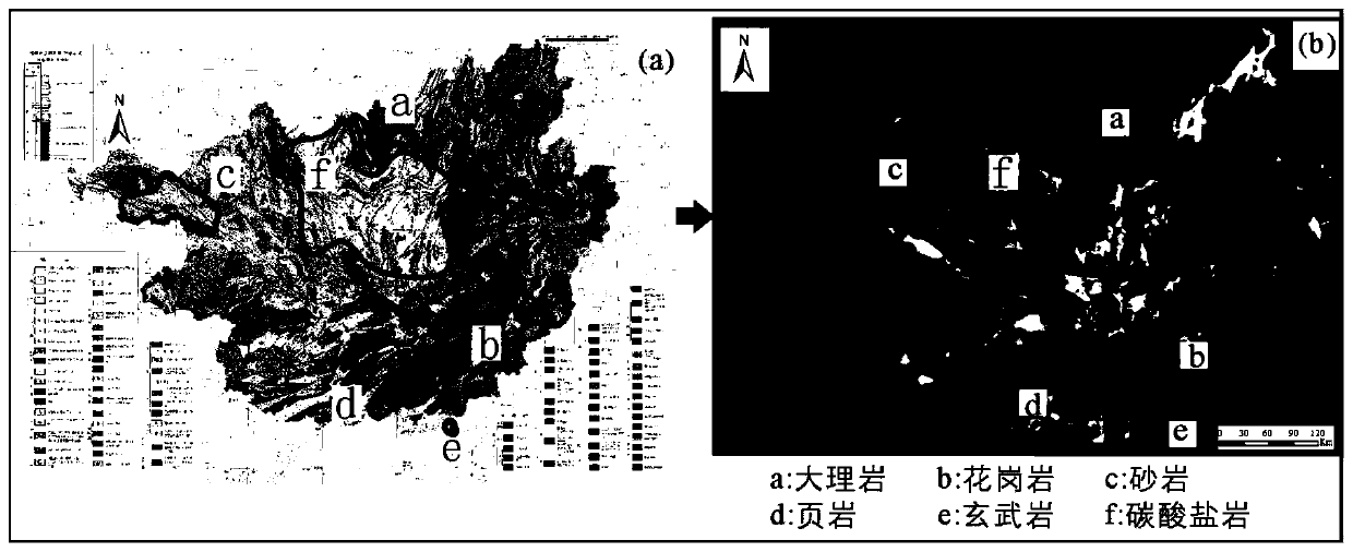
[0021] In this example, we select images of Guangxi (typical karst landform) for lithology classification. The image is Landsat 7ETM+, combined with a 1:200,000 geological map of Guangxi and rock samples from the training area.

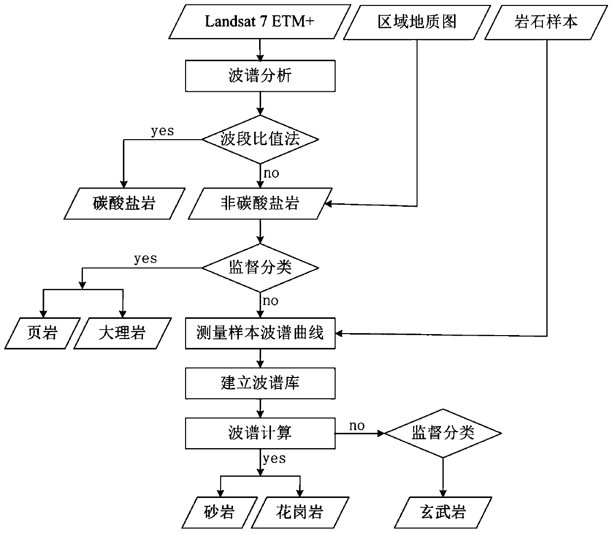
[0022] In the specific implementation, the specific operation steps of the method provided by the present invention can be described in the technical roadmap ( figure 1 ).

[0023] Step 1. First, prepare the data, download the Landsat 7ETM+ image, prepare the 1:200,000 geological map of Guangxi, collect rock samples in the training area, and perform a series of preprocessing work on the Landsat 7ETM+ image, such as repairing bad track atmosphere and geometric correction, etc. .

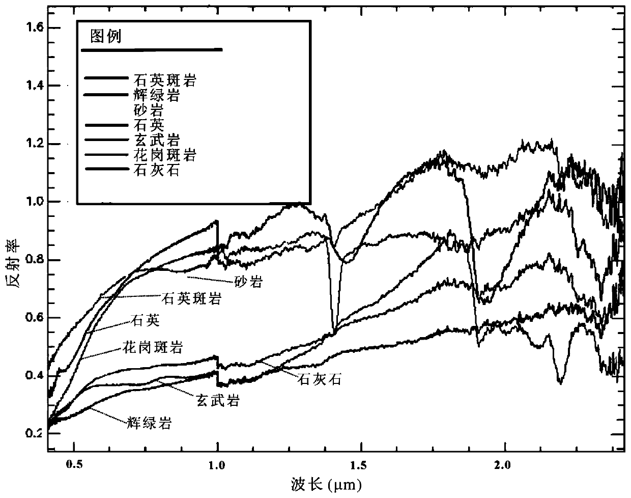
[0024] Step 2, perform spectral analysis, and extract carbonate rocks by band ratio method. The spectra of the main minerals in carbonate rocks, that is, calcite and dolomite, are relatively flat between 1.545-1.755 μm, and have obvious absorption peaks between 2.075-2.351...


PUM


Abstract

The invention discloses a method for performing rock classification based on spectral features. The method comprises: step one, carrying out spectrum analysis on carbonate rocks by using a band ratio method; step two, establishing a training zone by combining a geological map and spectral features and classifying shale and marble based on a supervised classification method; step four, establishing a spectrum library by using spectrums of rock samples and supplementing spectral features of rocks in an implementing area by combining a USGS spectral library; step four, carrying out spectrum analysis and calculation and classifying sandstones and granite; and step five, carrying out supervised classification by using a minimum distance classification method to realize classification of other rocks in the remaining area. Therefore, a problem of low geological map interpretation by using a remote sensing image in a difficult remote sensing interpretation area, especially a karst area is solved.

Description


Claims


Application Information

Patent Timeline
Owner GUILIN UNIVERSITY OF TECHNOLOGY
Why Eureka
Try Eureka