Multi-camera group cooperative acquisition holder and control system thereof

A control system and unit control technology, applied in the field of geographic information aerial survey, can solve the problems of prohibitive price and consumption of large manpower and material resources.

Inactive Publication Date: 2019-11-01
武汉大势智慧科技有限公司
View PDF8 Cites 12 Cited by
  • Summary
  • Abstract
  • Description
  • Claims
  • Application Information

AI Technical Summary

Problems solved by technology

[0005] Aiming at the deficiencies of the prior art, the present invention provides a multi-camera group collaborative acquisition pan-tilt and its control system, which solves the problem that there is only one camera group on the existing pan-tilt, and in order to meet the requirements of ultra-high-precision aerial survey, it needs to be replaced with a higher Pixel cameras, either need multiple sorties to fly repeatedly, and the price of ultra-high-resolution cameras is prohibitive, and repeated flights will consume a lot of manpower and material resources.

Method used


Image

  • Multi-camera group cooperative acquisition holder and control system thereof
  • Multi-camera group cooperative acquisition holder and control system thereof

Examples


Embodiment Construction

[0026] The following will clearly and completely describe the technical solutions in the embodiments of the present invention with reference to the accompanying drawings in the embodiments of the present invention. Obviously, the described embodiments are only some, not all, embodiments of the present invention. Based on the embodiments of the present invention, all other embodiments obtained by persons of ordinary skill in the art without making creative efforts belong to the protection scope of the present invention.

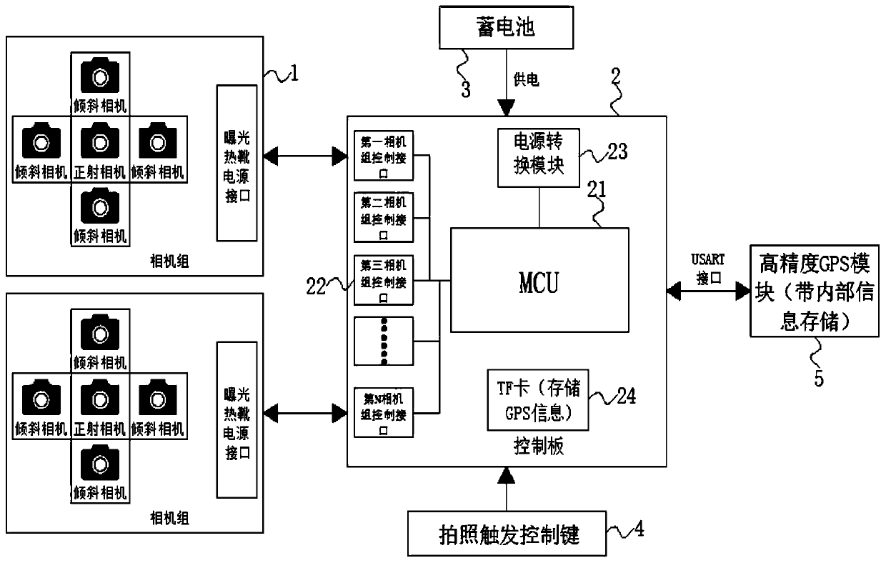
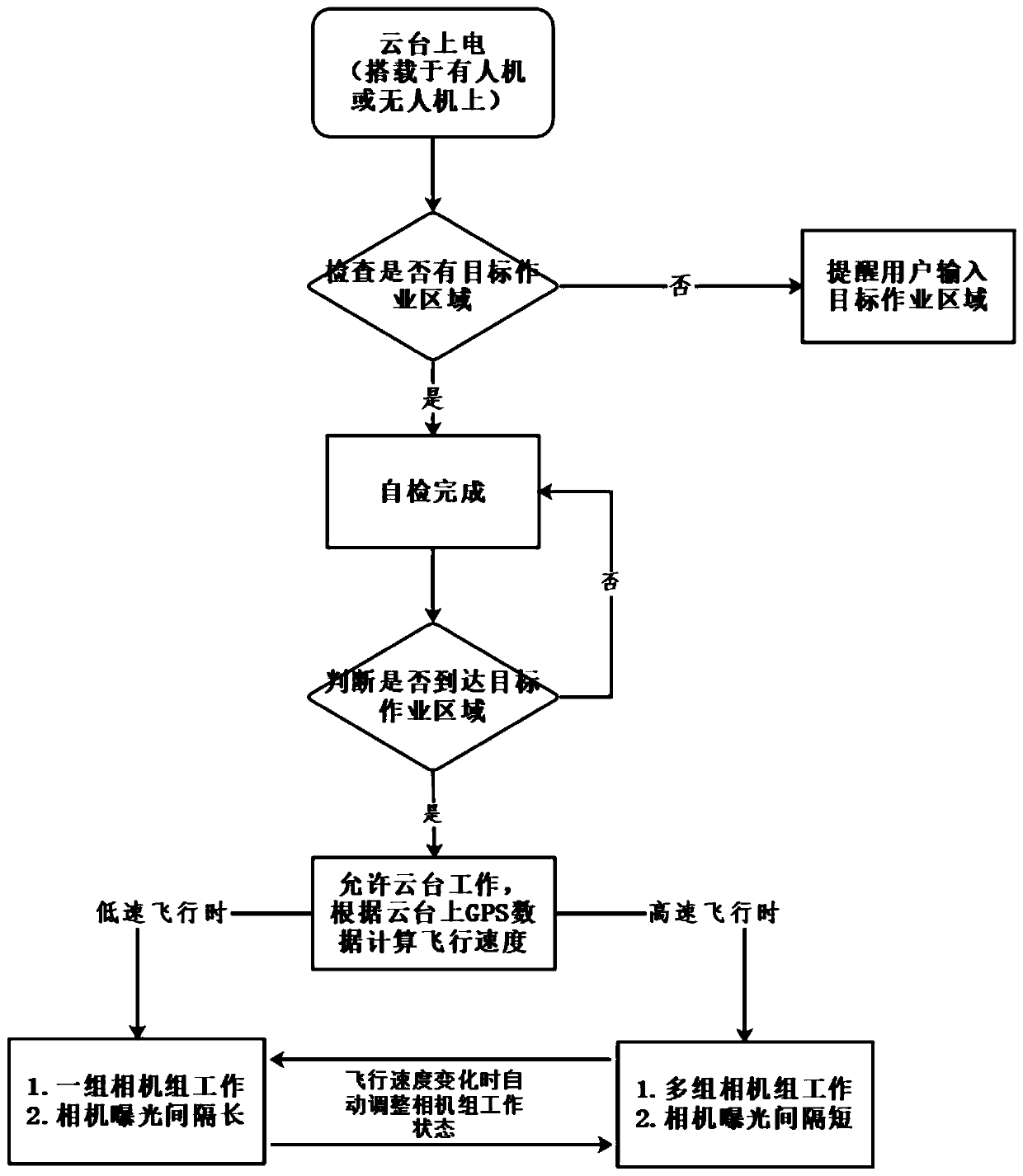
[0027] see Figure 1-2 , the embodiment of the present invention provides a technical solution: a multi-camera group cooperative acquisition pan-tilt and its control system, including a camera group 1, a control board 2, a storage battery 3, a camera trigger control key 4 and a high-precision GPS module 5, which It is characterized in that: the control board 2 includes MCU21, camera group control interface 22, power conversion module 23 and TF card 24, and the...


PUM


Abstract

The invention discloses a multi-camera set cooperative acquisition holder and a control system thereof. Themulti-camera set cooperative acquisition holder comprises camera sets, a control panel, a storage battery, a photographing trigger control key and a high-precision GPS module. The control panel comprises an MCU, camera set control interfaces, a power supply conversion module and a TF card. The wiring end of the MCU is electrically connected with the wiring ends of the camera setcontrol interface, the power supply conversion module and the TF card through wires. The number of the camera sets and the number of the camera set control interfaces are both N. The invention relates to the field of geographic information aerial survey technology. By means of thecooperative acquisition holderand the control system thereof, thecamera set composed of an orthographic camera and a plurality of oblique cameras can be realized. A high-precision GPS module is carried on the holder, so that the control system of the holder can automatically identify a planned operation area and calculate the flight speed of an airplane. The working number of camera sets is controlled and the shooting time interval of the camera sets is adjusted to meet the requirement for the heading overlapping degree of aerial photos.

Description

technical field [0001] The invention relates to the technical field of geographic information aerial survey, in particular to a multi-camera group cooperative collection platform and a control system thereof. Background technique [0002] Geographical information is the geographical meaning contained and expressed by geographic data, and it is the general term for numbers, texts, images and graphics related to the quantity, quality, nature, distribution characteristics, connections and laws of substances related to geographical environmental elements. Belonging to spatial information, the identification of its location is associated with data, which is the most significant sign (spatiality) that distinguishes geographic information from other types of information. Secondly, geographic information has the characteristics of multidimensional structure (multidimensionality). Thirdly, the timing characteristics of geographic information are obvious (chronological). When acquirin...

Claims


Application Information

Patent Timeline
Patent Type & Authority Applications(China)
IPC IPC(8): G03B15/00G03B37/04H04N5/235G05B19/042G01S19/14
CPCG03B15/006G03B37/04G05B19/0423G01S19/14H04N23/73
Inventor 刘亮亮刘湘泉
Owner 武汉大势智慧科技有限公司
Why Eureka
Try Eureka