Polar sea area ice condition fusion display method

A technology that integrates display and ice conditions. It is applied to geographic information databases, editing/combining graphics or text, and instruments. Issues such as ice density and depth information

Active Publication Date: 2019-11-12
SHANGHAI MARITIME UNIVERSITY
View PDF2 Cites 6 Cited by
  • Summary
  • Abstract
  • Description
  • Claims
  • Application Information

AI Technical Summary

Problems solved by technology

[0003] At present, because the open map platforms Baidu Maps, Google Maps, and Mapbox default to the Mercator projection, which lacks polar projections, developers lack layer information in polar seas, and there is no APP to display and analyze and predict ice conditions in polar seas. Clearly understand the density and depth of sea ice around the ship
Due to the lack of navigation and path planning systems suitable for polar seas, the choice of routes for ships navigating in polar ice regions is largely based on the experience of navigators, and the safety of navigation cannot be effectively guaranteed

Method used


Image

  • Polar sea area ice condition fusion display method
  • Polar sea area ice condition fusion display method
  • Polar sea area ice condition fusion display method

Examples


Embodiment Construction

[0011] The specific embodiments of the present invention will be further described below in conjunction with the accompanying drawings.

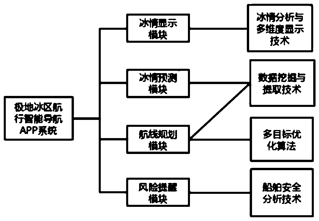
[0012] Such as figure 1 As shown, an intelligent navigation APP system suitable for polar sea navigation in polar ice areas is formed by combining technologies such as fusion display of ice conditions in polar seas, data mining and extraction technology, multi-objective optimization algorithm, and data-driven ship safety analysis technology.

[0013] Such as figure 1 As shown, the ice display module uses ArcGIS to define the projection of the complete polar map picture, so that the picture has spatial location information, and uses EPSG:3571 to set the projection. By adding location points, the geographic location name corresponds to the latitude and longitude, and the data is checked. Stop adding when the latitude and longitude error is less than 0.0001 degrees, and complete the calibration of latitude and longitude accuracy. Use the addr...


PUM


Abstract

The invention discloses a polar sea area ice condition fusion display method, and the method comprises the steps: carrying out the data processing and image processing of collected sea ice intensity and sea ice thickness data of a polar sea area target, extracting the effective information of each channel, and synthesizing the effective information into a high-quality sea ice information image; wherein the saturation of the color represents the sea ice density and the sea ice depth, so that the sea area ice condition information is clear at a glance. A model is established through a causal influence network algorithm, the sea ice density and the sea ice thickness are predicted, future sea area ice condition information is provided, time universality is achieved, and meanwhile the superimposed chart is a necessary premise for polar navigation route planning.

Description

technical field [0001] The invention relates to the field of intelligent navigation, in particular to an ice fusion display method suitable for polar sea areas. Background technique [0002] In recent years, the global climate has been warming day by day, which has led to the melting of sea ice in the Arctic and Antarctic and rising sea levels. At the same time, in summer, the conditions in the polar seas are already sufficient for the normal passage of ships. With the development of ice-breaking technology and ship technology, the voyages from my country to the east coast of North America through the "Northwest Route" and the voyage to Europe through the "Northeast Route" will be greatly shortened, saving the transportation cost of ships. The rich mineral resources in the polar regions have attracted scientific expedition teams from all over the world to explore. In recent years, more and more ships have begun to sail to the polar seas. [0003] At present, due to the ope...

Claims


Application Information

Patent Timeline
Patent Type & Authority Applications(China)
IPC IPC(8): G06F16/29G06T11/60G06F16/2458G06F16/248
CPCG06F16/29G06T11/60G06F16/2465G06F16/248
Inventor 刘卫李元光谢宗轩胡媛王胜正赵建森
Owner SHANGHAI MARITIME UNIVERSITY
Why Eureka
Try Eureka