Satellite positioning method, device, computer equipment and storage medium for high-altitude equipment

A high-altitude equipment and satellite positioning technology, which is applied in the field of satellite positioning, can solve the problems of large positioning errors, low accuracy of satellite positioning of high-altitude equipment, and large differences

Active Publication Date: 2022-07-12
ALLYSTAR TECH SHENZHEN CO LTD
View PDF15 Cites 0 Cited by
  • Summary
  • Abstract
  • Description
  • Claims
  • Application Information

AI Technical Summary

Problems solved by technology

[0003] However, in the application of atmospheric physical observation for satellite positioning of high-altitude equipment, such as navigational radiosondes, the high-altitude observation environment of the high-altitude equipment is quite different from the traditional ground observation environment, and the positioning error is large, resulting in the satellite positioning of the high-altitude equipment. Positioning accuracy is low

Method used


Image

  • Satellite positioning method, device, computer equipment and storage medium for high-altitude equipment
  • Satellite positioning method, device, computer equipment and storage medium for high-altitude equipment
  • Satellite positioning method, device, computer equipment and storage medium for high-altitude equipment

Examples


Embodiment Construction

[0058] In order to make the purpose, technical solutions and advantages of the present application more clearly understood, the present application will be described in further detail below with reference to the accompanying drawings and embodiments. It should be understood that the specific embodiments described herein are only used to explain the present application, but not to limit the present application.

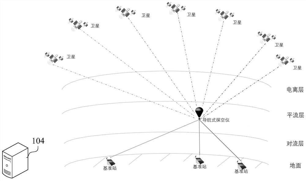
[0059] The satellite positioning method of the high-altitude equipment provided by this application can be applied to such as figure 1 The sonde satellite positioning application environment shown. Among them, the high-altitude equipment is the navigation-type sonde in the high-altitude weather detection. There are multiple reference stations on the ground. Both the navigation-type sonde and the reference station can observe satellites. The navigation-type sonde and the reference station are connected to the server respectively. 104 communicates over a network. The h...


PUM


Abstract

The present application relates to a satellite positioning method, device, computer equipment and storage medium for high-altitude equipment. The method includes: acquiring the equipment observation data of the high-altitude equipment to be positioned; determining the approximate position of the high-altitude equipment according to the equipment observation data; Corresponding base station observation data; according to the equipment observation data and base station observation data, determine the common-view satellites corresponding to the high-altitude equipment and each target base station; the common-view satellite is the satellite observed by the high-altitude equipment and the target base station; the observation from the equipment The common-view satellite observation data corresponding to each common-view satellite is determined from the data and the base station observation data, and the satellite positioning data of the high-altitude equipment is obtained according to the common-view satellite observation data. By adopting the method, the satellite positioning accuracy of high-altitude equipment can be improved.

Description

technical field [0001] The present application relates to the technical field of satellite positioning, and in particular, to a satellite positioning method, apparatus, computer equipment and storage medium for high-altitude equipment. Background technique [0002] Satellite positioning is a technology that uses satellites to accurately locate something. Specifically, by using the two-way communication between satellites and receivers to determine the position of the receiver, it can provide users with accurate position coordinates and related attributes in real time on a global scale. feature. At present, the realization of satellite positioning includes Global Positioning System (Global Positioning System, GPS), Global Navigation Satellite System (Global Navigation Satellite System, GNSS), BeiDou Navigation Satellite System (BeiDou Navigation Satellite System, BDS) and so on. Satellite positioning technology is widely used in vehicle navigation, emergency response, atmosp...

Claims


Application Information

Patent Timeline
Patent Type & Authority Patents(China)
IPC IPC(8): G01S19/42
CPCG01S19/42G01S19/428Y02A90/10
Inventor 高星伟马元杜聪慧董建军
Owner ALLYSTAR TECH SHENZHEN CO LTD
Why Eureka
Try Eureka