
Method for positioning precision enhancement of GNSS, and GNSS positioning system

A positioning accuracy and high-precision technology, applied in the field of satellite navigation and positioning, to achieve the effect of low cost of use, improvement of satellite positioning accuracy, and simple structure

Inactive Publication Date: 2016-05-25
SOUTHEAST UNIV
View PDF6 Cites 12 Cited by
  • Summary
  • Abstract
  • Description
  • Claims
  • Application Information

AI Technical Summary

Problems solved by technology

[0005] The technical problem to be solved by the present invention is to overcome the deficiencies of the existing technologies, provide a GNSS positioning accuracy enhancement method and a GNSS positioning system, which can better solve the high-precision positioning requirements and low The contradiction between the cost of use

Method used


Image

  • Method for positioning precision enhancement of GNSS, and GNSS positioning system

Examples


Embodiment Construction

[0016] The technical scheme of the present invention is described in detail below in conjunction with accompanying drawing:

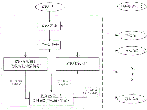
[0017] The idea of ​​the present invention is to use a GNSS receiver with satellite positioning enhancement function to obtain the high-precision coordinates of the reference station itself, and at the same time use a GNSS receiver without satellite positioning enhancement function to receive the original star observation data (common satellite positioning signal), and then transmit the differential data between the two to other mobile terminals through the communication link. The mobile terminal only needs a GNSS receiver without satellite positioning enhancement function to receive the original star observation data, and then use the differential data to It can be corrected to obtain its own high-precision coordinates.

[0018] The above-mentioned satellite positioning enhancement can be ground-based enhancement or satellite-based enhancement;

[001...


PUM


Abstract

The invention, which belongs to the field of the satellite navigation positioning technology, discloses a method for positioning precision enhancement of a global navigation satellite system (GNSS). The system is characterized in that a GNSS receiver having a satellite positioning enhancement function is used for obtaining a high-precision coordinate of a base station; a GNSS receiver not having a satellite positioning enhancement function is used for receiving original satellite observation data; and differential data between high-precision coordinate and the data are transmitted to another mobile terminal by a communication link. The mobile terminal only needs a GNSS receiver not having a satellite positioning enhancement function to receive the original satellite observation data; and then correction is carried out based on the differential data, thereby obtaining a high-precision coordinate. In addition, the invention also discloses a GNSS positioning system. Therefore, the requirement of GNSS receiver usage in batches on an application occasion can be met; and the conflict between the high-precision positioning requirement and low application cost can be eliminated.

Description

technical field [0001] The invention relates to a GNSS (Global Navigation Satellite System, Global Navigation Satellite System) positioning accuracy enhancement method, which belongs to the technical field of satellite navigation and positioning. Background technique [0002] GNSS refers to all satellite navigation systems, including global, regional and augmented, such as GPS in the United States, Glonass in Russia, Galileo in Europe, Beidou satellite navigation system in China, and related augmentation systems such as WAAS in the United States (Wide Area Augmentation System), Europe's EGNOS (European Geostationary Navigation Overlay System) and Japan's MSAS (Multifunctional Transportation Satellite Augmentation System), etc., also covers other satellite navigation systems under construction and to be built in the future. With the continuous development of satellite navigation technology, satellite navigation and positioning technology has increasingly entered our life and ...

Claims


Application Information

Patent Timeline
Patent Type & Authority Applications(China)
IPC IPC(8): G01S19/13G01S19/42
CPCG01S19/13G01S19/42
Inventor 王庆蒋新源张勇李娜
Owner SOUTHEAST UNIV
Learn More