Unlock instant, AI-driven research and patent intelligence for your innovation.

Cross-platform vector map element symbol rendering method and device based on QGIS

A vector map and cross-platform technology, applied in the field of computer map drawing, can solve the problem that symbols are difficult to use on other platforms, and achieve the effect of good independence and strong cross-platform ability

Pending Publication Date: 2020-05-29
GUANGZHOU SOUTH SATELLITE NAVIGATION INSTR
View PDF0 Cites 2 Cited by
  • Summary
  • Abstract
  • Description
  • Claims
  • Application Information

AI Technical Summary

Problems solved by technology

[0005] Therefore, symbols designed using one system or platform are difficult to use on other platforms, and drawing on different platforms requires redesign and production of symbols

Method used


Image

  • Cross-platform vector map element symbol rendering method and device based on QGIS
  • Cross-platform vector map element symbol rendering method and device based on QGIS
  • Cross-platform vector map element symbol rendering method and device based on QGIS

Examples


Embodiment Construction

[0034] Below, the present invention will be further described in conjunction with the accompanying drawings and specific implementation methods. It should be noted that, under the premise of not conflicting, the various embodiments described below or the technical features can be combined arbitrarily to form new embodiments. .

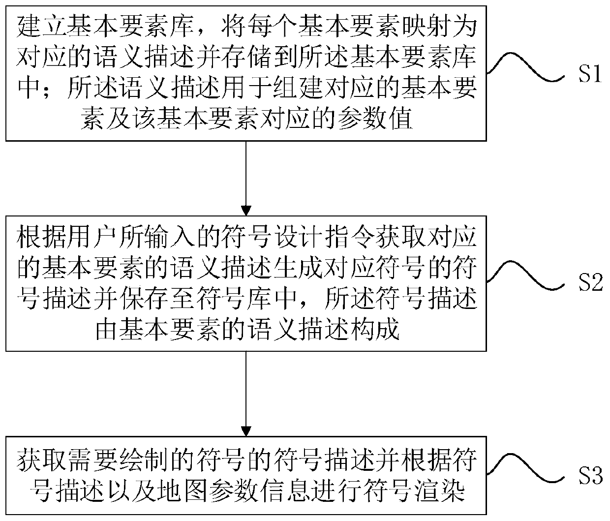
[0035] see figure 1 and figure 2 , a QGIS-based cross-platform vector map feature symbol rendering method, comprising the following steps:

[0036] S1. Establish a basic element library, map each basic element into a corresponding semantic description and store it in the basic element library; the semantic description is used to build the corresponding basic element and the parameter value corresponding to the basic element; The basic elements include point, simple line, dot-dash line, width gradient line, double line, simple surface, filled point and filled line; the basic elements are mapped by semantic description, and each element is mapped to t...


PUM


Abstract

The invention discloses a cross-platform vector map element symbol rendering method and device based on QGIS, and the method comprises the following steps: building a basic element library, enabling each basic element to be mapped into a corresponding semantic description, and storing the semantic description in the basic element library, wherein the semantic description is used for establishing corresponding basic elements and parameter values corresponding to the basic elements; obtaining semantic description of corresponding basic elements according to a symbol design instruction input by auser to generate symbol description of corresponding symbols, and storing the symbol description into a symbol library, wherein the symbol description is composed of the semantic description of the basic elements; and acquiring symbol description of a symbol to be drawn, and performing symbol rendering according to the symbol description and the map parameter information. According to the method,on the basis of a symbol rendering framework of the QGIS, symbol design and rendering are completely separated by utilizing powerful rendering logic and a layer management mechanism of the QGIS, symbols are designed in a symbol description mode, the symbols can be independently designed and edited, the independence is good, and the cross-platform capability is high.

Description

technical field [0001] The invention relates to the field of computer map drawing, in particular to a QGIS-based cross-platform vector map element symbol rendering method and device. Background technique [0002] Map symbols are the basic means to express the content of maps. They can not only express the spatial position, shape, quality and quantity characteristics of things, but also express the interrelationships between things and the overall characteristics of regions. It is the language of maps. [0003] Symbol design is a crucial step in map making. The symbol design system mainly includes the definition of basic symbols, the definition of combination methods, and the design of key technologies such as symbol rendering. [0004] Many symbol design systems currently on the market divide symbols into points, lines, and planes for separate design. Point symbols are determined by parameters such as size, color, and shape; line symbols are determined by broadband, dotted l...

Claims


Application Information

Patent Timeline
Patent Type & Authority Applications(China)
IPC IPC(8): G06F16/29
CPCG06F16/29
Inventor 黄海锋闫志愿丁永祥文述生王江林李宁周光海肖浩威黄劲风马原徐丹龙杨艺马然闫少霞庄所增潘伟锋张珑耀刘国光郝志刚陶超韦锦超赵瑞东潘军兆陈奕均
Owner GUANGZHOU SOUTH SATELLITE NAVIGATION INSTR