Remote sensing texture information determination method and device, terminal and storage medium

A technology of texture information and determination method, applied in the field of remote sensing information processing, can solve the problems of inability to accurately describe the features of elements and restrict the accuracy of remote sensing classification.

Pending Publication Date: 2020-10-20
CHINA UNIV OF GEOSCIENCES (WUHAN)
View PDF0 Cites 0 Cited by
  • Summary
  • Abstract
  • Description
  • Claims
  • Application Information

AI Technical Summary

Problems solved by technology

However, the traditional way of determining texture information does not make full use of terrain features, so that the traditional remote sensing texture information classification and representation model cannot accurately describe the characteristics of these surface mining system elements in mining areas, which restricts the improvement of remote sensing classification accuracy

Method used


Image

  • Remote sensing texture information determination method and device, terminal and storage medium
  • Remote sensing texture information determination method and device, terminal and storage medium
  • Remote sensing texture information determination method and device, terminal and storage medium

Examples


Embodiment Construction

[0034] In order to make the above objects, features and advantages of the present invention more comprehensible, specific embodiments of the present invention will be described in detail below in conjunction with the accompanying drawings.

[0035] The invention proposes a method for determining remote sensing texture information.

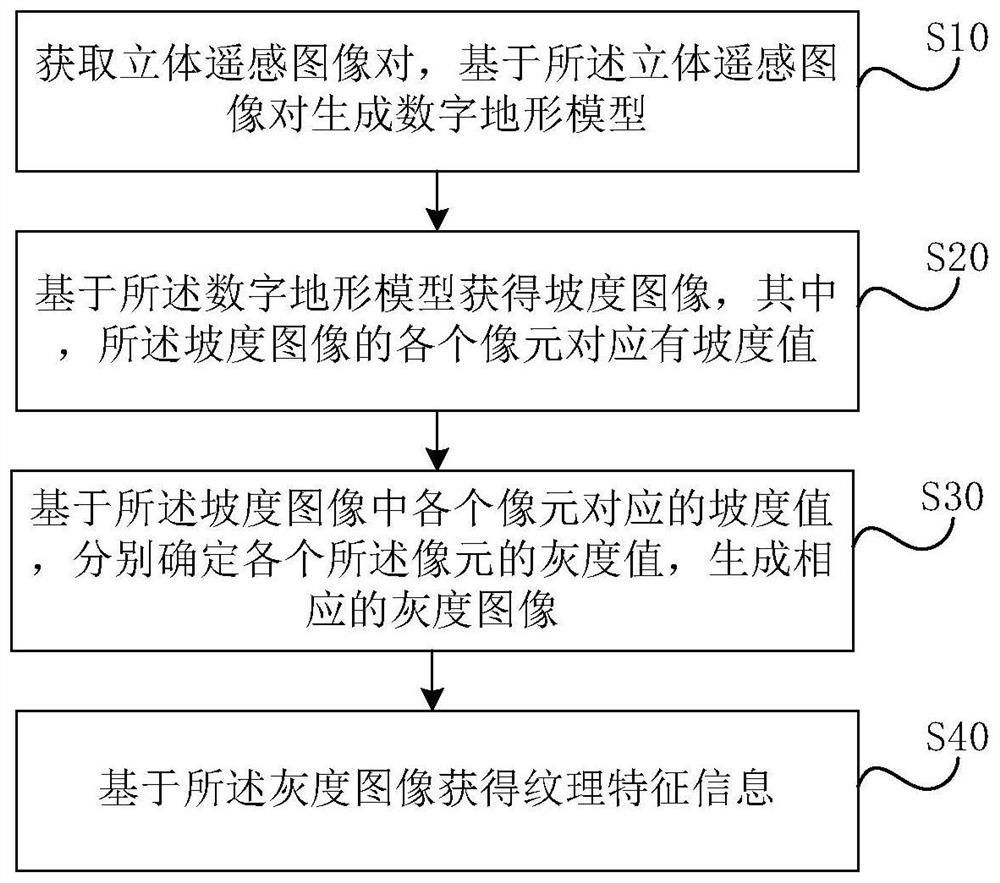
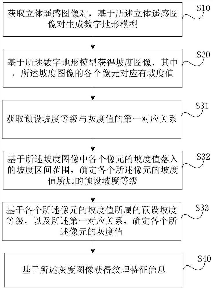
[0036] figure 1 It is a schematic diagram of an embodiment of the method for determining remote sensing texture information of the present invention. Such as figure 1 , the method for determining remote sensing texture information includes:

[0037] Step S10, acquiring a pair of stereo remote sensing images, and generating a digital terrain model based on the pair of stereo remote sensing images;

[0038] The stereo remote sensing image pair here refers to the stereo image pair of different angles in the same area, which can be selected as the high spatial resolution stereo surveying and mapping satellite remote sensing image in the same area, f...


PUM


Abstract

The invention provides a remote sensing texture information determination method and device, a terminal and a storage medium, and the remote sensing texture information determination method comprises:obtaining a three-dimensional remote sensing image pair, and generating a digital terrain model based on the three-dimensional remote sensing image pair; obtaining a gradient image based on the digital terrain model, wherein each pixel of the gradient image corresponds to a gradient value; based on the gradient value corresponding to each pixel in the gradient image, determining the gray value ofeach pixel, and generating a corresponding gray image; and obtaining texture feature information based on the grayscale image. The texture feature/information extracted by the method is more accurateand finer, so that the classification precision based on the texture feature/information is improved.

Description

technical field [0001] The present invention relates to the technical field of remote sensing information processing, in particular to a method, device, terminal and storage medium for determining remote sensing texture information. Background technique [0002] Surface features in open-pit mining areas have the characteristics of large height drop, complexity and variety, and drastic changes in surface morphology. Topographic features can play an important role in remote sensing classification of open-pit mining area ground features. However, the traditional way of determining texture information does not make full use of terrain features, making the traditional classification and representation model of remote sensing texture information unable to accurately describe the characteristics of these surface mining system elements in mining areas, which restricts the improvement of remote sensing classification accuracy. Contents of the invention [0003] The problem solved b...

Claims


Application Information

Patent Timeline
Patent Type & Authority Applications(China)
IPC IPC(8): G06K9/00G06K9/46
CPCG06V20/13G06V10/40
Inventor 李显巨陈伟涛王圣王力哲陈占龙陈刚
Owner CHINA UNIV OF GEOSCIENCES (WUHAN)
Why Eureka
Try Eureka