Cultivated land identification method, system and device based on curve-to-curve distance, and storage medium

An identification method and distance technology, applied in the field of remote sensing, can solve the problems of difficulty in obtaining high-quality images in the rainy season, difficulty in accurately extracting cultivated land information, and inconsistent planting time, and achieve the effect of improving the accuracy of remote sensing classification.

Active Publication Date: 2020-09-15
INST OF GEOGRAPHICAL SCI & NATURAL RESOURCE RES CAS
View PDF3 Cites 3 Cited by
  • Summary
  • Abstract
  • Description
  • Claims
  • Application Information

AI Technical Summary

Problems solved by technology

Therefore, when classifying land cover in tropical climate regions based on remote sensing data, many difficulties are often encountered
[0006] The difficulties encountered are as follows. First, in the cloudy and rainy tropical monsoon climate zone, the vegetation growth season is generally in the rainy season, which makes it difficult to obtain high-quality images in the rainy season; second, due to the abundant precipitation and abundant light and heat conditions in the rainy season, For cultivated land in the monsoon region, crops can be planted at any time during the rainy season, which leads to inconsistent planting times even for the same crop, and the multiple cropping index is relatively high.
These conditions make it difficult to obtain accurate land information
[0007] It can be seen that the current remote sensing data classification technology has the technical problem that it is difficult to accurately extract cultivated land information.

Method used


Image

  • Cultivated land identification method, system and device based on curve-to-curve distance, and storage medium
  • Cultivated land identification method, system and device based on curve-to-curve distance, and storage medium
  • Cultivated land identification method, system and device based on curve-to-curve distance, and storage medium

Examples


Embodiment Construction

[0059] In order to make the purpose, technical solutions and advantages of the embodiments of the present invention clearer, the technical solutions in the embodiments of the present invention will be clearly and completely described below in conjunction with the drawings in the embodiments of the present invention. Obviously, the described embodiments It is a part of embodiments of the present invention, but not all embodiments. Based on the embodiments of the present invention, all other embodiments obtained by persons of ordinary skill in the art without creative efforts fall within the protection scope of the present invention.

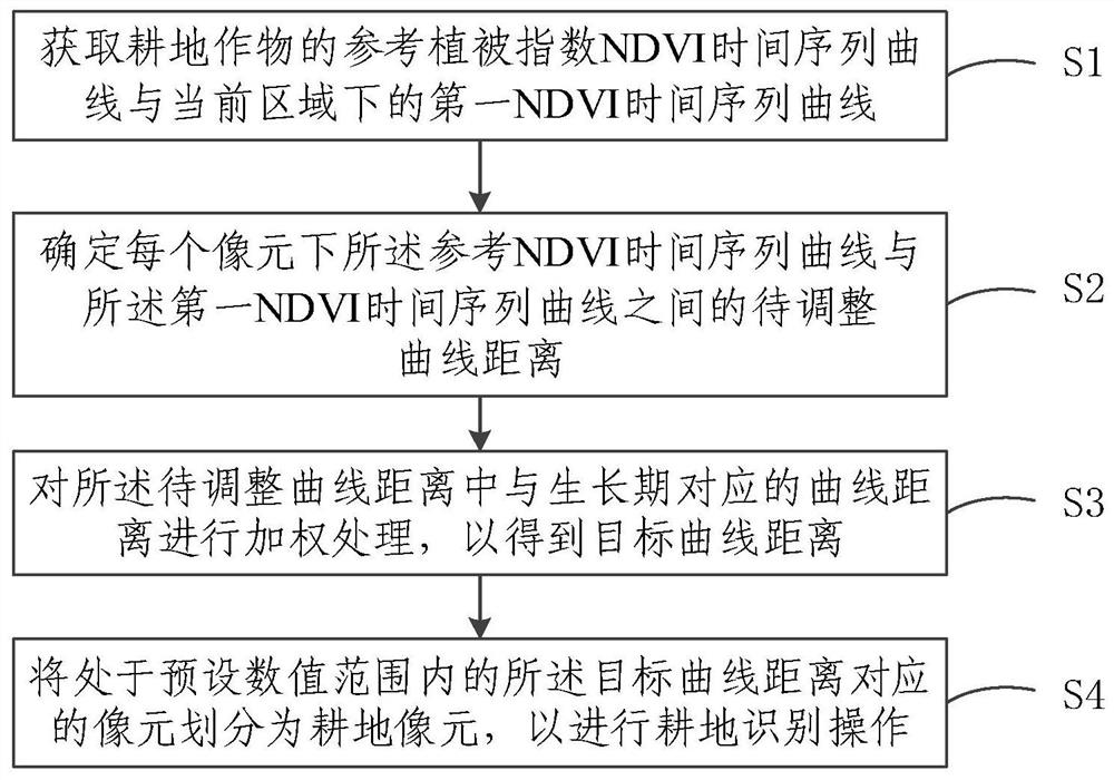
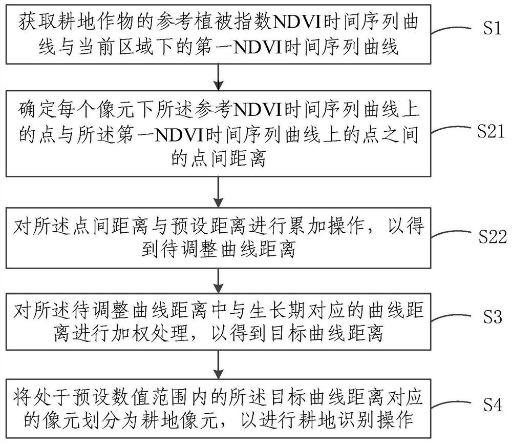
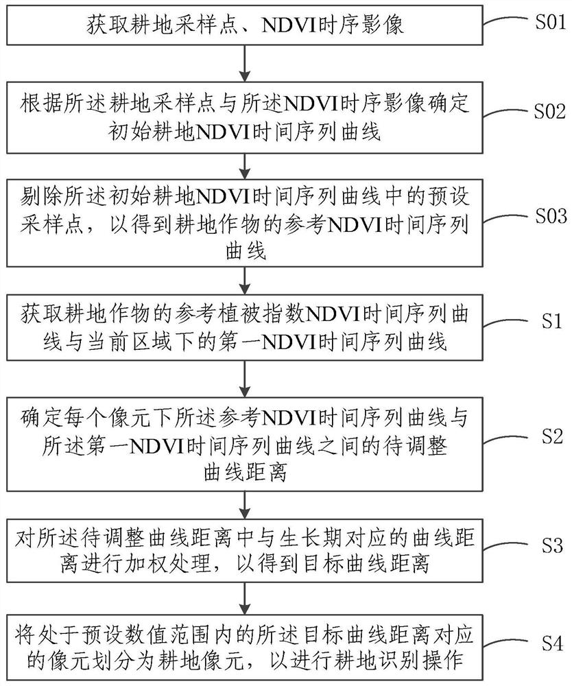
[0060] figure 1 A flow chart of a cultivated land identification method based on the distance between curves provided by the embodiment of the present invention, as shown in figure 1 As shown, the method includes:

[0061] S1. Obtain the reference vegetation index NDVI time series curve of cultivated land crops and the first NDVI time series cur...


PUM


Abstract

The embodiment of the invention relates to the technical field of remote sensing technologies, and discloses a cultivated land identification method, system and device based on the distance between curves, and a storage medium. The method comprises the steps of acquiring an NDVI time sequence curve of cultivated land crops and a first NDVI time sequence curve under a current area; determining a to-be-adjusted curve distance between the reference NDVI time sequence curve and the first NDVI time sequence curve under each pixel; performing weighting processing on a curve distance corresponding tothe growth period in the to-be-adjusted curve distances to obtain a target curve distance; and dividing the pixels corresponding to the target curve distance in the preset numerical range into cultivated land pixels. According to the embodiment of the invention, weighting processing can be carried out on the curve distance of the growing period part, the remote sensing classification precision for the cultivated land finally can be improved, and the technical problem that the cultivated land information is difficult to extract accurately by the existing remote sensing data classification technology is solved.

Description

technical field [0001] The present invention relates to the technical field of remote sensing technology, in particular to a method, system, equipment and storage medium for identifying cultivated land based on the distance between curves. Background technique [0002] Land cover is one of the basic elements of the natural environment in which humans live, and changes in land cover have a profound impact on environmental quality, biodiversity, productivity and adaptability of terrestrial ecosystems. [0003] To gain a better understanding of land cover status, land cover classification methods can be applied. [0004] As far as the land cover classification method is concerned, the land cover classification method is a key technology to understand the distribution characteristics and regional structure of land cover. At the same time, remote sensing technology has become the main data source for land cover classification due to its advantages of low cost and high efficiency....

Claims


Application Information

Patent Timeline
Patent Type & Authority Applications(China)
IPC IPC(8): G06K9/00G06K9/62
CPCG06V20/188G06F18/22G06F18/2413G06F18/24147
Inventor 黄翀
Owner INST OF GEOGRAPHICAL SCI & NATURAL RESOURCE RES CAS
Why Eureka
Try Eureka